Latitude: 55.7755 / 55°46'31"N
Longitude: -2.0113 / 2°0'40"W
OS Eastings: 399391
OS Northings: 653578
OS Grid: NT993535
Mapcode National: GBR G1DN.CG
Mapcode Global: WH9YK.23J7
Plus Code: 9C7VQXGQ+6F
Entry Name: Former toll house, 2, Castle Terrace
Listing Date: 31 January 2012
Grade: II
Source: Historic England
Source ID: 1405597
ID on this website: 101405597
Location: Berwick-upon-Tweed, Northumberland, TD15
County: Northumberland
Civil Parish: Berwick-upon-Tweed
Built-Up Area: Berwick-upon-Tweed
Traditional County: Northumberland
Lieutenancy Area (Ceremonial County): Northumberland
Church of England Parish: Berwick Holy Trinity and St Mary
Church of England Diocese: Newcastle
Tagged with: Architectural structure
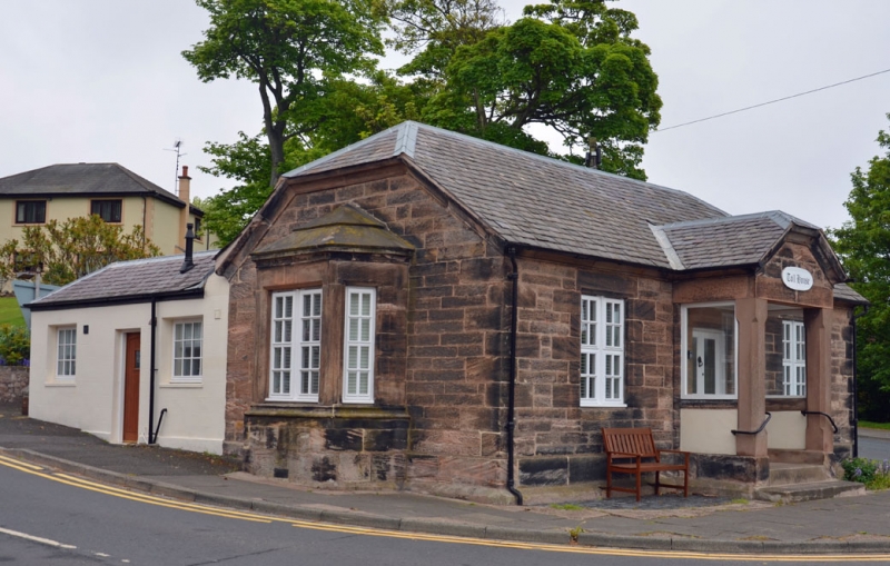
A former toll house constructed between 1839 and 1852.
MATERIALS: Coursed sandstone with ashlar quoins and a dark slate roof.
PLAN: It is L-shaped in plan, overlooking the convergence of three roads, with the front range aligned south-west to north-east.
EXTERIOR: The main elevation faces south-east towards Castle Bridge, while the returns to the south-west and north-east have canted bays overlooking Castle Terrace and North Road respectively. It is constructed in coursed sandstone with ashlar quoins and has a half-hipped dark slate roof with a rolled metal ridge. It is of one storey and L-shaped in plan, with a modern range to the rear along Castle Terrace; this later range is not of special interest. The main elevation is of three bays, with quoined large window openings flanking a central gabled porch with chamfered square pillars and half-glazed sides. The two-leaf door sits within a chamfered surround and is glazed to the upper panels. All windows are renewed.
INTERIOR: This was not inspected; however it is believed to retain an entrance hall with one room to either side.
This building has been suggested as having been constructed in the early-C19 and possibly later moved to this position. A toll house first appears on John Wood's map of 1822 positioned to the south of what is now Castle Bridge, while an example in this position is first depicted on the 1852 Board of Health map. A map of 1839 depicting the planned course of the railway also places the toll in the earlier position. It is likely that the property under assessment was purpose-built rather than moved, as the example on John Wood's map was positioned with its east gable end overlooking the ropery, making a bay window to this elevation redundant. This evidence, along with the style of construction, suggests this toll house dates to the period 1839-1852, possibly coinciding with the construction of the railway station in 1847. This move would have meant paying a toll to access the station facilities from the north, whereas the previous position would not. The building was converted into a residential property during the C20, with an extension to the rear added at some point after 1932. This sits on the footprint of some previously attached ranges, most likely a W.C. and coal shed. It has most probably lost a chimney, as a central stack would be expected in a building of this type.
The former toll house at no. 2 Castle Terrace, mid-C19, is designated at Grade II for the following principal reasons:
* Functional: it demonstrates clear evidence of its original use, with all three working elevations retaining their functional character
* Historic: this toll house overlooks three, rather than the more common one or two roads, including the nationally-significant Great North Road
* Architectural: its position as a focal point, when combined with a design influenced by polite architecture, provides a certain level of authority which is a good example of its type
* Intactness: it is comparable with designated examples of a similar date, with later alterations not affecting the functional character of the property
External links are from the relevant listing authority and, where applicable, Wikidata. Wikidata IDs may be related buildings as well as this specific building. If you want to add or update a link, you will need to do so by editing the Wikidata entry.


Other nearby listed buildings