Approximate Location Map
Large Map »
Latitude: 54.0343 / 54°2'3"N
Longitude: -0.8819 / 0°52'54"W
OS Eastings: 473330
OS Northings: 460386
OS Grid: SE733603
Mapcode National: GBR QP8S.WL
Mapcode Global: WHFBT.FV9N
Plus Code: 9C6X24M9+P7
Entry Name: Church Hall, Scrayingham
Listing Date: 16 April 2013
Grade: II
Source: Historic England
Source ID: 1406419
ID on this website: 101406419
Location: Scrayingham, North Yorkshire, YO41
County: North Yorkshire
District: Ryedale
Civil Parish: Scrayingham
Traditional County: Yorkshire
Lieutenancy Area (Ceremonial County): North Yorkshire
Church of England Parish: Scrayingham St Peter and St Paul
Church of England Diocese: York
Tagged with: Church hall
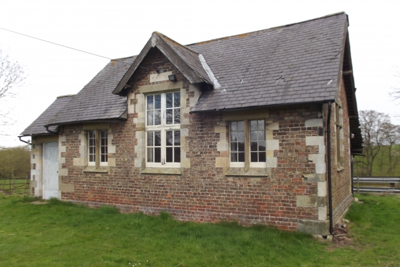
A mid-C19 former school, then church hall.
Hall, formerly a parochial school, of 1853, probably by G T Andrews.
MATERIALS: constructed of red brick in English garden wall bond, with stone dressings to the door, windows and quoins, under a grey slate roof.
PLAN: the single storey building has a single room with an attached porch to the side and a kitchen to the rear. It stands back from the road to the south, with an area of grass where the former school yard stood, and is bounded by iron rail fencing.
EXTERIOR: the front of the building has three windows, two of two lights with stone mullion and dressings and a larger central window with replacement timber mullion and transom, set below a gablet with plain timber barge boards. A date stone above the window reads AD MDCCCXLCIII (not a valid number; 1853 is the correct date). To the left is a lower section which contains the main entrance with a plank timber door with stone dressings. The gable end on the right return has a stone mullioned and transomed window and a small single light above, both with stone dressings. To the right is a half-glazed timber door in the rear extension. The porch on the left return has a narrow window in the gable end; the porch is narrower than the main building which has fenestration similar to the right return but with the main window offset to the rear. At the rear the main roof is extended to form an extension with a single window, and there is a further low single storey brick extension with doors to either side.
INTERIOR: the porch leads to the main room which has a lowered ceiling and timber floorboards. A galley kitchen is in the rear extension. Access to the toilets is from the exterior.
The former school was built in the mid C19, at the same time as the adjacent church of St Peter and St Paul was restored. The architect was probably G T Andrews, who also worked on the church. Andrews was a notable railway architect, based in York, who designed numerous railway buildings on George Hudson's lines including the Old Station, York (listed Grade II*) as well as restoring a number of churches.
The building is marked on the OS 1:10,000 map (1st edition) of 1854 as a Parochial School. The 1893 1:2500 OS map shows the building with a similar footprint though without the rear extension which was added in the C20. The school was in use until the 1950s and was subsequently used as a community facility until the mid 1990s. It is now largely unused. At one time it had finials at the gable ends but these have been removed.
The 1853 Church Hall former school at Scrayingham is designated at Grade II for the following principal reasons:
* Architectural interest: although simple in style, the design is well executed and complements the restored church alongside;
* Alteration: the building has been very little altered, with few losses and only a small extension at the rear which does not impact on the interest of the building;
* Setting: the former school sits within its own grounds, forming an entrance to the village from an area of open ground;
* Group Value: the hall forms a group with the listed Church of St Paul and is one of a group of buildings associated with the church at the northern edge of the village.
External links are from the relevant listing authority and, where applicable, Wikidata. Wikidata IDs may be related buildings as well as this specific building. If you want to add or update a link, you will need to do so by editing the Wikidata entry.


Other nearby listed buildings
