Latitude: 53.6094 / 53°36'33"N
Longitude: -1.7016 / 1°42'5"W
OS Eastings: 419843
OS Northings: 412580
OS Grid: SE198125
Mapcode National: GBR JVKP.FV
Mapcode Global: WHCB8.TJXT
Plus Code: 9C5WJ75X+Q9
Entry Name: Old Forge
Listing Date: 22 April 2015
Grade: II
Source: Historic England
Source ID: 1420785
ID on this website: 101420785
Location: Kirkburton, Kirklees, West Yorkshire, HD8
County: Kirklees
Civil Parish: Kirkburton
Built-Up Area: Huddersfield
Traditional County: Yorkshire
Lieutenancy Area (Ceremonial County): West Yorkshire
Church of England Parish: Kirkburton All Hallows
Church of England Diocese: Leeds
Tagged with: Smithy
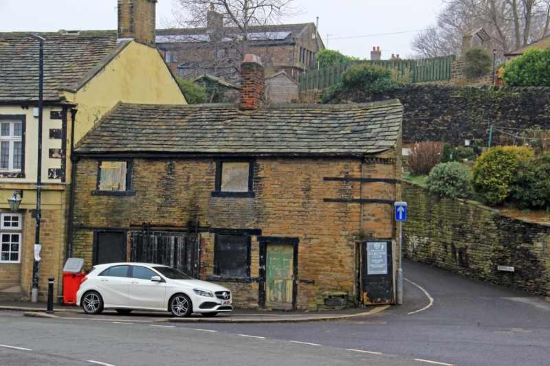
Former cottage and stable later adapted for use as a shop and blacksmiths' forge. C18 with C19 and C20 alterations. Coursed sandstone 'bricks' of varying size with ashlar dressings, slate roof, 2-storeys.
Former cottage and stable later adapted for use as a shop and blacksmiths' forge. C18 with C19 and C20 alterations. Coursed sandstone 'bricks' of varying size with ashlar dressings, slate roof, 2-storeys.
PLAN: the building lies parallel with George Street at the junction with School Hill and has a rectangular plan with a curved south-east corner that follows the curving line of School Hill. The George Inn is attached to the north-west end of the building and is not included within the Listing. A later structure depicted on OS mapping (including that below) to the rear of the building is no longer extant.
EXTERIOR: Front (south-west) elevation: the building's front elevation facing George Street consists of four alternate windows and doors to the ground floor, all with painted ashlar surrounds. The two windows are boarded over externally, but multipaned windows are visible internally. The doorway on the right contains a panelled door, but the doorway on the left has been enlarged and a later timber sliding door inserted (probably carried out when the building was converted into a smithy/forge in the early-C20). Attached to the right of the elevation is a stone mounting block. Set to the first floor, in line with the ground-floor windows, are two smaller square windows; that to the left has a plank and batten timber shutter with strap hinges, whilst that to the right is boarded over externally. Set to the centre of the building's pitched roof is a C20 brick ridge stack, which is believed to have replaced the original stack when the building was converted into a forge. The south-east corner of the building at the far right of the front elevation is curved and incorporates a dentil cornice to its upper part and a narrow former shop window to the ground floor. Later strap ties have also been added to the corner to stop movement.
Rear (north-east) elevation: the rear elevation has been rendered at some point in the past, although most of the render, which is scored to imitate ashlar stonework, has subsequently been removed/fallen off. A blocked-up ground-floor window and door are both visible, although only the upper part of the door is visible due to the ground level having been substantially raised at the rear of the building (a plank door is fully visible internally).
INTERIOR: internally the building is divided by a party wall into two halves, with two rooms to the ground floor and one to the first floor at the north-west end; a corresponding first-floor room in the south-eastern half has been lost due to the fact that the floor was removed when the space was converted into a forge. The north-western ground-floor room has been used as a stable and has a stone sett floor, saddle pegs fixed to the walls, and substantial ceiling beams with chamfered edges. An open trapdoor and wooden foot-hole ladder provide access to the room above (possibly a hayloft and/or additional accommodation), which retains early rafters and purlins and a pegged king-post truss. The south-eastern room has a stone flag floor and was last used as a forge. An early-C20 forge kiln has been inserted into a former domestic stone fireplace at ground-floor level, with its flue rising up to utilise the former cottage's pre-existing chimney and a further fireplace above. The roof structure is similarly styled to the north-western half of the building with early rafters and purlins and a pegged king-post truss. Structural ties protrude through the south-east corner into the space.
The Old Forge is believed to have been constructed in the C18 as a cottage with an attached stable, the cottage part of which was later adapted for use as a shop. The building is situated on an old turnpike road adjacent to the George Inn, which is also believed to have C18 origins. The building is depicted on the 1753 Township Map of Kirkburton, although its shape is not wholly distinct. It is more clearly depicted on the 1813 Enclosures Map and also a map dating to 1816.
In 1920 the building was rented by a local blacksmith and the cottage/shop converted into a smithy/forge. The building ceased use as a forge in the 1980s and has subsequently been partly used as a garage and store.
The Old Forge is listed at Grade II for the following principal reasons:
* Architectural interest: it is an interesting example of an evolved vernacular building where its historical development from C18 domestic to early-C20 small-scale industrial use is clearly reflected in the physical fabric;
* Interior legibility and survival: the building's original floor plan and the functionality of spaces remains clearly legible, and numerous interior features survive, including pegged roof timbers throughout the building, the stable's stone-sett floor, substantial ceiling beams with chamfered edges, and foot-hole ladder accessing the hayloft above, and the former cottage's stone-flag floor and fireplaces; the latter having been incorporated into the early-C20 forge kiln.
External links are from the relevant listing authority and, where applicable, Wikidata. Wikidata IDs may be related buildings as well as this specific building. If you want to add or update a link, you will need to do so by editing the Wikidata entry.


Other nearby listed buildings