Approximate Location Map
Large Map »
Latitude: 52.9024 / 52°54'8"N
Longitude: -2.2534 / 2°15'12"W
OS Eastings: 383051
OS Northings: 333911
OS Grid: SJ830339
Mapcode National: GBR 15L.13H
Mapcode Global: WHBDC.C95T
Plus Code: 9C4VWP2W+WJ
Entry Name: Workshop and Storehouse at Mill Meece Pumping Station
Listing Date: 23 March 2015
Grade: II
Source: Historic England
Source ID: 1423434
ID on this website: 101423434
Location: Stafford, Staffordshire, ST21
County: Staffordshire
District: Stafford
Civil Parish: Standon
Traditional County: Staffordshire
Lieutenancy Area (Ceremonial County): Staffordshire
Church of England Parish: Swynnerton and Cotes Heath
Church of England Diocese: Lichfield
Tagged with: Architectural structure
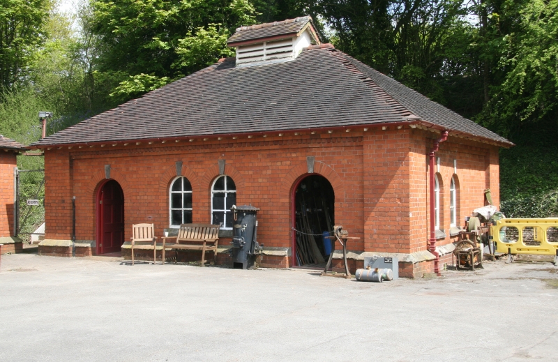
Workshop and storehouse at Mill Meece pumping station, now museum, built circa 1914 for the Staffordshire Potteries Waterworks Company. Designed by William Campbell and constructed by Thomas Godwin and Son.
Workshop and storehouse at water pumping station, now museum, built circa 1914 for the Staffordshire Potteries Waterworks Company. Designed by William Campbell and constructed by Thomas Godwin and Son.
MATERIALS: of Accrington red brick in English bond with stone dressings and a clay-tiled roof
PLAN: it is a single-storeyed building with a rectangular plan.
EXTERIOR: the building has a chamfered stone plinth, raised quoins, brick cogging and a hipped roof with exposed rafter ends and a louvered ridge vent. Its principal elevation, which faces south-west, is symmetrical, with central paired windows with flanked by doorways with panelled doors at each end. Both returns have paired windows, the left-hand return also with a doorway containing a panelled door. Windows are six-paned casements with chamfered stone lintels whilst the window and door openings are round-headed with gauged brick arches with keystones.
INTERIOR: the building is dived into two rooms and retains some original, fixed, wooden shelving. It now houses a collection of machinery acquired from other pumping stations prior to their demolition.
The Staffordshire Potteries Waterworks Company was established by an Act of Parliament in 1847 to supply water to the industrial towns of North Staffordshire. In 1899 the Company decided to supplement its pumping station at Hatton, opened in 1892, with a new facility in the Meece valley. It subsequently purchased seven acres of land at Birch House Farm in Millmeece, some 2 miles to the south. With six wells and five boreholes at Hatton, the Company was expecting to obtain a copious water supply from the same geological series. However, test bore holes sunk between 1899 and 1901 could not locate an adequate supply and it was subsequently concluded that the chosen site lay on the wrong side of the Swynnerton geological fault. Further boreholes and a well were sunk between 1903 and 1909 on an additional plot of land at Millmeece Farm, on the northern edge of the site. As the initial trials proved successful, the Company acquired the land from the Swynnerton Estate in 1907 as the location for its new facility.
Following the granting of permission to build by an Act of Parliament of 1912, the Company commissioned the architect William Campbell of Hanley to design the buildings and appointed Thomas Godwin and Sons of Hanley as builder. However, shortly after the site plan was finalised, a minor geological fault associated with the Swynnerton fault was found to run under the location assigned to the engine house. The engine and boiler houses were subsequently repositioned, with the revised site plan resulting in the boiler house chimney standing adjacent to the engine house rather than the boiler house itself. Although it is unclear as to why this peculiar arrangement came about, it has been suggested that work on the chimney had already begun before the fault was discovered, with the Company deciding to leave the chimney standing where it was being built rather than have it re-sited, probably at considerable expense. The majority of the pumping station buildings, including the engine and boiler houses, along with the chimney, workshop/storehouse, winch house and weigh house, were completed in 1914, with two engineer’s cottages being finished in 1915.
The Company’s tender to supply one compound tandem rotative steam engine and two Lancashire boilers, along with supporting beams and pipe-work for a future second engine, was awarded to Ashton, Frost and Co Ltd of Blackburn. The engine was installed in June 1914 and started for the first time on 25th November 1914. However, problems with the pumps delayed the plant from becoming operational until 18th January 1915, when it regularly pumped four million gallons per day to waste to keep the water levels down whilst the construction of the two boreholes were completed. In the same year a second well was sunk and a new main to Hanchurch reservoir was laid. Further problems with sand in both the boiler system valves and the temporary borehole pump resulted in the sinking of the boreholes being suspended for the duration of the First World War. In 1919 permanent borehole pumps were fitted and the station finally pumped into the supply for the first time, some twenty years after the first test bore hole had been sunk.
In August 1927, a second compound tandem rotative steam engine, along with a third Lancashire boiler, was installed by Hathorn, Davey and Co Ltd of Leeds, with the engine starting work on 5th May 1928. Two additional boreholes were sunk from the second well between February 1926 and April 1929.
In 1937 the borehole pump driven by the 1914 engine was dismantled and replaced by two electrically operated pumps supplied by Mather and Platt Ltd of Manchester. A temporary wooden building was erected over the well head to house the electrical plant and a small brick building, now known as the Sutherland Room, was erected at the north-east end of the engine house to accommodate the surface pump and motor.
During the Second World War a blast wall (now demolished) was constructed around the well-head, whilst a refuge was built into the embankment near the workshop.
The possibility of increasing capacity by replacing the steam engines with steam-driven turbines, operating from the existing boilers, was investigated in 1951 but quickly dropped when a delivery date of 1957 was quoted. As an alternative, a Mather and Platt electric pumping system was installed in the second bore hole. In 1965 mechanical stokers were fitted to the boilers and a small coal store was added to the boiler house.
In 1978, with the station now owned by Severn Trent Water, plans were drawn up to replace the steam engines with two multi-stage submersible pumps capable of delivering four million gallons of water a day directly from the base of the boreholes. In the following year a single-storey building was erected to the north-west of the engine house to accommodate the control panels, whilst the wooden well-head building of 1938 was demolished to allow the pumps to be installed.
In 1981 the Mill Meece Pumping Station Preservation Trust Ltd took out a 99-year lease to restore, maintain and operate the steam engines, operating the pumping station as a museum. To accommodate visitors, a public convenience was added to the site in 1979, whilst No. 1 Engineer’s Cottage became a meeting room and food preparation area. In 1993, the late-C20 pumping plant, which is still in operational use (2014), was supplemented with the addition of a chlorine treatment building, erected on land to the south-west of the engine house.
The workshop and storehouse at Mill Meece pumping station, built circa 1914 for the Staffordshire Potteries Waterworks Company, is listed at Grade II for the following principal reasons:
* Architectural interest: its restrained classical style is well realised, reflecting the high value placed on creating an architecturally integrated ensemble of pumping station buildings within the Staffordshire countryside;
* Integrated site: it forms part of an exceptionally complete water pumping station site, being integral to its original design and purpose;
* Intactness: it stands unaltered, only being subject to remedial repairs.
External links are from the relevant listing authority and, where applicable, Wikidata. Wikidata IDs may be related buildings as well as this specific building. If you want to add or update a link, you will need to do so by editing the Wikidata entry.


Other nearby listed buildings
