Approximate Location Map
Large Map »
Latitude: 52.3873 / 52°23'14"N
Longitude: -2.7632 / 2°45'47"W
OS Eastings: 348152
OS Northings: 276854
OS Grid: SO481768
Mapcode National: GBR BJ.QLDT
Mapcode Global: VH843.2818
Plus Code: 9C4V96PP+VP
Entry Name: Bromfield War Memorial
Listing Date: 7 September 2016
Grade: II
Source: Historic England
Source ID: 1437246
ID on this website: 101437246
Location: Bromfield, Shropshire, SY8
County: Shropshire
Civil Parish: Bromfield
Traditional County: Shropshire
Lieutenancy Area (Ceremonial County): Shropshire
Church of England Parish: Bromfield
Church of England Diocese: Hereford
Tagged with: War memorial
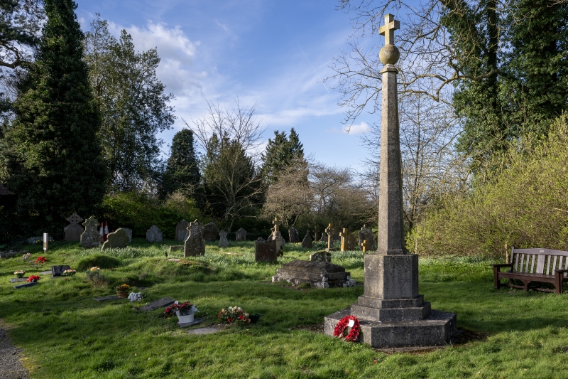
A churchyard First World War memorial of 1921, with later additions for the Second World War and the Palestine Civil War.
A churchyard First World War memorial of 1921, altered after 1945.
MATERIALS & PLAN: limestone, with a cross and ball above a hexagonal shaft with plinth, stepped base and rectangular platform. The memorial faces south-west to the path which leads from the churchyard lych-gate to the north-west door of the church.
The pinnacle of the monument has a cross with chamfered and splayed arms above a ball. Below this is a moulded cap to the tapered hexagonal shaft. The plinth has straight sides which bear the following inscription to the south-west face: IN / MEMORY OF THE MEN / OF THIS PARISH WHO / GAVE THEIR LIVES TO / SAVE THEIR COUNTRY / IN THE GREAT WAR / 1914 – 1918. / AND / 1939 – 1945. Below this the base has three steps. The north-eastern face bears the names of the fallen on the plinth and below this the name of the single fallen servicemen from the Second World War and the Palestine Civil War of 1947 are inscribed on the risers of two of the steps of the base.
This List entry has been amended to add sources for War Memorials Online and the War Memorials Register. These sources were not used in the compilation of this List entry but are added here as a guide for further reading, 23 November 2017.
The aftermath of the First World War saw the biggest single wave of public commemoration ever with tens of thousands of memorials erected across England, as a result of both the huge impact the loss of three quarters of a million British lives had on communities, and also the official policy of not repatriating the dead, which meant that the memorials provided the main focus of the grief felt at this great loss. One such memorial was raised at Bromfield, Shropshire as a permanent testament to the sacrifice made by the members of the local community who lost their lives in the First World War.
The memorial was completed by September 1921 and unveiled by the Earl of Plymouth and dedicated by the Bishop of Hereford.
Bromfield War Memorial, Shropshire is listed at Grade II for the following principal reasons:
* Historic interest: as an eloquent witness to the tragic impact of world events on the local community, and the sacrifice it made in the conflicts of the C20;
* Architectural interest: as an accomplished and well-realised war memorial, which takes the form of a limestone shaft supporting a ball and cross;
* Group value: the monument has group value with the church of St Mary, Bromfield (Grade I).
External links are from the relevant listing authority and, where applicable, Wikidata. Wikidata IDs may be related buildings as well as this specific building. If you want to add or update a link, you will need to do so by editing the Wikidata entry.


Other nearby listed buildings
