Approximate Location Map
Large Map »
Latitude: 52.4635 / 52°27'48"N
Longitude: -2.15 / 2°8'59"W
OS Eastings: 389907
OS Northings: 285073
OS Grid: SO899850
Mapcode National: GBR 47Z.J8
Mapcode Global: VH91H.PB8T
Plus Code: 9C4VFV72+C2
Entry Name: Memorial Archway at Stourbridge War Memorial Athletic Ground
Listing Date: 10 July 2017
Grade: II
Source: Historic England
Source ID: 1439656
ID on this website: 101439656
Location: Stourbridge War Memorial Athletic Ground, Amblecote, Dudley, West Midlands, DY8
County: Dudley
Electoral Ward/Division: Amblecote
Parish: Non Civil Parish
Built-Up Area: Stourbridge
Traditional County: Staffordshire
Lieutenancy Area (Ceremonial County): West Midlands
Tagged with: War memorial
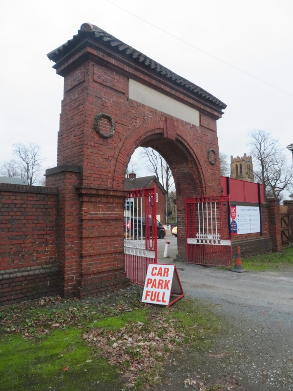
A war memorial archway which forms the entrance to a sports ground, designed by the Stourbridge Borough Surveyor, Geoffrey Ince, at a cost of £220 and unveiled in December 1928.
A war memorial archway which forms the entrance to a sports ground, designed by the Stourbridge Borough Surveyor, Geoffrey Ince, at a cost of £220 and unveiled in December 1928.
MATERIALS & PLAN: the archway is of red, Ketley brick, laid in English bond, with stone dressings and a pantiled cap. The gates are cast and wrought iron, made by Hill and Smith of Brierley Hill.
EXTERIOR: both eastern and western faces are similar. The brick arch has banded rustication to the lower body of the piers at either side and this is topped by a projecting band of headers at the level of the springing of the arch. A raised band of stretchers surrounds the semi-circular arch and there is a triple keystone motif of bricks to the head. The spandrels at either side on both the eastern and western flanks have carved stone laurel wreaths in high relief. The wall diminishes in thickness by stages and to the top of the wall is a frieze with panels of raised brickwork. Both sides have a stone panel to the centre, and that on the eastern, road front reads ‘STOURBRIDGE / WAR MEMORIAL / ATHLETIC GROUND’. Above this is a projecting brick cornice and the monument is topped by a hipped cap of pantiles. The west face is similar, except that the central stone plaque is blank. Piers at either side connect to the lateral flanking walls which run N-S. That to the south has a gateway at its southern end flanked by brick piers.
This List entry has been amended to add sources for War Memorials Online and the War Memorials Register. These sources were not used in the compilation of this List entry but are added here as a guide for further reading, 20 July 2017.
The land on which the Stourbridge Athletics Ground is situated was known in the C17 as Gibbon’s Piece and was originally one of the open fields in the manor of Amblecote known as ’Watery Fields’. From the early C19 cricket was played on the ground, under the patronage of the Earl of Stamford, who owned the land. Stourbridge Football Club began using the ground from 1888. In 1927, as a result of the Public Health Act of 1925, the borough bought the land and, following this purchase the Football Club paid for new stands. At the same time, several more of the ground’s buildings, including the entrance archway (opened in 1928), the northern turnstile building (1932) and sports pavilion (1928) were all, to some degree, the gift of Ernest Stevens, a local JP and hollow ware manufacturer, who was a noted philanthropist in Stourbridge. Worcestershire County cricket matches were played here between 1905 and 1981 and the ground is still used by Stourbridge FC.
The Memorial Archway and lateral walling at Stourbridge Memorial Athletic Ground, High Street Amblecote is listed at Grade II for the following principal reasons:
* Historic interest: as an eloquent witness to the tragic impact of world events on this community, and the sacrifices it made in the conflicts of the C20;
* Architectural interest: as an accomplished and well-realised war memorial and park structure, designed by the borough engineer, Geoffrey Ince;
* Group value: with the turnstile building which is also recommended for statutory listing. The group of archway, walled enclosure and turnstile building forms an effective war memorial, whose power lies in its simple form and architectural strength.
External links are from the relevant listing authority and, where applicable, Wikidata. Wikidata IDs may be related buildings as well as this specific building. If you want to add or update a link, you will need to do so by editing the Wikidata entry.


Other nearby listed buildings
