Latitude: 53.4257 / 53°25'32"N
Longitude: 0.1905 / 0°11'25"E
OS Eastings: 545645
OS Northings: 394339
OS Grid: TF456943
Mapcode National: GBR YXST.1P
Mapcode Global: WHJKT.W5W3
Plus Code: 9F52C5GR+75
Entry Name: First World War pillbox, Sea Lane, Saltfleet
Listing Date: 28 June 2017
Grade: II
Source: Historic England
Source ID: 1445089
ID on this website: 101445089
Location: Saltfleet, East Lindsey, Lincolnshire, LN11
County: Lincolnshire
District: East Lindsey
Civil Parish: Skidbrooke with Saltfleet Haven
Built-Up Area: Saltfleet
Traditional County: Lincolnshire
Lieutenancy Area (Ceremonial County): Lincolnshire
Tagged with: Architectural structure
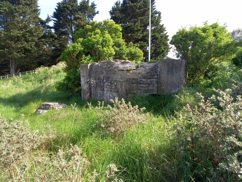
Pillbox, built 1917.
Pillbox, built 1917.
MATERIALS: concrete, reinforced with expanded metal lath sheeting (Expamet) and steel rails, poured in situ with timber shuttering internally, sandbag shuttering externally.
PLAN: single cell trapezoid.
EXTERIOR: set into the eastern slope of the sea bank at Sea Lane, Saltfleet. NE (seaward) elevation is blind and convex. NW and SE elevations each have a single, low set, wide-splayed machine gun embrasure. The base of a Second World War period steel-framed bombing range quadrant post comprising smooth surfaced concrete foundation pillars, with holdfast bolts in their upper surfaces, are cast against both the NW and SE walls. SW rear wall is totally obscured by the build-up of the sea bank. The roof slab has a central round vent that has been blocked by a modern circular steel cap with ‘E + A’ stencilled into it. (not of special interest). The exterior of the structure has a rusticated appearance left by the sandbag shuttering and the front edge of the roof irregular lumps of concrete to disrupt the outline of the structure.
INTERIOR: access is blocked and filled with sand. The walls have smooth whitewashed concrete surfaces, with horizontal plank shuttering witness marks.
Although it is not known exactly when the First World War pillbox at Sea Lane was built, it is clear that it was constructed as part of an organised coastal defence system with a series of near identical pillboxes placed at 1000 yard intervals. Their design, with single machine gun embrasures to either side to produce flanking fire across the fronts of the neighbouring pillboxes, are similar to those developed on the Western front in 1917, such as those at West Hazebrouck. The lack of front facing embrasures; the reinforced, convex curved roof at least 1m thick; and the use of sandbag shuttering to the exterior were all designed to make them ‘shell-proof’ to resist naval bombardment. This design illustrates the rapid evolution in thinking compared to those believed to be slightly earlier built on the Holderness coast north of the Humber. The pillbox is thought to have been manned by soldiers of the 7th/8th (combined) Battalions, Sherwood Foresters.
On the outbreak of the Second World War, the First World War pillbox was re-occupied and integrated into the new anti-invasion defences. Later a bombing range quadrant post associated with RAF Theddlethorpe was erected over the pillbox, with concrete foundation pillars attached to the side walls. Post-war, the interior has been filled with sand and all access has been blocked.
The First Word War pillbox at Sea Lane, Saltfleet, built in 1917, is listed at Grade II for the following principal reasons:
Historic interest:
* Date and rarity: built in 1917, First World War pillboxes are rare survivals;
Architectural interest:
* Technology: as an illustration of the evolving technology and defensive tactics in 1917;
* Group value: as a coherent linear group of First World War pillboxes functionally and physically associated with later Second World War defensive structures.
External links are from the relevant listing authority and, where applicable, Wikidata. Wikidata IDs may be related buildings as well as this specific building. If you want to add or update a link, you will need to do so by editing the Wikidata entry.


Other nearby listed buildings