Approximate Location Map
Large Map »
Latitude: 51.7745 / 51°46'28"N
Longitude: -2.2902 / 2°17'24"W
OS Eastings: 380070
OS Northings: 208463
OS Grid: SO800084
Mapcode National: GBR 0KR.PST
Mapcode Global: VH94Q.8N3K
Plus Code: 9C3VQPF5+QW
Entry Name: Standish War Memorial
Listing Date: 1 December 2017
Grade: II
Source: Historic England
Source ID: 1452256
ID on this website: 101452256
Location: St Nicholas's Church, Standish, Stroud, Gloucestershire, GL10
County: Gloucestershire
District: Stroud
Civil Parish: Standish
Traditional County: Gloucestershire
Lieutenancy Area (Ceremonial County): Gloucestershire
Tagged with: War memorial
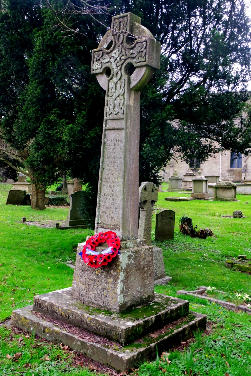
A First World War memorial, built in 1920 by Freebury and Hillman of Stroud; altered after the Second World War.
A First World War memorial, built in 1920 by Freebury and Hillman of Stroud; altered after the Second World War.
MATERIALS: Minchinhampton limestone.
DESCRIPTION: the memorial consists of a Celtic cross, carved with interlacing. The tapering column terminates in a base set on a two-stepped plinth with platform. The memorial is inscribed on the north side: ERECTED/ BY THE / PARISHIONERS / OF / STANDISH / PAST AND / PRESENT / IN GRATEFUL / MEMORY / OF THE MEN / WHO GAVE / THEIR LIVES / FOR THE / FREEDOM / OF THEIR / COUNTRY / DURING THE / GREAT WAR / 1914-1918 / [NAMES] / THEIR NAMES LIVETH FOR EVERMORE.
On the south side: A LATER GENERATION OF / PARISHIONERS HERE PAYS / GRATEFUL TRIBUTE TO / GRANVILLE WILLIAM STOPFORD / FLIGHT SERGEANT ROYAL / AIR FORCE WHO GAVE HIS / LIFE IN THE WORLD WAR / 1939-1945.
The aftermath of the First World War saw the biggest single wave of public commemoration ever with tens of thousands of memorials erected across England. This was the result of both the huge impact on communities of the loss of 750,000 British lives, and also the official policy of not repatriating the dead which meant that the memorials provided the main focus of the grief felt at this great loss. One such memorial was raised at Standish, as a permanent testament to the sacrifice made by the members of the local community who lost their lives in the First World War.
The memorial was set up in 1920 in a prominent location in the churchyard of the Church of St Nicholas, alongside the main road. It was built by local masons Freebury and Hillman of nearby Stroud. The ceremony of dedication took place on 19 December 1920, during which the memorial was unveiled by Major Sir Lionel Darell, Bart, DSO.
The memorial commemorates nine local servicemen who died during the First World War. Following the Second World War, a dedication was added to commemorate the one man who fell in that conflict.
The war memorial underwent conservation work in 2017, with the help of grant aid administered by the War Memorials Trust.
Standish War Memorial is listed at Grade II, for the following principal reasons:
Historic interest:
* as an eloquent witness to the tragic impact of world events on the local community, and the sacrifice it made in the conflicts of the C20.
Architectural interest:
* for its design, a well-executed stone cross, with good carved detailing by Freebury and Hillman of Stroud.
Group value:
* with the Grade I-listed Church of St Nicholas, in whose churchyard it stands, along with a number of listed tombs and memorials, with which it forms a commemorative grouping.
External links are from the relevant listing authority and, where applicable, Wikidata. Wikidata IDs may be related buildings as well as this specific building. If you want to add or update a link, you will need to do so by editing the Wikidata entry.


Other nearby listed buildings