Approximate Location Map
Large Map »
Latitude: 54.8792 / 54°52'45"N
Longitude: -2.8302 / 2°49'48"W
OS Eastings: 346828
OS Northings: 554140
OS Grid: NY468541
Mapcode National: GBR 8DP0.1R
Mapcode Global: WH804.HMHD
Plus Code: 9C6VV5H9+MW
Entry Name: Wetheral Abbey Farm
Listing Date: 22 January 2018
Grade: II
Source: Historic England
Source ID: 1452573
ID on this website: 101452573
Location: Wetheral, Cumberland, Cumbria, CA4
County: Cumbria
District: Carlisle
Civil Parish: Wetheral
Traditional County: Cumberland
Lieutenancy Area (Ceremonial County): Cumbria
Tagged with: Architectural structure
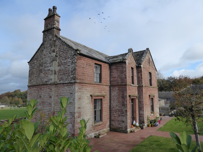
Model farm, 1857 by James Stewart of Carlisle, incorporating elements of a medieval priory and a post-medieval farmstead; the eastern part was demolished mid-C20.
Model farm, 1857 by James Stewart of Carlisle, incorporating elements of a medieval priory and a post-medieval farmstead; the eastern part was demolished mid-C20.
MATERIALS: red sandstone with ashlar dressings; graduated Westmorland and Welsh slate roofs.
PLAN: a courtyard plan farmstead with rectangular ranges and a T-shaped farmhouse with an additional east range, set slightly back from the west side.
FARMHOUSE
EXTERIOR: two-storey with a partial cellar beneath pitched roofs with ashlar quoins, coped gables and verges, prominent water tables, stone finials, plinth and a sill band. All windows are rectangular with flush ashlar surrounds fitted with mostly six-over-six un-horned sash frames. The four-bay south elevation has a left gable stack. The left end bay has a window to each floor, the slightly projecting and gabled entrance bay has the main entrance with window above, and the further projecting and gabled right end bay also has a window to each floor and a narrow attic light. The ground floor windows and door all have bracketed hoodmoulds, and the entrance has a six-panel door with a tripartite rectangular light above. Set back to the right is the blind gable of the attached east range. The left return is blind, and has a quoined central, external chimney stack. The two-bay right return (possibly later east range) is plainer and lacks the sill band; it has a left gable chimney stack, a pair of windows beneath the eaves, a large window to the ground floor left and an inserted window opening with modern casement frame to the right, replacing an original large window; an attached set of stone steps leads down to the farmyard. The four-bay north elevation has a projecting gabled bay with a plain entrance flanked by windows and a first floor window and narrow attic light. The right bay has a large stair window with a flat-roofed porch below and a ground floor window to the right with a bracketed hoodmould. Projecting forward to the left is the blind gable of the attached east range.
INTERIOR: the original plan of the building is retained, the only modifications being the sub-division of the east range first floor with light-weight partitions. The ground floor retains a range of original fittings including moulded plaster cornices, skirting boards, panelled reveals, soffits and architraves and four-panel doors. The stair hall also has a decorative corbelled stair arch, and the winder stair has an open string, stick balusters and a ramped mahogany handrail. One original stone fireplace with hexagonal jambs is retained, the other two are mid-C20 replacements. The first floor has original four-panel doors (stripped) with original door furniture, and architraves, skirtings, some simple cornices and two original fireplaces.
FARMSTEAD
EXTERIOR: a variety of two-storey buildings ranged around three sides of a rectangular yard, constructed of red sandstone with ashlar dressings. Windows and door are mostly set in flush red ashlar sandstone surrounds, and have narrow-boarded doors.
The two-storey west range is constructed of irregular stonework beneath a shallow roof of Welsh slate, pitched to the south, hipped to the north; the undulating roof line suggests the presence of an original roof structure. This range is considered to be a byre with hayloft over, and appears to be an earlier building incorporated into the 1857 farmstead. The courtyard-facing elevation has a pair of door openings with alternating quoins and chamfered jambs; several ventilation slits pierce the first floor walls to the upper floor and there is a pitching door and a later brick-built external stair to the north end. The left end bay has a window fitted with a timber ventilation frame, and there is a brick-built chimney stack. The left return has a central opening and a large window above. The right return has a ventilation slit and a ground floor opening. The rear elevation has a pair of large openings and ventilation slits to the upper floor, and to the ground floor a pair of former doors in surrounds with alternating quoins (opposing those to the main elevation), now partially blocked and forming windows. The end bay has a narrow, rectangular pitched-roof projection with plain barge boards, an entrance and two large openings; it is constructed upon the raised garden area and therefore dates to the 1857 reconfiguration of the farm.
The north range abutting the north bay of the byre, is a taller T-shaped building with a pitched roof of slate. The courtyard-facing south elevation has a wide, tall arched cart entrance with alternating quoins and a small window to the left, with to the first floor a pair of windows with ventilation frames. Immediately to the right of the cart entrance, which appears to be an insertion, there is a quoined building line running the full height of the range. To the right of this line the stonework is smaller and less regularly coursed in character. There is a blocked entrance with a flush lintel and alternating quoins similar to those in the byre range, with a small window to the right, and to the right again there is a wide double opening and a second single opening with similar alternating quoins and lintels. The first floor is blind except for a door set immediately above the double opening. The gabled right return is blind with a circular ventilation hole to the apex. The rear elevation is largely blind with an attached rectangular former engine house; it has a corrugated asbestos pitched roof, a double opening to its east side and a window to the north gable. Immediately to the left is a small opening with a lintel which might be associated with the mechanism of the original apsidal gin gang.
The low, two-storey south range has a hipped roof of Welsh slate (stone slate courses to the right return), and a pitched-roof projecting cross range at the truncated east end. The west end forms a cart shed with granary over, projecting to the rear and reached by a rear external stone stair. The court-yard facing north elevation has a rectangular double cart opening with a central stone pillar. The right return has three first floor and two ground floor windows with a variety of fixed pane and ventilation frames. A double-entrance with alternating quoins sits to the right end. Attached to the east end of the granary is a pair of stables with hayloft over, each with a first floor window and pitching door, and a single ground floor window; original stable doors have both been widened with steel lintels, leaving original door jambs to one side only. The rear stable elevation has upper ventilation slits and an open-fronted lean-to divided into sections, probably an implement shed. The original function of the cross range is unclear but probably formed further animal housing with storage above. A small single-storey pitched-roofed building attached to the north end is considered to have functioned as a dairy. The quoined, rear elevation of the cross range has an original window and door opening, the latter blocked) and an inserted entrance to the right (both with alternating jambs), and upper ventillation slits. A triangular witness mark of the lost eastern part of the south range (containing the blocked entrance) demonstrates that this was single storey with a pitched roof and a narrow rear outshut. The cross range left return has a pitching door and a double entrance with alternating jambs to ground floor.
INTERIOR: only the ground floors were generally available for inspection. The south end of the west range has a feed preparation room with a timber ladder to the upper floor, a boiler in one corner associated with a brick flue, and a stone slab table. A door leads into the full-height rear narrow projection (now subdivided), considered to be a crop store. The remainder of the range's very low ground floor is divided into three byres, two inspected with whitewashed walls and a central manure passage flanked by raised, kerbed cobbled areas. The north range comprising a threshing barn is divided into two parts (along the building line visible on the exterior) by a suspended brick wall supported on a substantial sawn beam; the western part has a flagged threshing floor and a rear door opening into the former engine house. The lower, eastern part of the barn has an inserted sawn-timber floor supported on a substantial square timber, and an earth floor, with a timber stair giving access to the upper floor. The south range retains a metal manger in one of the stables and there is a ladder stair in the eastern cross wing, with a blocked wide entrance to the right with a timber lintel. The latter wing retains an original upper floor carried on timber corbels, and there is an original roof structure to the granary and the stables, the latter later strengthened with steel beams.
SUBSIDIARY ITEMS: garden walls attached to and surrounding the farmhouse laid in roughly regular courses and with rusticated, chamfered coping; they are pierced by a pair of entrances with semi-circular jambs and cast-iron gates; that to the south east reached by a pair of stone steps.
The C20 silo, the C20 agricultural buildings at the north east and south east corners and to the centre of the farmstead, along with the small shed to the extreme south side are not of special interest and are excluded from the listing.
Wetheral Priory was founded in 1106 and demolished at the Dissolution in the C16, after which the former priory buildings and surrounding land were let by the Dean and Chapter for agricultural use. From the late C17 the farm was let to the Nicholsons, and by the C19, was tenanted by the Grahams. A farmstead was already present, probably constructed from the ruined priory stonework, when the current farmhouse and farmstead were designed by James Stewart of Carlisle in 1857. An advert in the Journal (April 1857) requests tenders for the 'building and finishing of a New House and Farm Buildings'. James Stewart was an architect and also Inspector of Corporation buildings and Town Surveyor for Carlisle. He designed a number of domestic and ecclesiastical buildings, a few of which are listed including 23 Fisher Street, Carlisle (Grade II).
The new mid-C19 Wetheral Abbey Farm was a high status model farm, incorporating the C15 priory gatehouse (a scheduled monument and a Grade I listed building) as a grand entrance. Its upper floors are said to have been used as haylofts, and dendrochronology (tree ring dating) of the roof timbers has produced an early C17 date, indicating that the building was re-roofed at this time. A length of medieval priory wall (a scheduled monument and Grade I listed) is also retained on site, its survival probably due to its incorporation into a former farm building; it contains part of a two-light window and is thought to have been the east wall of the east priory range, probably the chapter house. Pevsner Architectural Guide suggests that the present quadrangular farm yard occupies the position of the priory cloister. Elements of the pre-1857 farm buildings appear to have been retained and incorporated into the new mid-C19 farmstead as more than one phase is visible in some buildings; for example the west range appears to be an earlier building: original byre doors to the west elevation have been blocked by the raising of the ground outside to form the garden of the 1857 farmhouse. It is considered likely that further remains of the priory survive below ground level as buried features, and possibly within the lower courses of the farm buildings.
The farmstead is present on the first edition OS map for the area surveyed in 1861 (published 1868): it has a simple courtyard plan with agricultural ranges around all sides and the farmhouse set slightly back to the west; at this time the barn has an apsidal gin gang. Subsequent historic mapping shows that, with minor modifications including the replacement of the gin gang with a rectangular engine house, the footprint remained the same until the mid-1960s, after which (and before 1991) the eastern parts of the north and south ranges and the short west range were demolished.
Wetheral Abbey Farm, of C19 date, is listed at Grade II for the following principal reasons:
Architectural interest:
* as a high status farmstead whose quality is evident in its planning and materials;
* for the relative degree of survival of the individual buildings types, which retain their integrity and illustrate their forms and functions.
Historic interest:
* it falls within the internationally important period of farm building development in England and reflects the agricultural innovations of the period;
* constructed of stone from the ruined medieval priory and occupying the site of its cloister, it has the potential to reveal further monastic stonework.
Group value:
* it forms a cohesive grouping which benefits from a historic, functional and spatial group value;
* its group value is enhanced by its functional and spatial association with the scheduled and Grade I-listed gatehouse and chapter house wall.
External links are from the relevant listing authority and, where applicable, Wikidata. Wikidata IDs may be related buildings as well as this specific building. If you want to add or update a link, you will need to do so by editing the Wikidata entry.


Other nearby listed buildings