Approximate Location Map
Large Map »
Latitude: 53.4883 / 53°29'18"N
Longitude: -1.2109 / 1°12'39"W
OS Eastings: 452455
OS Northings: 399359
OS Grid: SK524993
Mapcode National: GBR MXZ3.M7
Mapcode Global: WHDD7.CLM4
Plus Code: 9C5WFQQQ+8J
Entry Name: Conisbrough Viaduct
Listing Date: 1 July 2021
Grade: II
Source: Historic England
Source ID: 1475175
ID on this website: 101475175
Location: Doncaster, South Yorkshire, DN12
County: Doncaster
Electoral Ward/Division: Conisbrough
Parish: Conisbrough Parks
Built-Up Area: Conisbrough
Traditional County: Yorkshire
Lieutenancy Area (Ceremonial County): South Yorkshire
Tagged with: Railway viaduct
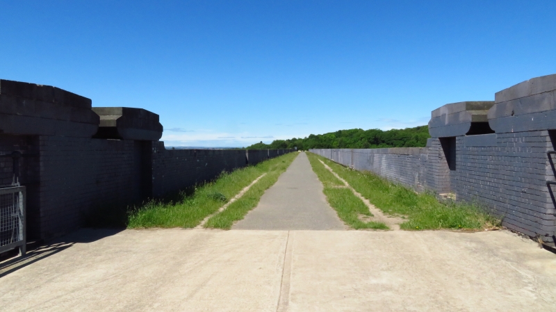
Railway viaduct, 1906 to 1909, brick construction, with a lattice girder river span.
Railway viaduct, 1906 to 1909, of brick construction, with a lattice girder river span.
MATERIALS: the main structure has a core of red bricks faced by two courses of Staffordshire blue engineering bricks, and the river-span is a lattice girder bridge.
PLAN: a double track, narrow rectangular plan 482.8m long viaduct, aligned west-by-north-west to east-by-south-east.
DESCRIPTION: the viaduct spans the River Don Valley, approximately 1.08km north-east of Conisbrough Castle, set between Foulsyke Wood and Nearcliff Wood, with the abutments blended into the valley sides. The viaduct is 482.8m (528yds) long and comprises 21 x 16.76m (55ft) round arches, ranging from 12.19m (40ft) to 35.05m (115ft) in height. There is a seven-arch arcade to the south of the river and two seven-arch arcades to the north, separated by a large double-pier, along with a double-pier situated to either side of the River Don. The arches rest on tapering rectangular section piers, with plain projecting impost bands and projecting drip moulds above. The parapet walls are carried on brick corbel tables and are copped with flat coping stones; refuges project out from the face of the wall above each of the piers, giving the appearance of brick posts. A pair of decorative brick buttresses project from the sides of each of the double-piers and are carried up to form posts, crowned by ashlar capstones that rise above the parapet wall; similar brick posts are situated at each end of the parapet walls. The double-piers to either side of the River Don have a projecting bedstones that support a 20-bay 45.72m (150ft) long Warren truss bridge, built of two parallel lattice girders, linked by transverse cross-bracing, beneath a metal bridge deck laid in concrete. The central six bays of each girder have longitudinal cross-bracing, while the six bays to either side have inclined bracing and the two end bays have double canted bracing. The sides of the open bridge deck are cantilevered out from the track bed and are protected by tall moulded cast-iron posts with flared bases, supporting three-bar tubular railings.
The Dearne Valley Railway was incorporated by an Act of Parliament on 6 August 1897, which authorised the building of a line between Brierley Junction and Doncaster. It was worked by the Lancashire and Yorkshire Railway and was opened in stages over a seven-year period, from 1902 to 1909; it was constructed principally to transport coal from a number of collieries along its route, including: Brierley, Grimethorpe, Houghton Main, Hickleton Main, Goldthorpe, Barnborough Main, and Denaby Main. The last section of line was completed in 1909; it included Conisbrough Viaduct and was designed by W Kaye of Leeds, built by Messrs Henry Lovatt Ltd of London and Manchester, under the supervision of Mr R H Clayton of Doncaster, the engineer of the Lancashire and Yorkshire Railway Company.
Along with the listed Grade II* Vauxhall Bridge, London (1906) (National Heritage List for England (NHLE): 1393011 and 1393012), the viaduct is notable as being one of the first bridges in England to be built using a Blondin aerial ropeway system. This system relied upon a cradle or gondola, which was suspended on cables between two stayed girder frames 571.5m (625yds) apart and was raised, lowered and winched back and forth by a static steam engine, to transport both men and materials; it allowed 2.72 tonnes (3 tons) of materials to be delivered from above, without having to be brought up laboriously through the formwork, from the valley floor below. It is believed that over 15 million bricks were used in its construction, many coming from local brickyards at Barnsley and Rotherham.
A passenger service was introduced in 1912, but it was withdrawn in 1951, leaving the railway as a goods line, and the viaduct was closed 15 years later, on 11 July 1966. The dis-used viaduct remained in the hands of British Rail Board until its ownership was transferred to Railway Paths Ltd, on behalf of the sustainable transport charity Sustrans in 2001. The viaduct had been used as an un-official path for some time; however, to enable an official use, the Railway Heritage Trust and Doncaster Council provided financial assistance to level the track-bed, a concrete surface was laid on the girder bridge and galvanized safety railings were installed. The viaduct was officially opened was in April 2008, becoming part of the Trans Pennine Trail and the National Cycle Network Route 62. There are two listed Grade II railway structures nearby, Conisbrough Tunnel East Portal (NHLE: 1192678), and West Portal (NHLE: 1314839).
Conisbrough Viaduct, completed 1909, designed by W Kaye of Leeds for the Dearne Valley Railway, is listed at Grade II for the following principal reasons:
Architectural interest:
* this viaduct is an elegant, well designed and well-built structure, executed in good quality materials;
* it is intact and unaltered, apart from minor interventions to conform with modern health and safety regulations, as part of its use as a cycle route;
* it is an early example of a large railway viaduct built using the innovative Blondin aerial ropeway system, to deliver both men and heavy materials from above;
* it illustrates the development and application of new building techniques to improve the efficiency of large-scale construction and engineering projects;
* it compares well with other contemporary listed viaducts.
Historic interest:
* it illustrates well the last phases of the Railway Age and the still expanding early C20 industrial economy of the United Kingdom, before the damaging economic effects of First World War and the Great Depression.
External links are from the relevant listing authority and, where applicable, Wikidata. Wikidata IDs may be related buildings as well as this specific building. If you want to add or update a link, you will need to do so by editing the Wikidata entry.


Other nearby listed buildings