Approximate Location Map
Large Map »
Latitude: 50.8728 / 50°52'22"N
Longitude: -1.3962 / 1°23'46"W
OS Eastings: 442578
OS Northings: 108318
OS Grid: SU425083
Mapcode National: GBR 888.7T8
Mapcode Global: FRA 76YS.RVX
Plus Code: 9C2WVJF3+4G
Entry Name: Hythe Pier
Listing Date: 17 August 2021
Grade: II
Source: Historic England
Source ID: 1476460
ID on this website: 101476460
Location: Hythe, New Forest, Hampshire, SO45
County: Hampshire
District: New Forest
Civil Parish: Hythe and Dibden
Built-Up Area: Hythe
Traditional County: Hampshire
Lieutenancy Area (Ceremonial County): Hampshire
Pier, built between 1879 and 1881, designed by James Wright and built by Bergheim of London for the Hythe Pier and Hythe and Southampton Ferry Company Ltd, with later additions and repairs.
Pier, built between 1879 and 1881, designed by James Wright and built by Bergheim of London for the Hythe Pier and Hythe and Southampton Ferry Company Ltd, with later additions and repairs.
Attached to the north side of pier is the footbridge* that leads down to the ferry stage pontoon*; both are modern replacements which are not included in the listing.
MATERIALS: the pier has a cast-iron and steel substructure, with timber-plank walkway and timber-clad waiting rooms.
PLAN: a long narrow pier, measuring just under 640m in length and orientated roughly north to south. There are waiting rooms and other structures at the north (seaward) end.
EXTERIOR: the main pier runs from the bank at Hythe (south end).
The pier SUBSTRUCTURE is principally a cast-iron and steel frame. At the south end the north side of the approach ramp is supported by two longitudinal girders spanning between concrete abutments on the east side and cast-iron columns west side. The rest of the pier construction consists of cast-iron columns which are braced latterly by vertical cross bracing and internal trusses. Spanning between the pairs of columns are two longitudinal steel lattice trusses which are joined in locations by expansion joints. Flanking the pier at two locations are the columns which supported the former interim landing stages (the timber planks have been removed in these areas).
Where the pierhead buildings are located, the structure widens and there are two additional outer rows of columns; the pier deck in this area is jettied and supported by cast-iron brackets. The north end is a later extension to the pierhead; the later columns appear to have been fixed to concrete bases constructed using steel sheet piles.
The pier SUPERSTRUCTURE has a timber-plank deck on wooden joists. The planks have been subject to various phases of replacement.
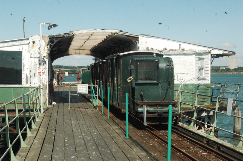
The pier railings are steel tubular rails with slanting stanchions. Most of the stanchions have been replaced in steel that match the style of original supports; on the east side there are some surviving cast-iron stanchions which may be original. The electric railway line runs along the east side of the pier; in this location since 1922, sections of railway track have been replaced at various stages. The lamp posts that line either side of the pier are late-C20.
At the pierhead end to the north are two rows of painted-timber buildings, they stand either side of the pier railway terminus which includes a raised timber platform covered by a canopy that joins the roofs of the flanking buildings. The station canopy and overhanging roof eaves on the seaward sides are supported by cast-iron brackets. The pier structure extends around either side of the buildings to create a walkway around the structures; the south side retains the walkway and railings while the north side is currently missing both.
Most of the buildings are clad in vertical timber. The section below the mid rail is backed by a tongue-and grooved boarding; most of the timber boarding which backed the upper level has been replaced by plate glass.
The east pierhead building includes the original 1880s building, with a lean-to at the north end. The seaward elevation has a series of sash windows and doorways which are inserted when this building was subdivided as part of the yacht club; several of the earlier sash windows have been replaced by picture windows. The platform elevations consists of a series of bays consisting of timber posts with stopped-and-chamfered cross bracing either side of a mid-rail. At the north end is the 1920s general room extension to the former yacht club; a timber-clad building with one-over-one sash windows on the seaward elevation, and further windows and doors on the south end and platform-side elevation.
The west building consists of the waiting room at the south end which is slightly later than the north end which contains the original toilets and pantry. The seaward elevation has eight-over-eight sash windows. The south elevation had a large picture window in an earlier opening. The southern half of the platform elevation is similar to the east building. The northern half of the west building’s platform elevation retains its tongue-and-groove boarding at both levels behind the cross bracing; there is also a large timber door that accesses the toilets and is flanked by decorative cast-iron brackets. At the north end is a modern lean-to.
At the pierhead are various later steel machinery and gantry.
INTERIOR: the late-C19 section of the east pierhead building (from south to north) consists of a long open space; all the later subdivisions which date to its use as a yacht club have been removed. It has a timber-boarded floor and ceiling. At the north end is the 1920s former yacht club general room. It has tongue-and-groove board walls and a coved boarded ceiling with an elliptical applied decoration.
The west pierhead building (from south to north) consists of a waiting room with a timber-boarded floor and ceiling, and walls lined with tongue-and-groove boards with a dado rail. Beyond, through a later internal door, is the kitchenette (former pantry), with a similar boarded ceiling and floor. Further north is the former ladies’ toilets; the room retains original cubicles with privacy latches and the cubicle doorways are topped by louvered ventilation panels. There are also some early cisterns and a corner basin. The walls are clad in tongue-and-groove boards. The ceiling has been covered by later timber boards.
* Pursuant to s1 (5A) of the Planning (Listed Buildings and Conservation Areas) Act 1990 (‘the Act’) it is declared that these aforementioned features are not of special architectural or historic interest. However, any works to these structures and/or features which have the potential to affect the character of the listed building as a building of special architectural or historic interest may still require Listed Building Consent (LBC) and this is a matter for the Local Planning Authority (LPA) to determine.
Since at least the late C16 ferries and boats have operated from around a gravel hard at Hythe. In 1830 the first passenger steamer ferry was advertised operating between Hythe and Southampton, run by a company led by Mr WC Westlake.
In 1870 a Bill was submitted to Parliament for the construction of a pier to replace the existing gravel hard. Royal Assent for the pier was eventually granted in 1878. The Hythe Pier and Hythe and Southampton Ferry Company Ltd (established in 1874), began construction of the 2100ft (640m) long pier in 1879. It was designed by James Wright and built by Berghiem of London. In addition an area of land was adopted to form an approach to the pier, including the provision of a tollhouse located to the south side of the pier (the former tollhouse was not assessed). The official opening ceremony was held on 1 January 1881, performed by the Mayor of Southampton.
By the 1890s, the north end of the pier was flanked by a pair of timber-clad waiting rooms and facilities, including toilets and pantry in the building on the north side. The principal ferry docking point was at the east end with stairs leading down to a lower level for embarkation. There were also further interim landing stages, later furnished with shelters, located along the length of the pier which could be used at high tide. In 1894 the Hythe Sailing Club was allowed to establish a clubhouse in the existing building on the east side of the pierhead, subdividing the space for various club facilities including sleeping compartments. At around this time the western building was extended to the north providing a new waiting room for ferry users. In 1896 £1500 was spent on the pier, including a complete re-planking by Roe and Grace of Southampton. In 1921 the Club added a further northern extension to their clubhouse with the addition of a general room.
The 1870s plans for the pier had allowed for a railway to operate along the centre of the pier deck, but these had not been taken forward in the final design. In 1909 track and sidings were laid down for running a hand propelled luggage trolley along the piers west side. In 1922 this was replaced by a narrow-gauge electric railway, on the third-rail system, installed along the east side to facilitate the transport passengers and their luggage to the ferry landing stage. It is understood that the train service, which is still in operation, is the oldest continuously-operating pier train in the world. In around the 1920s a ticket office and parcel office was added to the landward end of the pier, replacing the original tollhouse (which became a pier office), as was a workshop for the maintenance of the new pier train; these buildings flanked a small maintenance yard and passenger platform.
By 1932 a pontoon had been added to the north end of the pier for use as the ferry landing stage and linked to the main pier structure by a footbridge. During the Second World War an Anti-Aircraft searchlight (no longer extant) was added to the roof of one of the north-end buildings. On 24 May 1944, in advance of the D-Day landings, King George VI landed at Hythe Pier while travelling between inspections of HMS Squid, the shore based Combined Operation Base at Southampton, and the Broadlands Estate, Romsey where many British and American soldiers were encamped. The pier was lined with sailors. Upon landing at the pierhead, His Majesty was met by a small landing party and travelled on the pier train to the landward end where he was received by a larger party before being taken by car to Broadlands. A commemorative plaque was placed in the carriage which had been ridden by King George; the plaque was later stolen.
In 1947 the pierhead went through some reconstruction, including the movement of the pontoon further away from the pierhead and a replacement footbridge (the mid-C20 bridge and pontoon were replaced again later). In the early 1960s the pier’s land-side entrance was ‘modernised’; at around this time the interim landing stage shelters along the pier were removed.
The pier has been subject to piecemeal repairs throughout its history, many due to damage suffered through vessel collisions, one of the most recent being in 2016.
Hythe Pier, New Forest, Hampshire is listed at Grade II for the following principal reasons:
Architectural interest:
* for the good survival of the late-C19 substructure including the pairs of slender cast-iron columns and the cross bracing;
* for the late-C19 and early-C20 pierhead buildings which, although relatively modest in scale and design, show good attention in their architectural detailing.
Historic interest:
* it continues to be an evocative example of late-C19 ferry travel;
* it illustrates well the changing requirements and expectations of ferry passengers, including the addition of the 1920s rail track understood to be the oldest continuously operating pier train in the world.
External links are from the relevant listing authority and, where applicable, Wikidata. Wikidata IDs may be related buildings as well as this specific building. If you want to add or update a link, you will need to do so by editing the Wikidata entry.


Other nearby listed buildings