Approximate Location Map
Large Map »
Latitude: 55.7639 / 55°45'49"N
Longitude: -3.9654 / 3°57'55"W
OS Eastings: 276779
OS Northings: 654027
OS Grid: NS767540
Mapcode National: GBR 01RS.9N
Mapcode Global: WH4QY.1DZ6
Plus Code: 9C7RQ27M+GR
Entry Name: Enclosure and Mausolea, St Michael's Graveyard, Cambusnethan
Listing Name: Wishaw, Netherton, Kirkhill Road, St Michael's Churchyard, Enclosure and Mausolea
Listing Date: 21 June 1982
Category: B
Source: Historic Scotland
Source ID: 330260
Historic Scotland Designation Reference: LB64
Building Class: Cultural
ID on this website: 200330260
Location: Cambusnethan
County: North Lanarkshire
Electoral Ward: Motherwell South East and Ravenscraig
Parish: Cambusnethan
Traditional County: Lanarkshire
Tagged with: Architectural structure
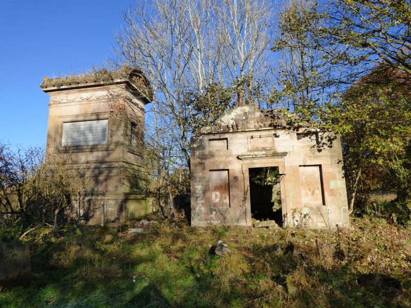
CEMETERY: on medieval site of Cambusnethan Parish Church and churchyard, in use until circa 1650. Levelled and elevated, rectangular site; collapsed rubble boundary wall, entrance on N wall.
MAUSOLEA: mid 18th to mid 19th century, 3 adjoining rectangular-plan burial enclosures, arranged in L-plan, incorporating stonework of medieval Cambusnethan Parish Church. Ruinous and roofless.
S ENCLOSURE: mid 18th century, single storey, 3-bay, rectangular-plan, classical, Coltness mausoleum.
S (PRINCIPAL) ELEVATION: diagonally droved ashlar yellow sandstone. lugged, architraved and corniced doorway to centre, flanking blind windows, rope-moulded panel above inscribed 'Coltness', flanked by blind attic windows; ruinous gable; blank returns.
N ENCLOSURE: probably mid 19th century, single storey, 3-bay, rectangular-plan, Lockhart Mausoleum. Droved ashlar yellow sandstone.
E (PRINCIPAL) ELEVATION: wide central opening, flanking blind windows; blank returns. Ruinous above wallhead.
W ENCLOSURE: rectangular-plan, ruinous, base course only.
The churchyard is the remains of the original Cambusnethan Parish Church founded by St Nethan in the 8th century. Later becoming St Michael's before the Reformation when the church was moved up to the village. It is close to the site of the original Cambusnethan House which belonged to the Baird family in the Medieval period, succeeding to the Stevensons (Lockhart of Castlehill) in the 17th century. The mausolea that have been built since the move up to the village in that century represent the estates that the original Cambusnethan Baird owned land was broken up into, ie Belhaven's of Wishaw, the Stewarts of Coltness and the Lockharts of Castlehill. Coincidentally all three estates had houses by James Gillepsie Graham, though all are now in various states of ruin. The largest tomb, the Belhaven and Stenton mausoleum, is listed separately.
External links are from the relevant listing authority and, where applicable, Wikidata. Wikidata IDs may be related buildings as well as this specific building. If you want to add or update a link, you will need to do so by editing the Wikidata entry.


Other nearby listed buildings
