Approximate Location Map
Large Map »
Latitude: 55.9574 / 55°57'26"N
Longitude: -4.5887 / 4°35'19"W
OS Eastings: 238483
OS Northings: 676845
OS Grid: NS384768
Mapcode National: GBR 0L.XM3V
Mapcode Global: WH3NJ.HJ3B
Plus Code: 9C7QXC46+XG
Entry Name: Mains Lodge, Dalmoak House
Listing Name: Renton, Dalmoak House, Mains Lodge with Gates, Gatepiers and Boundary Wall
Listing Date: 8 September 1980
Category: B
Source: Historic Scotland
Source ID: 331656
Historic Scotland Designation Reference: LB1163
Building Class: Cultural
Also known as: Dalmoak House, Mains Lodge
ID on this website: 200331656
Location: Cardross
County: West Dunbartonshire
Electoral Ward: Leven
Parish: Cardross
Traditional County: Dunbartonshire
Tagged with: Gatehouse Architectural structure
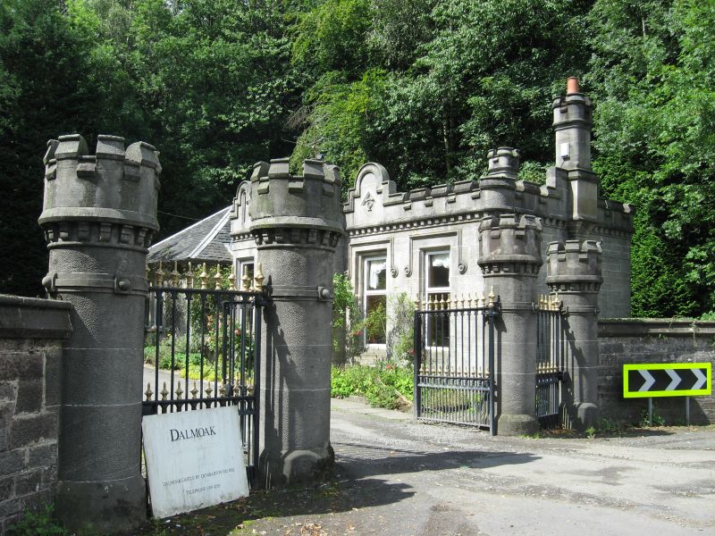
1866-1869, with later piend-roofed abutting at rear. Single storey, rectangular-plan castellated Tudor gothic lodge; stugged squared and snecked ashlar with ashlar margins and dressings; rendered addition. Crenellated, billeted parapet rising into round-headed panels at intervals. Hoodmoulds, labelstops.
S (MAIN) ELEVATION: 3-bay original block with piend-roofed later addition to left. Main lodge with 2 windows symmetrically disposed to right, parapet raised over centre window, monogram. Canted bay to left in slightly advanced bay with curved corners.
E (ROAD) ELEVATION: plaque depicting Greek cross and shield at centre, hoodmould; corbelled stack breaking blocking course.
uPVC top-hopper windows. Slate roof, lead flashings. Tall ridge and wallhead stacks with rounded corners and crenellated coping.
INTERIOR: not seen 1995.
GATES GATEPIERS AND BOUNDARY WALL: gate at centre framed by pedestrian gates. Circular pier with corbelled crenellated caps; ring band. Squat square-plan terminating piers.
GATES: finialled cast-iron gates with gilded tips.
BOUNDARY WALL: squared and snecked, stepped rubble wall with harl/ cement pointing; ashlar gablet coping.
Dalmoak House was built by James Aitken. The house, stables, walled garden and W gatepiers are listed separately.
External links are from the relevant listing authority and, where applicable, Wikidata. Wikidata IDs may be related buildings as well as this specific building. If you want to add or update a link, you will need to do so by editing the Wikidata entry.


Other nearby listed buildings
