Approximate Location Map
Large Map »
Latitude: 56.0358 / 56°2'8"N
Longitude: -3.5034 / 3°30'12"W
OS Eastings: 306422
OS Northings: 683561
OS Grid: NT064835
Mapcode National: GBR 1W.RQX8
Mapcode Global: WH5QY.4KZ8
Plus Code: 9C8R2FPW+8J
Entry Name: Charlestown, Harbour Road, Limekilns
Listing Date: 31 December 1971
Category: A
Source: Historic Scotland
Source ID: 334871
Historic Scotland Designation Reference: LB3741
Building Class: Cultural
Also known as: Charlestown, limekilns and associated features
ID on this website: 200334871
Location: Dunfermline
County: Fife
Electoral Ward: Rosyth
Parish: Dunfermline
Traditional County: Fife
Tagged with: Lime kiln Lime works
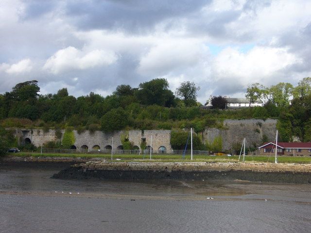
1750-1760. Long range of 14 kilns, inter-connected by rear passage, approximately 30 foot high. Principal elevation faces S towards harbour; rear built into bank. Coursed, dressed sandstone. Kilns numbered 1 from E to 14 at W. Tall (approximately 30 foot) sloping wall runs northwards at far right; concave area to left; raggles of pitched buildings (now gone); tall red brick flue with fireplace at base extends height of wall. Openings to kilns to left. Row of 10 arches to left. First 3 arches set back due to missing stone facing. Large square opening above and between 2nd and 3rd arch. Timber boarded doors cover first 3 arches. Stone facing missing to left of 9th arch. Fireplace in arch to left of 10th arch. Tall access archway to left of Kiln 11. Kiln 12 advanced and set at angle to left; 2 arches in right return. Low arch with fireplace to right of Kiln 12; tall access arch to left. Advanced Kiln 13 to left; 2 small arches in right return. Low arch with fireplace set in to left; tall access archway to left; opening above to right. Kiln 14 to far left; low archway to right; flat segmental arch to far left; opening above. Slope to left gives access to left return of Kiln 14.
SCHEDULED MONUMENT. A-Group with 1-90 Charlestown Village, exluding 36-37 and 52-55 Charlestown Village; Charlestown, Bridge of Former Elgin Railway; Charlestown, Camsie House; Charlestown Harbour; Charlestown Village, K6 Telephone Kiosk; Charlestown Village, The Queen's Hall; Charlestown, 8, 10, 14, The Sutlery, 16, 18 Rocks Road; Charlestown, 12 Rocks Road, The Old School House; Charlestown, Rocks Road, Former Estate Workshop and Charlestown, Rocks Road, Old School. Limestone had been dug and burnt in kilns at Limekilns before Charles, 5th Earl of Elgin organised the process. Lime played an important part in Scotland's economy and was used in agriculture, building and industrial applications such as glass production. Coal and limestone were found on the Elgin estate which the Earl exploited to create a large industry which also involved the establishment of an iron foundry, brick works, the export of coal and coke as well as lime, a village to house the workers and the necessary transport for the materials which included wagonways and the harbour. Initially 6 kilns were built (at the E end of the bank) which later increased to 14 as Charlestown became the largest producer of lime in Europe and supplied a third of Scotland's total production. It was one of the first large-scale industrial enterprises in Scotland. The limestone was transported by horse drawn carts and later by wagons to the kilnhead. Due to the position of the kilns built into the bank, the need to hoist coal up to the kilnhead was eliminated and the proximity of the kilns to the harbour enabled the men to shovel the lime directly onto the boats for exportation. Associated structures such as the slaking house and engineer's shed were demolished in 1956 when the works closed. The kilns operated for over 200 years and are now redundant. The scale of the limekilns which remain serve as a reminder of the industry which created Charlestown and its importance is enhanced by the survival of the associated village, harbour, quarries and rail tracks.
External links are from the relevant listing authority and, where applicable, Wikidata. Wikidata IDs may be related buildings as well as this specific building. If you want to add or update a link, you will need to do so by editing the Wikidata entry.


Other nearby listed buildings
