Latitude: 55.0844 / 55°5'3"N
Longitude: -3.6097 / 3°36'34"W
OS Eastings: 297344
OS Northings: 577846
OS Grid: NX973778
Mapcode National: GBR 397N.95
Mapcode Global: WH5WJ.JG9K
Plus Code: 9C7R39MR+Q4
Entry Name: Martinton Bridge
Listing Name: Martinton Bridge (Railway Viaduct over River Nith)
Listing Date: 26 June 1986
Category: B
Source: Historic Scotland
Source ID: 334987
Historic Scotland Designation Reference: LB3832
Building Class: Cultural
ID on this website: 200334987
Location: Dumfries
County: Dumfries and Galloway
Electoral Ward: Lochar
Parish: Dumfries
Traditional County: Dumfriesshire
Tagged with: Bridge Railway bridge
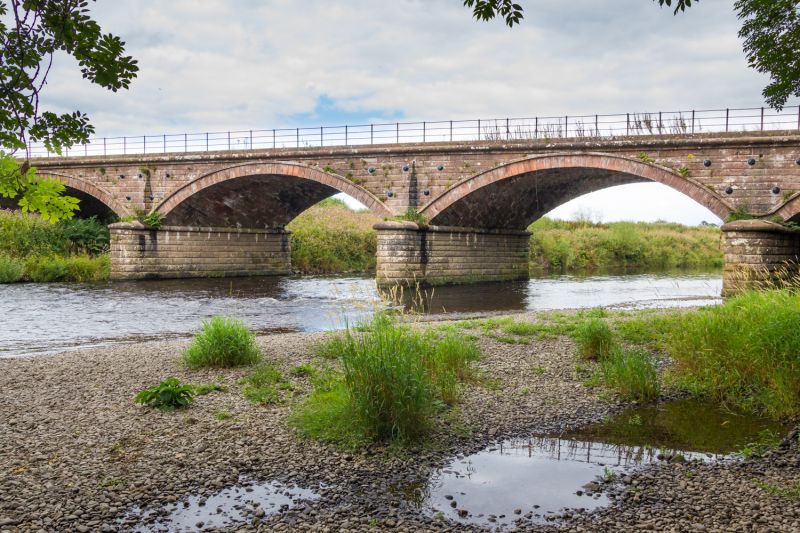
Dumfries-Closeburn line, John Miller Engineer, opened
15.10.1849. Railway viaduct carrying double tracks; 3 wide,
skewed segmental arches over River Nith, 7 smaller arches on
low north bank, narrow round-headed pedestrian archway to
south. All built of red sandstone; wide arches, channelled
bullfaced ashlar, piers with cutwaters; rusticated voissoirs,
outer pilaster strips linked by continuous string; iron
handrail. Smaller arches to north built of squared rubble,
with ashlar dressings and band below parapets.
Also in Holywood Parish.
External links are from the relevant listing authority and, where applicable, Wikidata. Wikidata IDs may be related buildings as well as this specific building. If you want to add or update a link, you will need to do so by editing the Wikidata entry.


Other nearby listed buildings