Approximate Location Map
Large Map »
Latitude: 55.8039 / 55°48'13"N
Longitude: -2.341 / 2°20'27"W
OS Eastings: 378720
OS Northings: 656783
OS Grid: NT787567
Mapcode National: GBR D12B.Z9
Mapcode Global: WH8X2.0DH1
Plus Code: 9C7VRM35+GH
Entry Name: Preston Bridge
Listing Name: Preston Bridge
Listing Date: 9 June 1971
Category: A
Source: Historic Scotland
Source ID: 335348
Historic Scotland Designation Reference: LB4120
Building Class: Cultural
ID on this website: 200335348
Location: Bunkle and Preston
County: Scottish Borders
Electoral Ward: Mid Berwickshire
Parish: Bunkle And Preston
Traditional County: Berwickshire
Tagged with: Road bridge
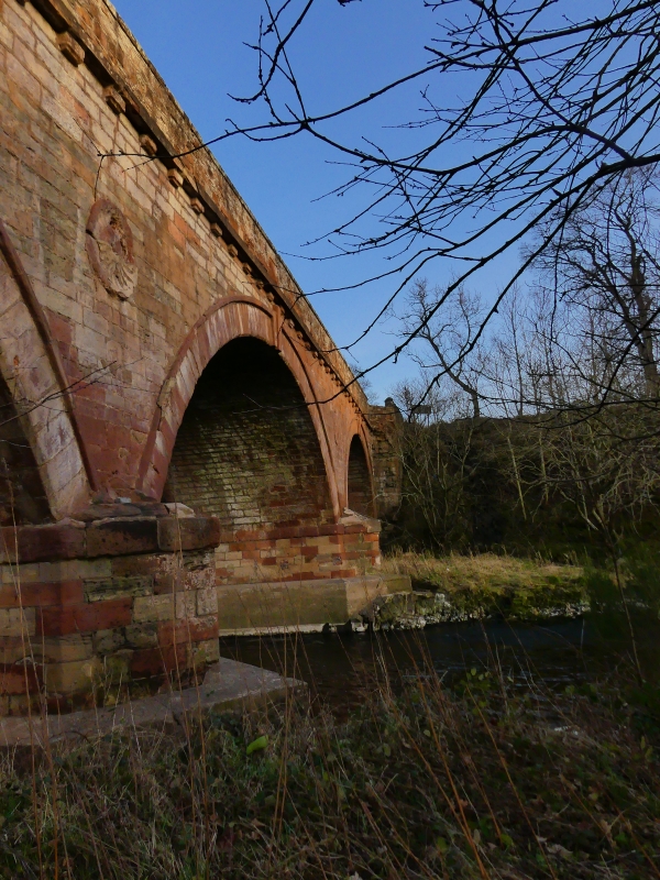
Dated 1770 with later repairs. 3-arched, humped-back bridge, in style of William Adam, spanning Whiteadder Water (largest arch at centre). Pointed red sandstone rubble to parapets; coursed and squared red sandstone rubble to spandrels; sandstone ashlar dressings. Segmental-arched openings with flush voussoirs; raised outer bands with central keystones (that to S, to outer left dated '1770'); coursed rubble soffits and abutments. Empty circular niches centred in spandrels to N; carved floral detail in niches to S. Mutuled string courses beneath coped parapets; weathered, square-plan panels aligned above keystones. Coursed sandstone cutwaters with stepped bases flanking central opening. Buttressed wing walls at either end; further rubble-coped, rubble walls to E; circular-plan terminating piers to W.
One of the most prominent landmarks in the parish, this "...handsome stone bridge" (OS Name Book) spans the boundary between Bunkle & Preston and the adjoining parish of Duns. Dated 1770, much of the original detailing remains intact - the spandrel niches, mutuled string courses and keystoned arches being particularly notable. See separate list entry for the similarly detailed Todheugh Bridge.
External links are from the relevant listing authority and, where applicable, Wikidata. Wikidata IDs may be related buildings as well as this specific building. If you want to add or update a link, you will need to do so by editing the Wikidata entry.


Other nearby listed buildings
