Approximate Location Map
Large Map »
Latitude: 55.7499 / 55°44'59"N
Longitude: -3.3564 / 3°21'22"W
OS Eastings: 314959
OS Northings: 651562
OS Grid: NT149515
Mapcode National: GBR 510Y.4N
Mapcode Global: WH6TH.DQZW
Plus Code: 9C7RPJXV+XF
Entry Name: Toll House, Main Street, West Linton
Listing Name: West Linton, Former Toll House
Listing Date: 1 March 1978
Category: C
Source: Historic Scotland
Source ID: 340462
Historic Scotland Designation Reference: LB8355
Building Class: Cultural
ID on this website: 200340462
Location: West Linton
County: Scottish Borders
Electoral Ward: Tweeddale West
Parish: West Linton
Traditional County: Peeblesshire
Tagged with: Tollhouse
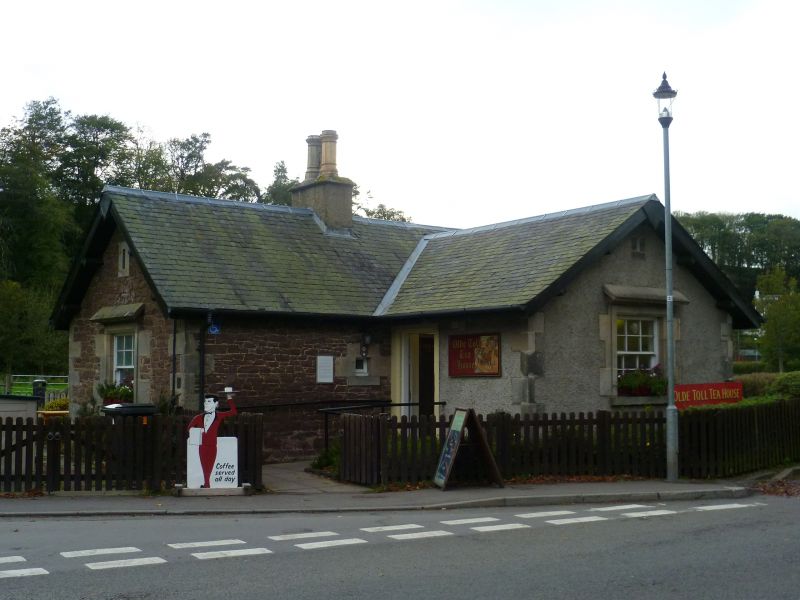
Core possibly late 18th century with later additions (see Notes). Single-storey, T-plan, gabled former toll house cottage with overhanging eaves, occupying prominent location village. Roughly squared and snecked rubble with sandstone ashlar dressings. Small 'wicket' opening beside doorway. Pitched hoodmoulds over main windows with small rectangular indents above to gable ends. Bracketted eaves with timber bargeboarding.
12-pane glazing to wide timber sash and case windows. Grey slate; ridge stack with octagonal cans.
The diminuitive West Linton toll house is prominently located on an important pulse point on the former Edinburgh to Moffat road. The building is characterised by its overhanging eaves and pitched hoodmoulds to its large observation windows to N and S, and the small toll window or 'wicket' near the entrance. Originally of simple rectangular plan, extended to E and again to W during the late 20th century, the building retains a sense of its former identity and function, adding to the architectural and historic interest of the streetscape.
Linton Toll House was the first encountered on entering Peeblesshire from the North and a ticket purchased here exempted the traveller from any further tolls within the county. Currently in use as a tearoom (2010).
List description updated at resurvey (2010).
External links are from the relevant listing authority and, where applicable, Wikidata. Wikidata IDs may be related buildings as well as this specific building. If you want to add or update a link, you will need to do so by editing the Wikidata entry.


Other nearby listed buildings
