Approximate Location Map
Large Map »
Latitude: 57.2227 / 57°13'21"N
Longitude: -3.0356 / 3°2'8"W
OS Eastings: 337565
OS Northings: 815132
OS Grid: NJ375151
Mapcode National: GBR L9WM.L4Y
Mapcode Global: WH7MM.BQQD
Plus Code: 9C9R6XF7+3Q
Entry Name: Church, Kirkton Of Glenbuchat
Listing Name: Old Parish Church (Church of Scotland)
Listing Date: 16 April 1971
Category: A
Source: Historic Scotland
Source ID: 341380
Historic Scotland Designation Reference: LB9126
Building Class: Cultural
Also known as: Kirkton Of Glenbuchat, Church
ID on this website: 200341380
Location: Glenbuchat
County: Aberdeenshire
Electoral Ward: Aboyne, Upper Deeside and Donside
Parish: Glenbuchat
Traditional County: Aberdeenshire
Tagged with: Church building
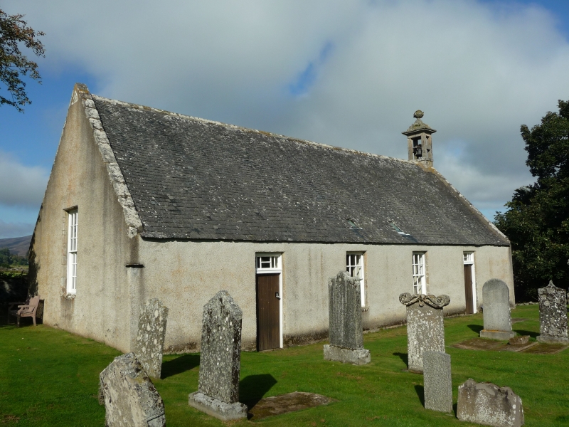
Dated 1629, rebuilt 1792 and possibly incorporating 1473 fabric; laird's loft added 1828, gable windows possibly of same date. Simple, unaltered, rectangular-plan, aisless church with 4-bay nave and gablehead belfry retaining bell dated 1643. Harled (concrete harl to blank N elevation) with deep-set, square-headed openings, stone margins and chamfered arrises.
Further Description:
S (ENTRANCE) ELEVATION: symmetrical. 2 windows to centre with doors to flanking bays, each door vertically-boarded with ironwork handle and decoratively-astragalled fanlight; 2 diminutive rooflights close to wallhead at centre. Small flat stone (possibly for sundial) projecting high up at outer left angle.
E AND W ELEVATIONS: gabled elevations, each with tall centre window. E gable with urn-finialled stone belfry (see Notes); moulded triangular panel to apex of W gable with 'M A K 1629'.
Multi-pane glazing patterns in timber sash and case windows. Graded grey slates. Ashlar-coped skews.
INTERIOR: rare survival of unaltered interior with pulpit at centre of S wall, simple fixed pews to remaining sides with box pews to N incorporating communion tables, and manse pew (also box) to E; later E gallery with square marbled centre column and panelled front with Lord Fife's coat of arms. Floor cobbled beneath box pews, dirt floor elsewhere; passageways laid with Correen stone. Coomb ceiling (see Notes) with 2 small rooflights to south. WWI memorial from former Free Church, and classical marble memorial to Farquharsons of Badenyon.
Ecclesiastical building in use as such, annual service held on the third Sunday in August. Group with Old Parish Church Graveyard and Manse. The Old Church is a rare survival of a traditional church with original interior described as 'a model of primitive but comely decency' in The Book of Glenbuchat (p14). The only later additions being the fine laird's loft and war memorial panels. The building measures 57'4' x 26'9' and the initialled datestone at the west gable commemorates 'M A K', Master Andrew Kerr who was the minister of Glenbuchat from 1618 until 1633. The bellcote was repositioned from the west gable in or around 1857 by David Wood, mason of Kildrummy. The 1643 bell bears the name of Dutch bellfounder, Peter Jansen. The Book of Glenbuchat considers the question of date by careful examination of the stonework, it states 'The dressed stones of the doors and windows in the south side are wrought in yellow Kildrummy freestone, and bear the 'bull-nosed' or rounded arris so frequently found in the castle. Doubtless these stones date from the building of 1629, and were re-used in the later reconstruction. ' but the lower courses on the south side are of squared rubble, and seem older than the rest of the fabric' (p14). It is also possible that the ceiling shape (irregular coving) may camouflage early construction detail as The Book of Glenbuchat refers to the end of the 18th century when 'the church was covered in heather, and the couples were exposed inside' (p15). The building is currently (2006) kept wind and watertight by the local authority, and was restored in 1964. The concrete harl was probably applied to the north elevation at that time.
External links are from the relevant listing authority and, where applicable, Wikidata. Wikidata IDs may be related buildings as well as this specific building. If you want to add or update a link, you will need to do so by editing the Wikidata entry.


Other nearby listed buildings
