Approximate Location Map
Large Map »
Latitude: 56.8139 / 56°48'50"N
Longitude: -3.4611 / 3°27'40"W
OS Eastings: 310896
OS Northings: 770109
OS Grid: NO108701
Mapcode National: GBR KBTQ.387
Mapcode Global: WH5M2.TZ1R
Plus Code: 9C8RRG7Q+HG
Entry Name: Glenshee Bridge carrying former military road over Shee Water, excluding 20th century railings, Spittal of Glenshee, Glenshee
Listing Name: Glenshee Bridge carrying former military road over Shee Water, excluding 20th century railings, Spittal of Glenshee, Glenshee
Listing Date: 5 October 1971
Last Amended: 9 February 2021
Category: A
Source: Historic Scotland
Source ID: 344077
Historic Scotland Designation Reference: LB11489
Building Class: Cultural
Also known as: Spittal Of Glenshee, Shee Water, Glenshee Bridge
ID on this website: 200344077
Location: Kirkmichael (Perth & Kinross)
County: Perth and Kinross
Electoral Ward: Blairgowrie and Glens
Parish: Kirkmichael (Perth & Kinross)
Traditional County: Perthshire
Tagged with: Bridge
In accordance with Section 1 (4A) of the Planning (Listed Buildings and Conservation Areas) (Scotland) Act 1997 the following are excluded from the listing: 20th century railings.
Historical Development
There was an estimated total of 1700km of military road built in Scotland (approximately 400km by General Wade and 1300km by Major Caulfeild) between the early 1720s and the late 1750s.
The first programmes of work started in 1725 Under Wade's command, Repairs were made to various fortifications including Edinburgh Castle and at Fort William and new forts were built at Inverness (Fort George) and Killihuimen (Fort Augustus). Road communications and connections were improved between the garrisons at Fort William, Fort Augustus and Fort George. The roads programme then focused on expanding the network between Dunkeld and Inverness (later known as 'The Great North Road') with branches connecting Crieff to the Great North Road at Dalnacardoch (later known as 'The Second Great North Road') and Fort Augustus to the Great North Road at Dalwhinnie. The second major programme of works was overseen by Wade's successor, Major William Caulfeild, with branches constructed, from 1741 onwards, between: Crieff and Stirling, an incomplete build between Dumbarton and Inverary, Stirling to Fort William, Coupar Angus to Fort George, and Amulree to Dunkeld.
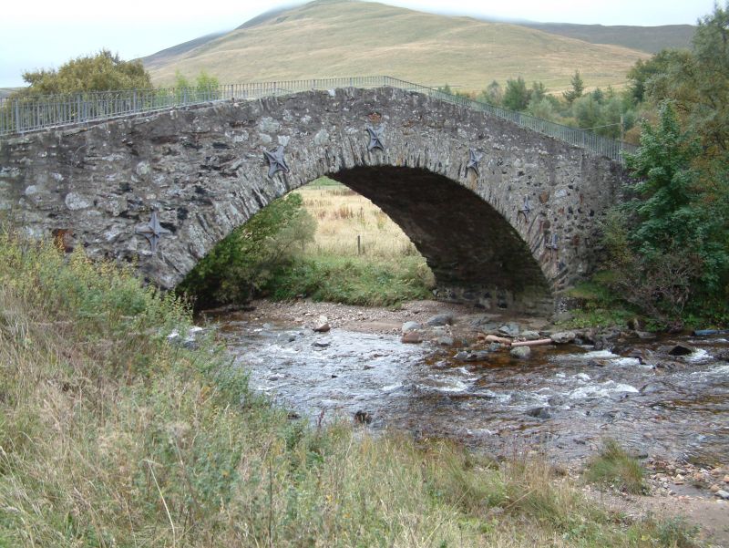
This bridge relates to the Braemar to Blairgowrie military road route and was likely constructed as part of this longer road programme, between 1749 and 1763. The bridge appears largely unaltered with evidence of metal pinning and stone / mortar conservation works.
The Glenshee bridge meets the criteria of special architectural or historic interest for the following reasons.
In accordance with Section 1 (4A) of the Planning (Listed Buildings and Conservation Areas) (Scotland) Act 1997 the following are excluded from the listing: 20th century railings.
Architectural Interest
Design
The bridge has the characteristic design of military bridges built as part of the 18th century road building programme under Major William Caufeild. These bridges were designed to be built quickly, usually by soldiers of various British Army regiments or contracted groups of local men. They were built using locally available materials and often the same formwork was reused for efficiency. They were specifically designed to accommodate heavy loads including troops, horses and wagons. Their functional purpose is reflected in their relatively plain design, which features no decorative stonework or embellishments. This was typical of stone-built bridges of the period.
This bridge is a largely unaltered and relatively large-scale example of a Caulfeild bridge showing a simple and characteristic hump-backed profile. It formed part of a much wider network of military roads and bridges. The fabric and plan form are relatively unchanged. It is estimated that 940 bridges were constructed as part of this network, however, the majority of these have been extensively altered or are of less interest in terms of their design and scale.
Age and Rarity
Although surviving examples of 18th century bridges are not particularly rare in Scotland, the bridge is important as it is a largely unaltered example of its date and type and forms part of a larger military network that has had a lasting impact on both the culture and physical landscape of the Scottish Highlands. The survival of this bridge compliments other elements of the wider road network in this area notably, the line of the military route from Blairgowrie to Braemar. The relationship between these elements add to the special interest of this bridge.
Social historical interest
The bridge is of social historical interest, as the large-scale military building programme under which it was built, had a significant impact on Highland culture. As a result of the 1715 Jacobite rising, the government saw the discontent towards the Hanoverian rule and began to impose control by constructing town and city garrisons and building permanent barracks.
After Culloden, Caulfeild's road building programme continued in a much larger scale to further assert Hanoverian control in Scotland. Some 15,000 government troops were stationed in Scotland and Caulfeild was assigned engineers and large numbers of men to work on the roads. This increase in control of the Highlands is linked to the period of severe Government repression after Culloden which saw Highland culture repressed and the clan system dismantled.
Association with people or events of national importance
The bridge has close historical associations with people of national importance. In 1724, General Wade was instructed to "narrowly inspect the situation of the Highlands" (Salmond, 42). In same year, Wade reported back to the King and was thereafter appointed as Commander of Forces in Northern Britain. He was succeeded in 1739 by Major William Caulfeild, who was appointed Inspector of Roads. Caulfeild had previously worked under Wade as a young officer and was then appointed Inspector of Roads.
Further association with these roads is indicated in their use by Bonnie Prince Charlie and during the Jacobite forces during the uprising of 1745. Wade's roads into the Highlands were utilised by the government forces but also had the unseen consequence of allowing the Jacobite army to move quickly into the Lowlands. When moving back into the Highlands in 1746, Bonnie Prince Charlie sent his troops on the Crieff to Dalnacardoch road and sent the artillery along the easier Dunkeld to Inverness road. Both the Jacobite and British forces continued to use the Great North Road and Second Great North Road until defeat of the Jacobite forces at Culloden in April 1746.
Statutory address, category of listing and listed building record revised in 2021. Previously listed as 'Glenshee bridge over Shee Water'.
External links are from the relevant listing authority and, where applicable, Wikidata. Wikidata IDs may be related buildings as well as this specific building. If you want to add or update a link, you will need to do so by editing the Wikidata entry.


Other nearby listed buildings
