Approximate Location Map
Large Map »
Latitude: 55.4837 / 55°29'1"N
Longitude: -2.5399 / 2°32'23"W
OS Eastings: 365976
OS Northings: 621230
OS Grid: NT659212
Mapcode National: GBR B5P1.X2
Mapcode Global: WH8YH.YFPH
Plus Code: 9C7VFFM6+F2
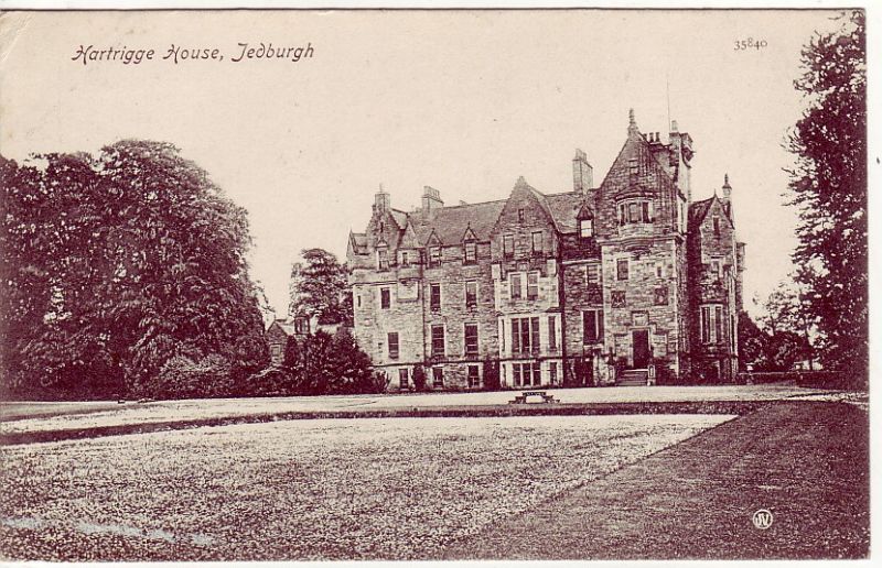
Entry Name: Hartrigge House
Listing Name: Hartrigge House Stables and Walled Garden
Listing Date: 2 December 1993
Category: B
Source: Historic Scotland
Source ID: 346503
Historic Scotland Designation Reference: LB13374
Building Class: Cultural
ID on this website: 200346503
Location: Jedburgh
County: Scottish Borders
Electoral Ward: Jedburgh and District
Parish: Jedburgh
Traditional County: Roxburghshire
Tagged with: Country house
Probably David Bryce, 1854; later additions and alterations. Disused Baronial stable block, part of which now converted to 2 homes. U-plan court linked to parallel range to rear. Squared and snecked stugged cream sandstone rubble; ashlar dresssings; formerly partly limewashed, traces remaining.
PRINCIPAL COURT: NE (REAR) RANGE: symmetrical courtyard elevation; 3 segmental-arches of coach house with 2-leaf boarded doors; flanked by pend to left and flat-panelled door with 3-pane fanlight to right. Converted hayloft above; blank plaque at centre with segmental-headed open pediment breaking eaves; flanking windows with gabled dormerheads. Irregular rear elevation with flanking crowstepped gables; later single-storey range adjoined to E.
NW (LEFT) RANGE: irregular courtyard elevation; to right, niche and segmental-headed carriage arch with louvred wallhead dormer above; small open pediment to raised wallhead at centre. Decorative outer elevation (facing drive), with pair of projecting 2-storey crowstepped gabled bays; round stairtower in re-entrant angle to left of right gable with tall candle-snuffer roof, fish-scale tiles and ball finial. Crowstepped gable to SW with blind window at ground and blank plaque above.
SE (RIGHT) RANGE: stable range with symmetrical courtyard elevation; 4 windows with half-shutters, 3 flat-panelled doors between; pair of louvred wallhead dormers to hay-loft above and pair of pagoda ventilators at apex. Irregular plain outer elevation with unfortunate modern conservatory added to NE. Gable to SW as above. Some stalls remain.
RANGE TO REAR: irregular single storey range with crowstepped gable ends converted to dwelling; 7 bays to outer (NE) elevation; lower gable shed added to NW end; pair of projecting gable ranges added to SW at cente; much altered lower single storey link to main block at W end.
Court closed to SW by saddleback coped wall with pair of square ashlar corniced gatepiers at centre.
Originally 12-pane timber sash and case windows; converted areas with unfortunate modern plate glass windows. Grey slates; dressed rubble stacks; crowstepped gables with beak skewputts.
WALLED GARDEN: to E; coped rubble wall. Sections in dilapidated condition.
The house is now demolished, but was built by Bryce in 1854. The stables presumably date from the same time. Lodges survive at Wildcat Gate in the parish, and Waterside in the burgh (see separate listings).
External links are from the relevant listing authority and, where applicable, Wikidata. Wikidata IDs may be related buildings as well as this specific building. If you want to add or update a link, you will need to do so by editing the Wikidata entry.


Other nearby listed buildings
