Approximate Location Map
Large Map »
Latitude: 55.0565 / 55°3'23"N
Longitude: -3.2516 / 3°15'5"W
OS Eastings: 320144
OS Northings: 574271
OS Grid: NY201742
Mapcode National: GBR 59QZ.T6
Mapcode Global: WH6Y1.05WG
Plus Code: 9C7R3P4X+H8
Entry Name: Mein Bridge
Listing Name: Mein Bridge (Formerly A74 over Mein Water - Now By-Passed)
Listing Date: 4 October 1988
Category: B
Source: Historic Scotland
Source ID: 350796
Historic Scotland Designation Reference: LB16961
Building Class: Cultural
ID on this website: 200350796
Location: Middlebie
County: Dumfries and Galloway
Electoral Ward: Annandale North
Parish: Middlebie
Traditional County: Dumfriesshire
Tagged with: Road bridge
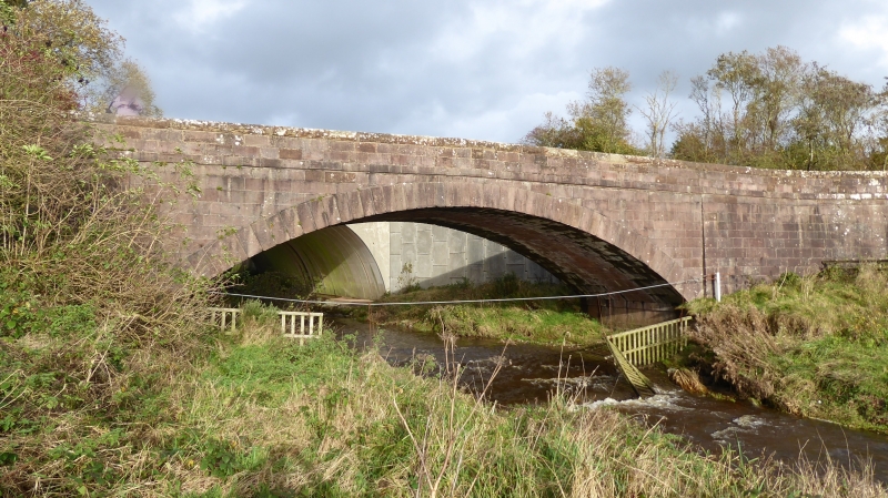
Thomas Telford, 1826 (inscription). Roadbridge; single
shallow segmental arch over Mein Water. Stugged pinkish
ashlar with channelled and graded voussoirs, band course
below parapet, latter gently ramped and splayed at approaches
over slightly battered abutments and with bull-faced coping.
Stone on E parapet inscribed "Park's Masons Thomas Telford
Esq. Engineer. 1826".
Near Ecclefechan Village.
External links are from the relevant listing authority and, where applicable, Wikidata. Wikidata IDs may be related buildings as well as this specific building. If you want to add or update a link, you will need to do so by editing the Wikidata entry.


Other nearby listed buildings
