Approximate Location Map
Large Map »
Latitude: 57.1467 / 57°8'48"N
Longitude: -2.0922 / 2°5'31"W
OS Eastings: 394518
OS Northings: 806207
OS Grid: NJ945062
Mapcode National: GBR SD8.XK
Mapcode Global: WH9QQ.TMWM
Plus Code: 9C9V4WW5+M4
Entry Name: 48 Marischal Street, Aberdeen
Listing Name: 48 Marischal Street
Listing Date: 12 January 1967
Category: B
Source: Historic Scotland
Source ID: 355265
Historic Scotland Designation Reference: LB20441
Building Class: Cultural
ID on this website: 200355265
Location: Aberdeen
County: Aberdeen
Town: Aberdeen
Electoral Ward: George St/Harbour
Traditional County: Aberdeenshire
Tagged with: Townhouse
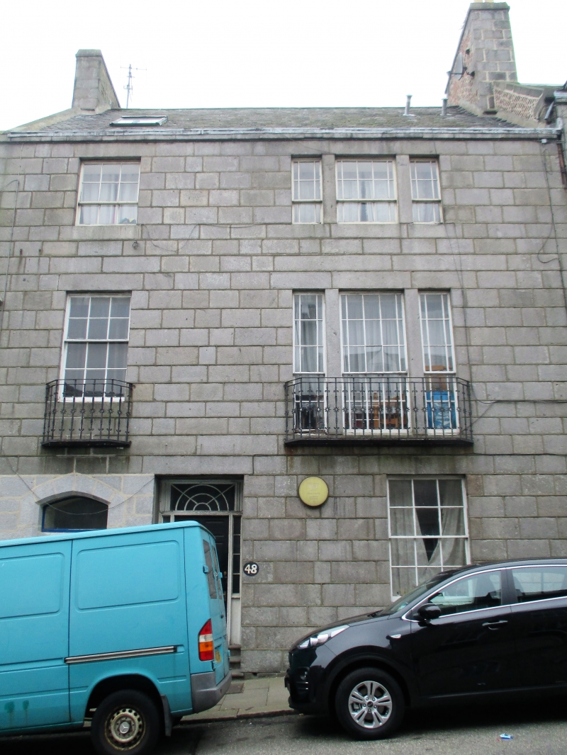
Circa 1789-1821. 3-storey, 2-bay townhouse situated on sloping site incorporating secondary entrance to the Elim Pentecostal Church (see separate listing) at ground floor left. Grey granite ashlar; eaves band. Recessed doorway with 6-panel timber door, narrow glazed sidelights and astragalled cast-iron fanlight above. Segmental-arched entrance to left (belonging to adjacent Elim Pentecostal Church). Tripartite openings with stone mullions to right bay 1st and 2nd floors. Decorative cast-iron balconies at 1st floor windows. 5-storey to rear (W) elevation with irregular fenestration.
Multi-pane timber sash and case windows with glazed margins at 1st and 2nd floor tripartites. Grey slate. Red brick stack to left gable with granite ashlar facing. Ashlar skew. Clay cans. Recessed cast-iron rainwater goods.
The Classical styling of No 48 forms a significant part of Marischal Street's lengthy run, contributing to its refined character. It's tripartite windows are a rare type in this part of Aberdeen. No 48 was built between 1789 (Alexander Milne's map of that year shows earlier buildings on Virginia Street below) and 1821 where it can be seen on John Wood's map of that year. The eminent local artist, William Dyce, lived at the address in the early 19th century.
Marischal Street (designed by William Law, 1767) is of great historic interest in terms of the early development of Classical Aberdeen. Formed on the site of the Earl Marischal's lodging and linking Castlegate with the Harbour below, Marischal Street is carried on embankments down a partly vaulted incline. It is the earliest example of this type of construction in Aberdeen, anticipating the larger scale development of Union Street and Edinburgh's South Bridge by 20 years. Originally having a fine granite bridge half way down, this was demolished and replaced in 1983 along with adjacent Nos 36-40 and 37-39 to allow the widening of Virginia Street below.
The buildings occupying the Southern half of the street are attributed to William Smith (d.1812), father of John Smith (the renowned Aberdeen architect - b.1781) and are generally grander and more varied. The street as a whole retains much of its original character despite the gradual move from domestic to commercial ownership throughout 19th century. It is thought to be the first street in Aberdeen paved with square granite sets.
Part of A Group with 3-60 (Inclusive Nos) Marischal Street.
External links are from the relevant listing authority and, where applicable, Wikidata. Wikidata IDs may be related buildings as well as this specific building. If you want to add or update a link, you will need to do so by editing the Wikidata entry.


Other nearby listed buildings
