Latitude: 55.9344 / 55°56'3"N
Longitude: -3.2061 / 3°12'21"W
OS Eastings: 324751
OS Northings: 671920
OS Grid: NT247719
Mapcode National: GBR 8LN.25
Mapcode Global: WH6SS.Q3HF
Plus Code: 9C7RWQMV+QH
Entry Name: John Livingstone's Tomb, 1 Chamberlain Road, Edinburgh
Listing Name: Chamberlain Road, Tomb of John Livingstone
Listing Date: 20 February 1985
Category: C
Source: Historic Scotland
Source ID: 363874
Historic Scotland Designation Reference: LB26960
Building Class: Cultural
ID on this website: 200363874
Location: Edinburgh
County: Edinburgh
Town: Edinburgh
Electoral Ward: Morningside
Traditional County: Midlothian
Tagged with: Tomb
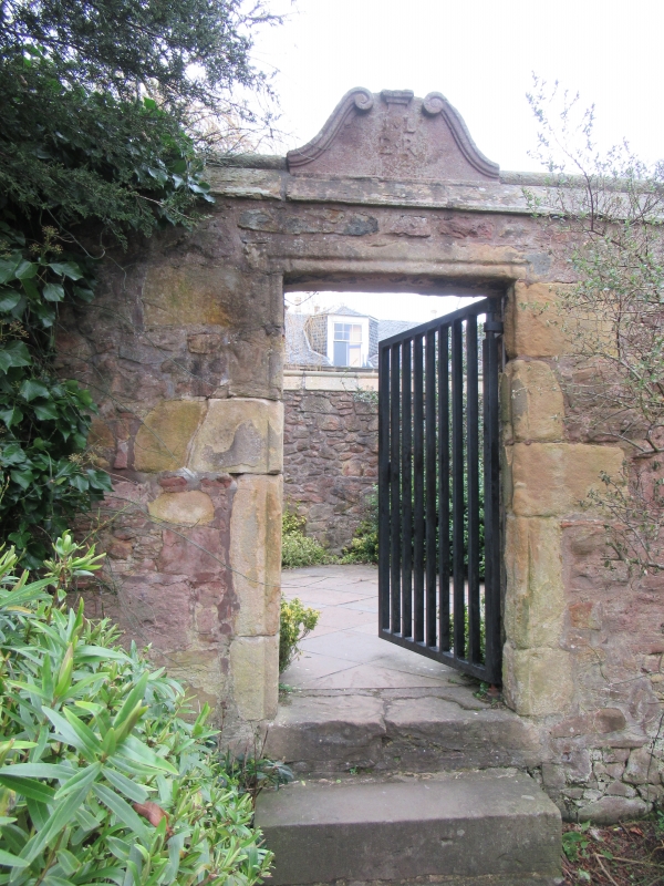
1645 (see Notes) memorial stone set into late 19th century walled enclosure incorporating 17th century fabric (see Notes). Roughly square-plan enclosure with roll-moulded coping and entrance to S elevation. Predominantly pink Hailes sandstone rubble with cream ashlar dressings. 3 steps to central 17th century roll-moulded doorway surmounted by 17th century scrolled open pediment inscribed with initials I.L and E.R to outer elevation and IL flanking heraldic shield charged with 3 cinquefoil flowers to inner elevation.
MEMORIAL STONE: 17th century. Roughly 6ft x 3ft. Set into interior of W wall, inscribed with at top 'MORS PATET HORA LATET' in arched scroll above winged hour glass over skull and cross bones; heraldic shield charged with 3 cinquefoil flowers and flanked by initials IL; inscription below as follows:
THIS SAINT WHOS CORPS LYES BU/RIED HEIR
LET ALL POSTERITIE ADMEIR
FOR VPRIGHT LIF IN GODLY FEIR
WHEN JUDGEMENTS DID THIS LAND / SURROUND
HE WITH GOD WAS WALKING FOUND
FOR WHICH OF MIDST OF FERS / HE'S CROUND
HEIR TO BE INTERRED BOTH HE
AND FRIENDS BY PROVIDENC AGRIE
NO AGE SHAL LOS HIS MEMORIE
HIS AGE 53 DIED / 1645
This small rectangular burial enclosure incorporates stonework from the original 17th century enclosure on the same site (see below for details) and contains a fine and very well preserved 17th century memorial tablet or gravestone, generally believed to commemorate John Livingstone (but see below). The date of the stone, 1645, suggests that it commemorates a victim of the virulent plague epidemic that swept through Edinburgh that year. If this is the case it has additional historic interest as one of a very small number of memorials (if not the only one) to survive from the time when plague victims had to be buried outwith the Edinburgh City Boundary. The enclosure is set back from the road at the rear of a small public garden beside 1 Chamberlain Road.
John Livingstone is variously described in records as a Merchant Burgess or Apothecary and purchased the lands of Greenhill House in 1636. He married Elizabeth Rigg in 1626 and is believed to have died in 1656. It is therefore improbable that the memorial stone relates to him, although the initials and shield, which is identical to that on the pediment (the initials on which presumably are those of John Livingstone and Elizabeth Rigg), indicates that the stone may have been for someone connected with the family.
The enclosure stood within the grounds of Greenhill House, close to its SE boundary. Greenhill House and its grounds were located on the Borough Muir, the area to which Edinburgh plague victims were expelled for isolation and burial. Even if the person buried here was not a plague victim it would have probably been impossible to take the corpse across the infected area for burial in a regular Edinburgh graveyard.
The burial enclosure is shown on Kirkwood's map of 1817, the earliest readily accessible map that shows this area at a sufficient scale to mark the tomb. Kirkwood's map and Lancefield's map of 1851 show the rectangular enclosure originally had a roof across its southern half. The well-preserved state of the stone is probably due to the fact that it was originally under cover. The 1st and 2nd edition OS maps show the enclosure without a roof. When the land of Greenhill house was developed, the enclosure became part of the garden ground of 1 Chamberlain Road. A disposition of 1894 relating to the sale of the house stipulates that the new owner must 'build up the walls around the said tomb' which were taken down by the deceased Dr Archibald Graham sometime proprietor''. It would therefore seem that by this date the enclosure had fallen into a considerable state of disrepair. The 3rd Edition OS map (surveyed 1894 and published 1895) shows the enclosure with a new set of steps to the S elevation, where the present entrance is located (earlier maps show the entrance on the W wall). From this and evidence of existing stonework it seems that the walls of the enclosure were largely rebuilt at the end of 1894, reusing decorative elements from the previous enclosure including the roll-moulded door surround and scrolled pediment. The roll-moulded coping appears to be late 19th century in date.
It has been suggested that the walls were completely taken down prior to the disposition on the deeds, from which it could be deduced that the original memorial stone was been lost and that the existing stone is a 19th century reproduction. However, the uneven spacing of the inscription across the stone is characteristic of a 17th century stonemason's hand. 17th century authenticity is also supported by the continuous appearance of the enclosure on all the 19th century OS maps (indicating that it was only partially dismantled before being rebuilt).
James Grant in Old and New Edinburgh confuses this gravestone with another that was originally situated near Bruntsfield House, roughly at the southern end of Spottiswoode Street. When the tenements in that area were erected the gravestone was moved and built into the boundary wall of Bruntsfield House. It is described in that position in the Old Edinburgh Club 1910 year book and the RCAHMS inventory (no 186). A number of ancillary buildings to Bruntsfield House, including the boundary wall, were demolished when James Gillespie's School was built in the early 1960s and the whereabouts of the Bruntsfield stone is no longer known.
External links are from the relevant listing authority and, where applicable, Wikidata. Wikidata IDs may be related buildings as well as this specific building. If you want to add or update a link, you will need to do so by editing the Wikidata entry.


Other nearby listed buildings