Approximate Location Map
Large Map »
Latitude: 55.9506 / 55°57'2"N
Longitude: -3.1832 / 3°10'59"W
OS Eastings: 326211
OS Northings: 673697
OS Grid: NT262736
Mapcode National: GBR 8QG.QC
Mapcode Global: WH6SM.2PGK
Plus Code: 9C7RXR28+6P
Entry Name: 246, 248 Canongate, Edinburgh
Listing Name: 246-248 (Even Nos) Canongate
Listing Date: 14 December 1970
Category: B
Source: Historic Scotland
Source ID: 366362
Historic Scotland Designation Reference: LB28455
Building Class: Cultural
Also known as: Edinburgh, 246, 248 Canongate
ID on this website: 200366362
Location: Edinburgh
County: Edinburgh
Town: Edinburgh
Electoral Ward: City Centre
Traditional County: Midlothian
Tagged with: Architectural structure
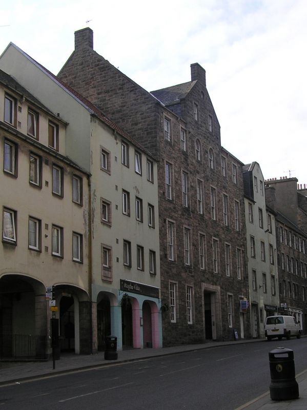
Circa 1750. (Restored, 1955, Robert Hurd, see Notes) 4-storey and attic, 3-bay tenement with 2-light wallhead gable to centre and shop to ground. Harled rubble with ashlar dressings. Squared pend leading to Pirrie's Close at ground floor left. Later shop front with fixed plate-glass window to right. Rebuilt to rear with octagonal stair outshot to left bay.
Predominantly 12-pane timber sash and case windows with horns. Grey slate. Ashlar skews. Cast-iron rainwater goods.
Nos 246-248 is a good example of a reconstructed 18th century Edinburgh tenement. The city has a particularly rich heritage of tenement construction and this building, which incorporates its mid 18th century street elevation including the former 2, 4 Pirrie's Close, is an important part of this heritage. The building was lowered by one storey as part of the restoration of 1955, when the distinctive wallhead gable was added. The rebuilt 1955 section to the rear is incorporated into the design of the adjacent Nos 242-244 Canongate (see separate listing), rebuilt in its entirety at the same time by Robert Hurd and Partners (see below).
The historic and architectural value of Edinburgh's Canongate area as a whole cannot be overstated. Embodying a spirit of permanence while constantly evolving, its buildings reflect nearly 1000 years of political, religious and civic development in Scotland. The Canons of Holyrood Abbey were given leave by King David I to found the burgh of Canongate in 1140. Either side of the street (a volcanic ridge) was divided into long, narrow strips of land or 'tofts'. By the end of the 15th century all the tofts were occupied, some subdivided into 'forelands' and 'backlands' under different ownership. Fuedal superiority over Canongate ceased after 1560. The following century was a period of wide-scale rebuilding and it was during this time that most of the areas' mansions and fine townhouses were constructed, usually towards the back of the tofts, away from the squalor of the main street. The 17th century also saw the amalgamation of the narrow plots and their redevelopment as courtyards surrounded by tenements. The burgh was formally incorporated into the City in 1856. Throughout the 19th Century the Canongate's prosperity declined as large sections of the nobility and middle classes moved out of the area in favour of the grandeur and improved facilities of Edinburgh's New Town, a short distance to the North. The Improvement Act of 1867 made efforts to address this, responding early on with large-scale slum clearance and redevelopment of entire street frontages. A further Improvement Act (1893) was in part a reaction to this 'maximum intervention', responding with a programme of relatively small-scale changes within the existing street pattern. This latter approach was more consistent with Patrick Geddes' concept of 'conservative surgery'. Geddes was a renowned intellectual who lived in the Old Town and was a pioneer of the modern conservation movement in Scotland which gathered momentum throughout the 20th century. Extensive rebuilding and infilling of sections of the Canongate's many tenements took place, most notably by city architects, E J McRae and Robert Hurd (mid 20th century) with some early frontages retained and others rebuilt in replica.
List description updated at resurvey (2007/08).
External links are from the relevant listing authority and, where applicable, Wikidata. Wikidata IDs may be related buildings as well as this specific building. If you want to add or update a link, you will need to do so by editing the Wikidata entry.


Other nearby listed buildings
