Latitude: 55.952 / 55°57'7"N
Longitude: -3.2168 / 3°13'0"W
OS Eastings: 324117
OS Northings: 673890
OS Grid: NT241738
Mapcode National: GBR 8HF.XV
Mapcode Global: WH6SL.KNFG
Plus Code: 9C7RXQ2M+R7
Entry Name: 12 Hawthornbank Lane, Dean Village, Edinburgh
Listing Name: 12 Hawthornbank Lane
Listing Date: 14 December 1970
Category: C
Source: Historic Scotland
Source ID: 368128
Historic Scotland Designation Reference: LB29019
Building Class: Cultural
ID on this website: 200368128
Location: Edinburgh
County: Edinburgh
Town: Edinburgh
Electoral Ward: Inverleith
Traditional County: Midlothian
Tagged with: Architectural structure
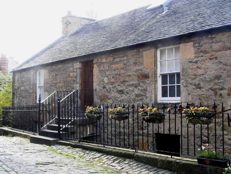
Early 19th century, 3-storey over substructure, 5-bay rectangular plan traditional house on steep riverbank falling to N. Coursed random rubble with some dressed margins.
S (HAWTHORNBANK LANE) ELEVATION: off-centre entrance platt oversailing lower ground leading to top floor; 2 windows to right. Door to right (E) at lower ground (middle floor), window to far right.
E (SIDE) ELEVATION: small window at top floor to far right.
N (WATER OF LEITH) ELEVATION: 3 stories, 5 evenly spaced windows at each floor, all over rubble substructure.
W (SIDE) ELEVATION: 2 windows to outer bays at top and middle floors; 1 window to left at lower floor.
Predominantly 12-pane in timber sash and case windows. Pitched roof with lead ridge; grey slates. Corniced rubble gable end stacks; no cans. Later railings edging basement to street on ashlar copes. Cast-iron rainwater goods.
12 Hawthornbank Lane is good example of an early 19th century traditional building with much of its original form retained to the exterior. The elevation to the river provides a good visual termination to views along the Water of Leith from both bridges in the Dean Village. The building uses the steeply sloping site well with the two basement storeys to the river elevation built into the river bank. The elevation to Hawthornbank Lane (S) has good streetscape value with the original cobbles still retained in the lane.
(Category changed from B to C(S) and list description revised 2009 as part of re-survey.)
External links are from the relevant listing authority and, where applicable, Wikidata. Wikidata IDs may be related buildings as well as this specific building. If you want to add or update a link, you will need to do so by editing the Wikidata entry.


Other nearby listed buildings