Approximate Location Map
Large Map »
Latitude: 55.9354 / 55°56'7"N
Longitude: -3.1901 / 3°11'24"W
OS Eastings: 325747
OS Northings: 672008
OS Grid: NT257720
Mapcode National: GBR 8PM.9T
Mapcode Global: WH6SS.Z21P
Plus Code: 9C7RWRP5+5W
Entry Name: 60 Grange Road, Edinburgh
Listing Name: 60 Grange Road, Superintendent's Lodge to Grange Cemetery
Listing Date: 14 December 1970
Category: B
Source: Historic Scotland
Source ID: 371287
Historic Scotland Designation Reference: LB30395
Building Class: Cultural
Also known as: Edinburgh, 60 Grange Road
ID on this website: 200371287
Location: Edinburgh
County: Edinburgh
Town: Edinburgh
Electoral Ward: Southside/Newington
Traditional County: Midlothian
Tagged with: Cemetery
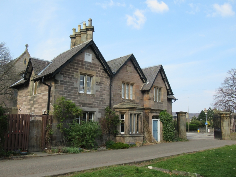
David Bryce 1847. Additions by J G Adams, 1890. 2-storey, 3-bay rectangular-plan asymmetrical lodge, made 4-bay by extension to W (1890). Stugged ashlar with polished ashlar dressings; architraved and chamfered reveals; ashlar mullions. Base course; overhanging timber eaves.
S (ENTRANCE) EKLEVATION: 4 gabled bays; advanced entrance bay to centre of original lodge with cavetto-corbelled 1st floor basket-arched chamfered doorway with modern door; bipartite timber mullioned windows on returns; tripartie window at 1st floor; tripartite windows flanking to outer right at ground, and breaking eaves in gabled dormerhead at 1st floor; single storey corniced and slab canopied, 5-light canted window to advanced bay to left of door; tripartite window above; square blank tablet set in gablehead; tripartite window at ground floor to outer left; bipartite window above; square blank painted tablet set in gablehead.
E ELEVATION: full-height canted window swept to gablehead; cill coruse, string course dividing storeys beneath panelled apron, and band course above 1st floor windows; square blkank tablet set in gablehead.
W ELEVATION: bipartite window breaking eaves in gabled dormerhead.
N (GRANGE ROAD) ELEVATION: gabled bay at centre; irregular single and bipartite fenestration; secondary entrance with modern door; square blank tablet set in gablehead.
3-pane windows with central casement panels. Variegated fish-scale slate roof; lead flashing; tall paired diamond wallhead (original end wall) stacks to N, with double cornices, group of 4 to W; moulded cans; some original rainwater goods.
INTERIOR: not seen 1990.
See Grange Cemetery, listed separately.
External links are from the relevant listing authority and, where applicable, Wikidata. Wikidata IDs may be related buildings as well as this specific building. If you want to add or update a link, you will need to do so by editing the Wikidata entry.


Other nearby listed buildings
