Approximate Location Map
Large Map »
Latitude: 55.8637 / 55°51'49"N
Longitude: -4.2541 / 4°15'14"W
OS Eastings: 259029
OS Northings: 665692
OS Grid: NS590656
Mapcode National: GBR 0LK.QR
Mapcode Global: WH3P2.MWF5
Plus Code: 9C7QVP7W+F9
Entry Name: 130, 132, 134 West Nile Street, Glasgow
Listing Name: 130-134 (Even Nos) West Nile Street
Listing Date: 21 July 1988
Category: C
Source: Historic Scotland
Source ID: 376858
Historic Scotland Designation Reference: LB33256
Building Class: Cultural
ID on this website: 200376858
Location: Glasgow
County: Glasgow
Town: Glasgow
Electoral Ward: Anderston/City/Yorkhill
Traditional County: Lanarkshire
Tagged with: Bank building
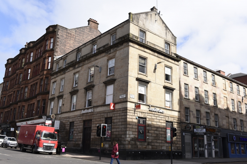
Circa 1835. 3-storey and attic corner tenement block with
modern shops at ground floor, 5 x 2 unequal bays. West Nile
Street elevation 3 main bays breaking forward at S. Painted
ashlar, rusticated at ground floor; ground floor band course.
All windows sash and case in architraves latter dropped at
2nd floor. 1st floor moulded cill band, windows corniced;
consoled in 2nd bay from S in West Nile Street. 2nd floor
plain frieze and cornice. Attic storey with windows breaking
through blocking course. Attic band. Skewed gable with stack
to Bath Street.
External links are from the relevant listing authority and, where applicable, Wikidata. Wikidata IDs may be related buildings as well as this specific building. If you want to add or update a link, you will need to do so by editing the Wikidata entry.


Other nearby listed buildings
