Approximate Location Map
Large Map »
Latitude: 56.1208 / 56°7'14"N
Longitude: -3.9436 / 3°56'37"W
OS Eastings: 279261
OS Northings: 693704
OS Grid: NS792937
Mapcode National: GBR 1C.L80Z
Mapcode Global: WH4P6.DF93
Plus Code: 9C8R43C4+8G
Entry Name: 38-40 St John Street, Stirling
Listing Name: 41 Broad Street, Church Wynd and 38 and 40 St John Street
Listing Date: 4 November 1965
Category: C
Source: Historic Scotland
Source ID: 387400
Historic Scotland Designation Reference: LB41244
Building Class: Cultural
ID on this website: 200387400
Location: Stirling
County: Stirling
Town: Stirling
Electoral Ward: Stirling North
Traditional County: Stirlingshire
Tagged with: Tenement
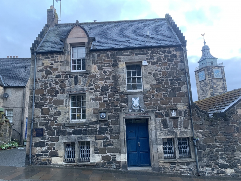
Sir Frank Mears, 1937, reworking of earlier tenement reviving, 17th century, Scottish style tenement. 3-storey block on Broad Street linked to 2-storey block on St John Street. Rubble with ashlar margins.
N (BAKER STREET) ELEVATION: bays to right: roll-moulded surround to entrance at lower ground to left, carved ogival panel above (see Notes), bay to right window in raised ground floor, stone mullioned tripartite window to outer right, in crow step gabled bay further tripartites to 1st and 2nd floor and small window in gablehead.
Bays to left: 3 windows to each floor.
W (CHURCH WYND) ELEVATION: 5 bays, inner bay to right windows smaller. Crowstepped gable with stack to 2 bays at centre and left of centre, blank bay to outer left, adjoining wall to outer right with gate entrance linking with building on St John Street.
Timber sash and case windows with 15-pane glazing, 12-pane at top floor in bays to left, N gable and S gable. Grey slates, gablehead stacks.
W (CHURCH WYND) ELEVATION: 4 bays at ground, grouped 3-1, windows at ground with gablet dormerheads above, dormer to right with stone finial. Crowstepped gables.
S (ST JOHN STREET) ELEVATION: 2 windowed bays at ground, regular fenestration above, crowstepped gables.
Timber sash and case with 12-pane glazing. Steeply pitched roofs, grey slates, stacks in N gable and in roof to right with cans.
INTERIOR: not seen 1997
Carved ogival panel rescued from the now demolished Lawries turnpike in Baker Street. Part of a wider municipal development in the Scottish domestic revival idiom during these years in Baker, Bow, Broad and St John Streets.
External links are from the relevant listing authority and, where applicable, Wikidata. Wikidata IDs may be related buildings as well as this specific building. If you want to add or update a link, you will need to do so by editing the Wikidata entry.


Other nearby listed buildings
