Approximate Location Map
Large Map »
Latitude: 55.5489 / 55°32'56"N
Longitude: -2.841 / 2°50'27"W
OS Eastings: 347036
OS Northings: 628679
OS Grid: NT470286
Mapcode National: GBR 84L8.QP
Mapcode Global: WH7WV.BSDH
Plus Code: 9C7VG5X5+HJ
Entry Name: The Old Manse, Hallidays Park, Selkirk
Listing Name: Hallidays Park, Old Manse with Boundary Walls
Listing Date: 11 December 1996
Category: C
Source: Historic Scotland
Source ID: 390359
Historic Scotland Designation Reference: LB43755
Building Class: Cultural
ID on this website: 200390359
Location: Selkirk
County: Scottish Borders
Town: Selkirk
Electoral Ward: Selkirkshire
Traditional County: Selkirkshire
Tagged with: Manse
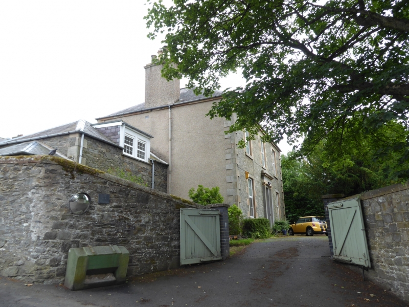
Mid 19th century with later alterations and additions. 2-storey, 3-bay classical, rectangular-plan house with lower 2-storey addition to NE and modern conservatory to SW. Squared whinstone with droved red sandstone dressings to NW; whinstone rubble with droved red sandstone dressings to SE; harled SW and NE elevations. Base course, raised quoins, tails to margins, eaves course.
NW ELEVATION: 2 ashlar steps to deep-set panelled door to centre, border-glazed rectangular fanlight, set in partly cement-rendered pilastered and corniced doorpiece; window at 1st floor above. Window to each floor of flanking bays. Whinstone rubble addition set back to left with bipartite dormer to right of centre.
SE ELEVATION: asymmetrical. Stair window to centre. Window to each floor of flanking bays. Small window at 1st floor between centre and bay to right. 3-bay addition with door to ground of outer bays. Window to left of centre at ground and gabled window breaking eaves to centre at 1st floor.
SW ELEVATION: window at ground of bay to left. Door to outer right with modern conservatory projecting.
Modern glazing. Platform and piended slate roof with flat-roofed dormer to outer bays, SE elevation. Wallhead coped stacks to side elevations.
INTERIOR: not seen, 1995.
BOUNDARY WALLS: whinstone rubble wall with rounded ashlar coping.
External links are from the relevant listing authority and, where applicable, Wikidata. Wikidata IDs may be related buildings as well as this specific building. If you want to add or update a link, you will need to do so by editing the Wikidata entry.


Other nearby listed buildings
