Approximate Location Map
Large Map »
Latitude: 60.7887 / 60°47'19"N
Longitude: -0.829 / 0°49'44"W
OS Eastings: 463853
OS Northings: 1212317
OS Grid: HP638123
Mapcode National: GBR S097.2QH
Mapcode Global: XHF75.M3Z2
Plus Code: 9CGXQ5QC+F9
Entry Name: The Hamars, Haroldswick, Beach Road, Unst
Listing Name: Haroldswick, the Hamars, Including Steading, and Garden and Boundary Walls
Listing Date: 30 March 1998
Category: B
Source: Historic Scotland
Source ID: 392146
Historic Scotland Designation Reference: LB45293
Building Class: Cultural
Also known as: Unst, Beach Road, Haroldswick, The Hamars
ID on this website: 200392146
Location: Unst
County: Shetland Islands
Electoral Ward: North Isles
Parish: Unst
Traditional County: Shetland
Tagged with: Farmstead
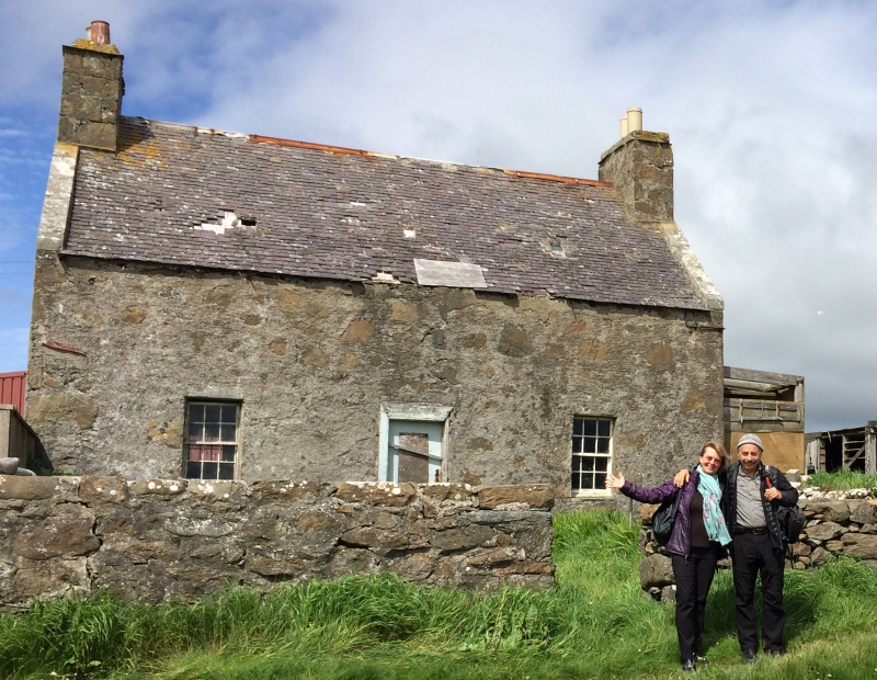
Late 18th century with mid 19th century wing. Single storey and attic 3-bay traditional symmetrical farmhouse with 2-storey wing to rear forming L-plan. Harled rubble walls.
SE (PRINCIPAL) ELEVATION: modern door to centre flanked by regularly-fenestrated bays; high wallhead with concealed attic.
NE ELEVATION: gable of principal range to left; ground floor concealed by modern lean-to addition, window to left at 1st floor; rear wing slightly recessed to right with small square window centred at 1st floor.
NW (REAR) ELEVATION: single window at ground to right; rear wing advanced to left of centre comprising small window to right at 1st floor in NW-facing gable, windows at ground and 1st floors in SE elevation with later rendered lean-to porch in re-entrant angle.
SW GABLE: window to right at attic; rear wing recessed at left.
Timber sash and case windows; 12-pane to principal range, 4-pane to rear wing. Purple-grey slate roof with small skylights to principal range, stone slabs to rear wing. Harl-pointed rubble gablehead stacks, coped, with circular cans. Ashlar skew copes to principal range, cement-rendered to rear wing.
STEADING: random rubble L-plan steading comprising gabled single storey and loft range with stone slab roof aligning NE side of house with piend-roofed single storey range adjoining at right angles to N. Vertically-boarded timber door centred in NW gable, and to outer right of NW elevation of former and latter ranges respectively.
GARDEN AND BOUNDARY WALLS: random rubble wall enclosing garden to principal elevation, continued as harl-pointed rubble wall along road to SE of steading. Additional walls linking NE gable of house to steading and extending to NW.
A remarkably intact example of a small Shetland farm with early origins. Domestic architecture built before the end of the 19th century is now rarely found in this little-altered state. The house displays well the character of much of Shetland's building stock prior to later 20th century alterations, and forms a picturesque sea-front focus to Haroldswick.
External links are from the relevant listing authority and, where applicable, Wikidata. Wikidata IDs may be related buildings as well as this specific building. If you want to add or update a link, you will need to do so by editing the Wikidata entry.


Other nearby listed buildings
