Approximate Location Map
Large Map »
Latitude: 56.12 / 56°7'11"N
Longitude: -3.453 / 3°27'10"W
OS Eastings: 309757
OS Northings: 692867
OS Grid: NT097928
Mapcode National: GBR 1Y.LJ6Q
Mapcode Global: WH5QK.XFWP
Plus Code: 9C8R4G9W+XQ
Entry Name: Stables, Bowleys
Listing Name: Bowleys
Listing Date: 23 March 2001
Category: C
Source: Historic Scotland
Source ID: 395137
Historic Scotland Designation Reference: LB47800
Building Class: Cultural
ID on this website: 200395137
Location: Dunfermline
County: Fife
Electoral Ward: West Fife and Coastal Villages
Parish: Dunfermline
Traditional County: Fife
Tagged with: Stable
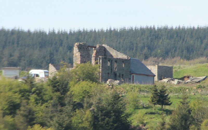
Late 18th-early 19th century. 2-storey, 3-bay, roofless, lean-to structure. Exposed tooled rubble stone; ashlar surrounds to openings.
E (PRINCIPAL) ELEVATION: symmetrical elevation; central door; remains of former forestair; advanced stone to top left of door and raggles of steps to right. Single ground floor windows flank door. Central 1st floor door and flanking windows hug eaves. 2 stones project eastwards from NE quoin.
S ELEVATION: remains of later building to left; central opening at 1st floor. Remains of wall extend southwards from E quoin and W quoin of later building, enclosing small area of ground.
W ELEVATION: beam recesses at 1st and 2nd floors for former attached building; harled 1st floor. Remains of later building gable wall extends from centre of elevation.
N ELEVATION: remains of wall extend northwards from N gable wall.
INTERIOR: derelict interior. Remains of flues of former fireplaces in each gable wall. 7 round-headed recesses in rear wall begin at ground level of former 1st floor, falling to ground floor; ashlar surrounds at 1st floor only.
No doors or windows remain. Some flat-head gable coping stones survive.
The purpose and date of the building are uncertain. It is depicted as 'The Old Stables' on the 1st Edition OS Map and is thought to have housed the horses working on the whinstone quarry to the N. The round-headed recesses may be the top of hay hecks for feeding the horses. It has been suggested that it was a laird's house, possibly belonging to the Dunnygask Estate, which was converted into stables at the end of the 18th century. The building is currently redundant in use and in a ruinous state.
External links are from the relevant listing authority and, where applicable, Wikidata. Wikidata IDs may be related buildings as well as this specific building. If you want to add or update a link, you will need to do so by editing the Wikidata entry.


Other nearby listed buildings
