Approximate Location Map
Large Map »
Latitude: 57.2292 / 57°13'45"N
Longitude: -5.6556 / 5°39'20"W
OS Eastings: 179448
OS Northings: 821305
OS Grid: NG794213
Mapcode National: GBR D9FM.07F
Mapcode Global: WH0BF.3K3D
Plus Code: 9C9P68HV+MP
Entry Name: Glenelg Slipway (Kylerhea Ferry)
Listing Name: Glenelg Slipway (Kylerhea Ferry)
Listing Date: 30 March 2009
Category: B
Source: Historic Scotland
Source ID: 400187
Historic Scotland Designation Reference: LB51306
Building Class: Cultural
ID on this website: 200400187
Location: Glenelg
County: Highland
Electoral Ward: Eilean á Chèo
Parish: Glenelg
Traditional County: Inverness-shire
Tagged with: Slipway
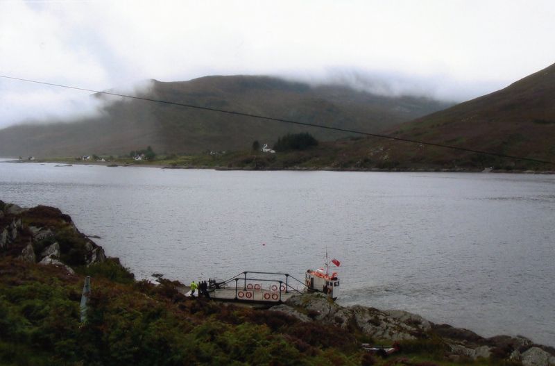
Thomas Telford, 1818-1821. Dressed whinstone slipway incorporating rare cattle droving ramp, located at shortest crossing point between the mainland and Isle of Skye, serving the Kylerhea Ferry. Counterpart slipway located on opposite bank of the Kyle Rhea in Strath Parish (see separate listing).
Large dressed whinstone blocks laid in courses, shelving into water. Paved with stone setts, currently covered with concrete screed (2009).
Cattle ramp: 90ft by 20ft, orientated at right angle to slipway and laid with roughly coursed cobbles; natural rock embankment to E side; 120ft rubble bulwark to W, curving at angle adjoining slipway.
Part of a 'B Group' comprising 'Kylerhea Slipway (Kylerhea Ferry)', the 'Kylerhea Ferry, Old Ferry Inn' situated to the N of the Glenelg slipway and the 'Kylerhea Old Inn' situated to the S of the Kylerhea slipway (see separate listings).
Built by world-renowned engineer Thomas Telford and his associates, the Glenelg slipway, along with its counterpart slipway at Kylerhea (see separate listing) marks the shortest and most historically significant crossing-place between mainland Scotland and the Isle of Skye. This was the primary cattle droving route out of the islands. The Glenelg slipway includes a rare cattle droving slip understood to be the only one of its kind in Scotland. It is innovatively incorporated into the design by Telford and clearly evidences its earlier historic use. A passenger ferry service is also recorded as operating at this location in the 17th century. It was part of General Wade's military road system in the mid 18th century.
Cattle droving was critical to the economy of the western Highlands between the 16th and late 19th centuries. The cattle slip at Glenelg was engineered to help facilitate the movement of this livestock with as many as 8000 cattle swimming across the Kyle Rhea at this spot each year. In 1811, Thomas Telford noted that Kylerhea would always remain the usual ferry for the Black Cattle of Skye and later estimated that £6000 was saved each year by using the ferry crossing as a drove road as it was the quickest route south. 300 cattle could be taken across in a few hours, funnelled out of the water via the slipway before being driven long distances to market, notably at Crieff, Falkirk and Linlithgow. The arrival of sheep and the railway to the West Highlands in the later 19th century saw the demise of droving as a way of life.
The slipways also serve as termini of the mountainous approach roads which wind their way to and from the Kyle Rhea ferry. Originally built around 1750 under Major Caulfield's direction for General Wade, the road was subsequently developed in 1805 by the Highland Roads Commission, making use of substantial buttressed retaining walls, to act as the principle route into and across Skye.
The slipway forms part of a wider 'B' grouping including the counterpart 'Kylerhea Slipway', the former 'Kylerhea Old Inn' 200m to the south of the Kylerhea slipway, and the former 'Old Ferry Inn' located 200m to the N of Glenelg slipway (see separate listings). The two former Inns (circa 1800) are comparable in scale and massing, with the 'Kylerhea Old Inn' understood to have been built by eminent Scottish architect, James Gillespie Graham.
A lighthouse of 1910, relocated from nearby Sandaig in 2002 and now inactive, overlooks the Glenelg slipway. Its octagonal shaft and triagonal glazed lantern make a positive contribution to the setting of the slipway and the Old Ferry Inn. A swivel-decked ferry boat continues to run (2009) between the slipways from April to October, serving the local community and the tourist trade.
Previously listed at category C(S). List description updated January 2010.
External links are from the relevant listing authority and, where applicable, Wikidata. Wikidata IDs may be related buildings as well as this specific building. If you want to add or update a link, you will need to do so by editing the Wikidata entry.


Other nearby listed buildings
