Latitude: 55.8695 / 55°52'10"N
Longitude: -3.1686 / 3°10'6"W
OS Eastings: 326969
OS Northings: 664655
OS Grid: NT269646
Mapcode National: GBR 609K.TS
Mapcode Global: WH6T0.9QDQ
Plus Code: 9C7RVR9J+RH
Entry Name: Dryden Tower
Listing Name: University of Edinburgh, Dryden Tower, Langhill Farm, Roslin
Listing Date: 22 January 1971
Last Amended: 17 July 2015
Category: B
Source: Historic Scotland
Source ID: 405372
Historic Scotland Designation Reference: LB13032
Building Class: Cultural
ID on this website: 200405372
Location: Lasswade
County: Midlothian
Electoral Ward: Midlothian West
Parish: Lasswade
Traditional County: Midlothian
Tagged with: Tower
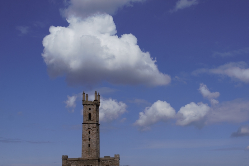
1ST STAGE: NE ELEVATION: 3-bay. Evenly disposed square-plan columns with cornice and square cap (one missing) between each bay. Single window (blinded) to each bay; ashlar cope to wall sections between.
SW ELEVATION: paired slit windows to advanced 1st stage of tower; flanking windows to base structure (one blinded).
2ND STAGE: 2 small square-headed windows with small round headed window above, within recessed round-headed arch to each face.
3RD STAGE: round-arched window with circular window above to each face.
INTERIOR: turnpike stair inside tower.
Initially intended as a hilltop eye-catcher for Dryden House, demolished in 1938, and is still a prominent landmark. It originally belonged to a wider landscape known locally as 'The Pleasure' which was destroyed by the construction of Bilston Glen colliery. It was perhaps built to commemorate the Battle of Roslin, 24th February, 1303, when the Scots successfully defeated three English Divisions.
The tower first appears on the 1854 Ordnance Survey map of Edinburghshire.
Repairs during 2014-15 saw the introduction of a stone gargoyle rainwater spout to upper eaves course of tower.
Listed building record and statutory address updated (2015). Previously listed as 'Dryden Tower'.
External links are from the relevant listing authority and, where applicable, Wikidata. Wikidata IDs may be related buildings as well as this specific building. If you want to add or update a link, you will need to do so by editing the Wikidata entry.


Other nearby listed buildings