History in Structure

Pack Horse Bridge

A Grade II* Listed Building in Hope, Flintshire

More Photos »
Approximate Location Map
Large Map »

Coordinates

Latitude: 53.1111 / 53°6'40"N

Longitude: -3.038 / 3°2'16"W

OS Eastings: 330613

OS Northings: 357610

OS Grid: SJ306576

Mapcode National: GBR 74.80JJ

Mapcode Global: WH88R.92K7

Plus Code: 9C5R4X66+FQ

Entry Name: Pack Horse Bridge

Listing Date: 2 July 1962

Last Amended: 6 May 1998

Grade: II*

Source: Cadw

Source ID: 30

Building Class: Transport

Also known as: Caergwrle Packhorse Bridge

ID on this website: 300000030

Location: Spanning the River Alyn in the centre of Caergwrle village, at the end of Fellows Lane.

County: Flintshire

Community: Hope (Yr Hob)

Community: Hope

Locality: Caergwrle

Built-Up Area: Hope

Traditional County: Flintshire

Tagged with: Bridge Packhorse bridge

Find accommodation in
Ffrith

History

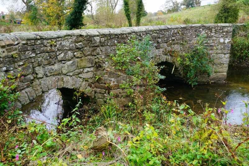
Vernacular packhorse bridge of probable medieval origin (given this river crossing's proximity to Caergwrle Castle), though extended and altered in the C17 and later.

Exterior

Narrow packhorse bridge approximately 50m long; of sandstone and freestone rubble with low parapets (C18 or C19 replacements) with curved sandstone capping stones. The bridge spans the river in two places with an irregular central island. There are four crude segmental arches in all with three sets of surviving triangular cutwaters, two retaining parapetted refuges. A plain late C19 gate on the upstream side gives access to the island; irregular masonry to the lower bridge walls in this section.

Reasons for Listing

Listed Grade II* as a fine and unusually long sub-medieval packhorse bridge with probable medieval origins.

Scheduled Ancient Monument FL133.

External Links

External links are from the relevant listing authority and, where applicable, Wikidata. Wikidata IDs may be related buildings as well as this specific building. If you want to add or update a link, you will need to do so by editing the Wikidata entry.

Recommended Books

Other nearby listed buildings

  • II Lilac Cottage
    Set back on a corner site adjacent to a narrow lane leading from Derby Road to the High Street, in the centre of Caergwrle village.
  • II Ty Gwyn, including attached wall and outbuildings
    Almost opposite Derby Arms PH.
  • II Bridge End Bridge
    Spanning the river Alyn and carrying the A 550 approximately 1km S of Hope and 0.5km W of Caergwrle villages.
  • I Caergwrle Castle
    Strikingly-sited on a high natural hilltop site in the centre of Caergwrle; accessed via a path leading from the main road.
  • II Castellated Gateway and Walls at Rhydyn Hall
    Located immediately W of the lane some 100m SE of Bridge End bridge; giving access to the lower approach to Rhydyn Hall and the former spa.
  • II* Plas-yn-Bwl
    Located at the southern edge of Caergwrle village on an elevated site above the A 541 (Wrexham Road); situated at the end of the lane partly behind low rubble forecourt walls.
  • II* Rhydyn Hall
    Overloking the the river Alyn to the E, on the line of Wat's Dyke, approximately 0.5km E of Caergwrle village centre; accessed via an unmetalled lane running S from the road.
  • II Sarn House
    Located on a narrow corner plot between Hawarden Road and Sarn Lane in the centre of the village.

BritishListedBuildings.co.uk is an independent online resource and is not associated with any government department. All government data published here is used under licence. Please do not contact BritishListedBuildings.co.uk for any queries related to any individual listed building, planning permission related to listed buildings or the listing process itself.

British Listed Buildings is a Good Stuff website.