History in Structure

Bridge over Former Railway Line at Llannerch Park

A Grade II Listed Building in Trefnant, Denbighshire

More Photos »
Approximate Location Map
Large Map »

Coordinates

Latitude: 53.2337 / 53°14'1"N

Longitude: -3.4281 / 3°25'41"W

OS Eastings: 304774

OS Northings: 371692

OS Grid: SJ047716

Mapcode National: GBR 6M.07RH

Mapcode Global: WH76N.9ZTC

Plus Code: 9C5R6HMC+FQ

Entry Name: Bridge over Former Railway Line at Llannerch Park

Listing Date: 2 April 1993

Last Amended: 9 January 1998

Grade: II

Source: Cadw

Source ID: 278

Building Class: Transport

ID on this website: 300000278

Location: To E of A525 approximately 1km N of Trefnant. Carries minor road over former Vale of Clwyd Railway cutting opposite gates of Llannerch Park.

County: Denbighshire

Town: Denbigh

Community: Trefnant

Community: Trefnant

Locality: Llannerch

Traditional County: Denbighshire

Tagged with: Road bridge

Find accommodation in
Tremeirchion

History

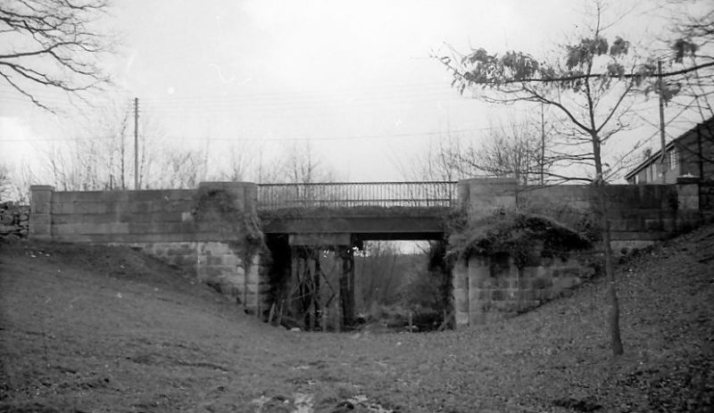
Dated 1858; part of the Vale of Clwyd Railway, constructed from 1857-1858 (opened October 1858).

Exterior

Cast iron and stone road bridge. Abutments to E and W in rock-faced squared masonry with smooth levelling course. Above abutments, stone parapet walls have large piers to inner ends, and smaller piers to outer ends; heavy flat copings to piers. Span of bridge in iron with brick soffits. Girders to N and S carry foundry plate 'Brymbo 1858'. Cast iron railings to N and S have tall round-headed arcade with pierced spandrels and hand-rails.

Reasons for Listing

Listed for its special interest as an original bridge from one of North Wales' earliest branch lines, and as an example of work from the famous Brymbo Foundry.

External Links

External links are from the relevant listing authority and, where applicable, Wikidata. Wikidata IDs may be related buildings as well as this specific building. If you want to add or update a link, you will need to do so by editing the Wikidata entry.

Recommended Books

Other nearby listed buildings

  • II Milestone
    On the roadside, set against a low rubble wall approximately 1km NW of Trefnant village.
  • II Milestone
    Located on the roadside, set back on the edge of a pavement, approximately 80m SE of the crossroads between the main road, Nant-y-Park Road and the B5381.
  • II The Clocktower
    Forming part of a former service range closing the western side of the main service courtyard, immediately to the W of Llannerch Hall.
  • II The Coach House
    Forming part of a service range closing the western side of the main service courtyard, immediately to the W of Llannerch Hall.
  • II The Old Barn
    Forming part of an L-shaped former service range, immediately to the W of Llannerch Hall.
  • II Middle Lodge
    Located at the NE boundary of the community, approximately 1.2km NE of Trefnant village; sited on the NE side of the unclassified road from Trefnant to Tremeirchion.
  • II Pont-yr-allt-Goch (partly in Cefnmeiriadog Community)
    Spanning the Afon Elwy at the western boundary of the community.
  • II* No 12 Llannerch Hall
    Set in its own mature parkland at the northern edge of the community, approximately 1km N of Trefnant village; accessed via a long drive running NE from the A 525 St. Asaph to Denbigh road.

BritishListedBuildings.co.uk is an independent online resource and is not associated with any government department. All government data published here is used under licence. Please do not contact BritishListedBuildings.co.uk for any queries related to any individual listed building, planning permission related to listed buildings or the listing process itself.

British Listed Buildings is a Good Stuff website.