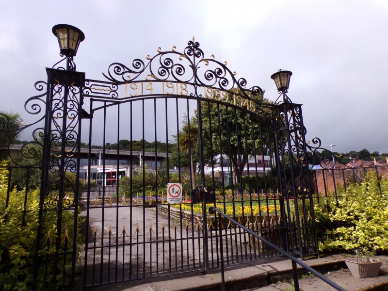
War Memorial Gates, Railings & Stone Piers
A Grade II Listed Building in Holywell, Flintshire
Coordinates
Latitude: 53.2727 / 53°16'21"N
Longitude: -3.222 / 3°13'19"W
OS Eastings: 318607
OS Northings: 375777
OS Grid: SJ186757
Mapcode National: GBR 5ZYL.7J
Mapcode Global: WH76K.GZYY
Plus Code: 9C5R7QFH+36
Entry Name: War Memorial Gates, Railings & Stone Piers
Listing Date: 19 August 1991
Grade: II
Source: Cadw
Source ID: 485
Building Class: Commemorative
ID on this website: 300000485
Location: Closing the top of Panton Place at the entrance to the Memorial Gardens; the piers adjoin the ends of the two brick terraces.
County: Flintshire
Community: Holywell (Treffynnon)
Community: Holywell
Built-Up Area: Holywell
Traditional County: Flintshire
Tagged with:
War memorial
History
Probably errected after the 2nd World War.
Exterior
Cast-iron gates and gate piers with openwork ornament; dated overthrow and octagonal lanterns over the piers. Quadrant shapped railings step down to end at the large square coursed rubble piers with memorial tablets facing the stone steps; plinth and cornice band; modern steps to base and modern central handrail.
Reasons for Listing
Included for group value with the important Panton Place NW and SE terraces.
External Links
External links are from the relevant listing authority and, where applicable, Wikidata.
Wikidata IDs may be related buildings as well as this specific building. If you want to add or update a link, you
will need to do so by editing the Wikidata entry.
Recommended Books
Other nearby listed buildings
-
II
16
Planned terrace leading off the SW side of the High Street; adjoins National Westminster Bank at NE end; Memorial Gardens to SW end. Set in the slope, facing Nos 1 to 13 (SE side).
-
II
13
Planned terrace leading off the SW side of the High Street; Memorial Gardens to SW end. Set in slope, facing Nos 14 to 29 (NW side).
-
II
14
Planned terrace leading off the SW side of the High Street; adjoins National Westminster Bank at NE end; Memorial Gardens to SW end. Set in the slope, facing Nos 1 to 13 (SE side).
-
II
11
Planned terrace leading off the SW side of the High Street; Memorial Gardens to SW end. Set in slope, facing Nos 14 to 29 (NW side).
-
II
12
Planned terrace leading off the SW side of the High Street; Memorial Gardens to SW end. Set in slope, facing Nos 14 to 29 (NW side)
-
II
17
Planned terrace leading off the SW side of the High Street; adjoins National Westminster Bank at NE end; Memorial Gardens to SW end. Set in the slope, facing Nos 1 to 13 (SE side).
-
II
15
Planned terrace leading off the SW side of the High Street; adjoins National Westminster Bank at NE end; Memorial Gardens to SW end. Set in the slope, facing Nos 1 to 13 (SE side).
-
II
10
Planned terrace leading off the SW side of the High Street; Memorial Gardens to SW end. Set in slope, facing Nos 14 to 29 (NW side).