Latitude: 53.1286 / 53°7'43"N
Longitude: -3.2788 / 3°16'43"W
OS Eastings: 314533
OS Northings: 359815
OS Grid: SJ145598
Mapcode National: GBR 6T.6VDD
Mapcode Global: WH779.LMWD
Plus Code: 9C5R4PHC+FF
Entry Name: Old Church of St Peter
Listing Date: 19 July 1966
Last Amended: 24 June 1999
Grade: II
Source: Cadw
Source ID: 738
Building Class: Religious, Ritual and Funerary
Also known as: Old St Peter's Church, Llanbedr Dyffryn Clwyd
Old St. Peter's Church
Old St. Peter's Church, Llanbedr Dyffryn Clwyd
ID on this website: 300000738
Location: Strikingly located within a raised and revetted churchyard on the eastern slope of the Vale of Clwyd, approximately 0.5km N of the village centre and 200m SW of Llanbedr hall; accessed via a footpath
County: Denbighshire
Town: Ruthin
Community: Llanbedr Dyffryn Clwyd
Community: Llanbedr Dyffryn Clwyd
Locality: Llanbedr Dyffryn-Clwyd
Traditional County: Denbighshire
Tagged with: Ruins Former church
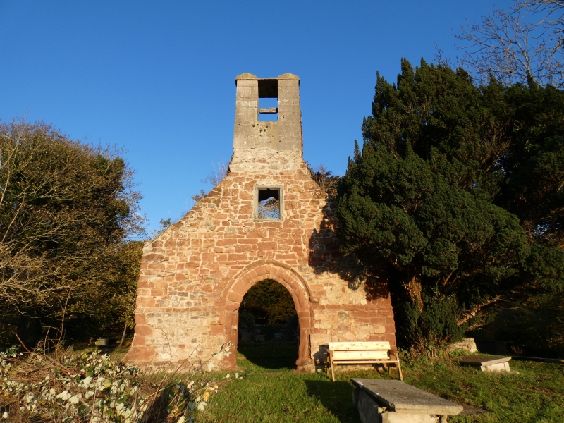
First mentioned in the Lincoln 'Taxatio' of 1291 and valued at £418 in the 'Valor' of 1535. The fabric is of two main periods; the western half is probably late C13, and the eastern half a rebuild or extension of the C14 or C15. With the exception of a post-Reformation 2-light mullioned window to the former bell loft and a first-half C19 bellcote, the surviving openings, such as they are, are medieval, and the W, S and (blocked) N entrances belong to the primary construction phase. The church was abandoned in 1863 in favour of a new parish church, built at the expense of Mr Jesse of Llanbedr Hall to designs by Poundley and Walker.
The church is currently a roofless ruin and with the exception of the W gable, which survives to full height, the walls have been reduced to a height of some 2m. A late medieval timber-framed S porch, recorded as still standing in 1966, has now gone; some of its rotten members are stacked in the NW corner.
Ruins of former parish church. Of single cell plan with walls reduced except at the W end where full height. The fabric is of two phases of construction, distinguished by clear masonry breaks to the N and S nave walls. The earlier, western half is mostly of red sandstone rubble construction; the eastern is mostly of limestone and slatestone rubble; there is evidence for the walls having formerly been externally rendered and limewashed. The masonry of the W gable has suffered much weather erosion. It has a high chamfered plinth and a pointed-arched central entrance with returned label. Above this is a 2-light bell-loft window with dressed slate jambs and an oak mullion. Tall first-half C19 bellcote of limestone ashlar, with plain bell-opening. Double pointed-arched S entrance with square-headed stoup to the R; the low rubble plinth walls of a former timber-framed porch survive. Similar N entrance, though blocked-up with C19 brick. To the L of this is an irregular circular squint, cut through the thickness of the wall and perhaps medieval. It is possible that this relates to a former anchorite's cell.
The later chancel section has the base of a former window on the S side and the surviving sill of a 4-light, hollow-chamfered E tracery window. Several sections of red sandstone Perpendicular tracery lights lie to the E of the chancel and may relate to this. The SE corner has (post-medieval) set-back, slatestone buttressing.
Drawbar holes to W and S entrances, the latter both with four-centred inner arches. The chancel and sanctuary are stepped up and the latter has a depressed-arched sandstone doorway head propped-up against its S wall; projecting keystone inscribed GI IF Wardens 17[3 or 7][ last figure lost].
The W wall retains some large patches of historic lime plaster and limewash. On the R side of the W entrance, approximately 1.8m from ground level are the fragmentary remains of painted decoration which appear to be medieval.
Listed Grade II for its special interest as a ruinous medieval former parish church.
External links are from the relevant listing authority and, where applicable, Wikidata. Wikidata IDs may be related buildings as well as this specific building. If you want to add or update a link, you will need to do so by editing the Wikidata entry.


Other nearby listed buildings