History in Structure

Caledfryn

A Grade II Listed Building in Llangollen, Denbighshire

More Photos »
Approximate Location Map
Large Map »

Coordinates

Latitude: 52.9841 / 52°59'2"N

Longitude: -3.1734 / 3°10'24"W

OS Eastings: 321318

OS Northings: 343617

OS Grid: SJ213436

Mapcode National: GBR 6Y.J3MY

Mapcode Global: WH784.7835

Plus Code: 9C4RXRMG+JJ

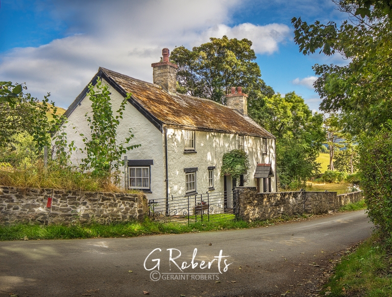
Entry Name: Caledfryn

Listing Date: 22 December 1989

Last Amended: 22 December 1989

Grade: II

Source: Cadw

Source ID: 1239

Building Class: Domestic

Also known as: Caledfryn,Dinbren

ID on this website: 300001239

Location: To N of Dinbren Hall near the boundry of the Community Council area. Set in the slope.

County: Denbighshire

Community: Llangollen

Community: Llangollen

Locality: Dinbren

Traditional County: Denbighshire

Tagged with: Architectural structure

Find accommodation in
Llangollen

History

Shown on 1844 Tithe Map; probably built as Dinbren estate cottages; although may have C18 origins.

Exterior

2-storey, rubble with asbestos tile roof and rubble chimney stack to right end. Caledfryn has broad whitewashed 2-window front and attached cottage has 1-window pebbledash front. Various small pane casements throughout; Caledfryn has an additional ground floor window to left of the off centre entrance. Boarding on the roof ridge above this section indicates the removal of a chimney stack sited backing onto the entry. Gabled porches, with finial to right; boarded doors.
Similar windows to whitewashed left gable end; gable end to right with lean-to and cross range at rear.

In fairly poor condition at time of inspection (March 1989).

Reasons for Listing

Included for its association with the Dinbren estate.

External Links

External links are from the relevant listing authority and, where applicable, Wikidata. Wikidata IDs may be related buildings as well as this specific building. If you want to add or update a link, you will need to do so by editing the Wikidata entry.

Recommended Books

Other nearby listed buildings

  • II Cottage attached to Caledfryn
    To N of Dinbren Hall near the boundry of the Community Council area. Set in the slope.
  • II Dinbren Hall
    Prominently sited on the edge of a steep slope to W of Castell Dinas Bran. The house faces S and is reached by a drive from the by-road which runs E from Pentrefellin and N from the town centre.
  • II Dinbren-isaf
    The scattered community of Dinbren lies to the N of Llangollen, behind Dinas-bran. The farm lies along a farm road off the road to Eglwyseg. The house stands on a bank facing S, with the farm buildi
  • II Pentrefelin Bridge, Llangollen Canal Bridge No 48
    The bridge spans the Llangollen Canal N of Llangollen and immediately E of Pentrefelin, at the foot of the Horseshoe Pass, carrying the road to the Pentrefelin works which are immediately to W.
  • II Fron Deg
    Approximately 1km N of the town centre. Above the road close to the junction with Tower Road and the modern road bridge over the Llangollen Canal.
  • II Pentrefelin (Afon Eglwyseg) Aquaduct
    Located in Pentrefelin, near the junction of the A542 with the B5013, NNW of Llangollen.
  • II Sycamore
    Approximately 1km NW of the town centre. Below the road with rear elevation overlooking the railway. On steeply sloping ground close to modern road bridge over the Llangollen Canal.
  • II Pentrefelin Tramway Viaduct
    The viaduct crosses the valley of the River Eglwyseg immediately NE of the junction of the A542 and the B5103 at Pentrefelin.

BritishListedBuildings.co.uk is an independent online resource and is not associated with any government department. All government data published here is used under licence. Please do not contact BritishListedBuildings.co.uk for any queries related to any individual listed building, planning permission related to listed buildings or the listing process itself.

British Listed Buildings is a Good Stuff website.