History in Structure

Cilmedw Cottages

A Grade II Listed Building in Llangollen, Denbighshire

We don't have any photos of this building yet. Why don't you be the first to send us one?

Upload Photo »

Approximate Location Map
Large Map »

Coordinates

Latitude: 52.9747 / 52°58'28"N

Longitude: -3.1801 / 3°10'48"W

OS Eastings: 320852

OS Northings: 342579

OS Grid: SJ208425

Mapcode National: GBR 6Y.JN08

Mapcode Global: WH784.3HYC

Plus Code: 9C4RXRF9+VX

Entry Name: Cilmedw Cottages

Listing Date: 22 December 1989

Last Amended: 22 December 1989

Grade: II

Source: Cadw

Source ID: 1248

Building Class: Domestic

ID on this website: 300001248

Location: Approximately 1km NW of the town centre midway between The Duke and The Geraint. At a splayed angle to the road at the point where the old lane following the W bank of the River Dee meets the later H

County: Denbighshire

Community: Llangollen

Community: Llangollen

Built-Up Area: Llangollen

Traditional County: Denbighshire

Tagged with: Building

Find accommodation in
Llansantffraid Glyn Ceiriog

Exterior

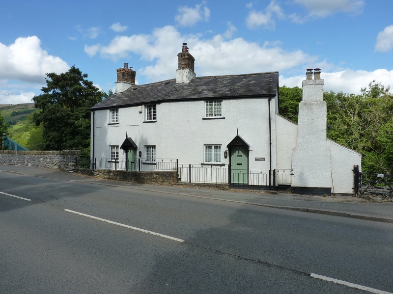
No 2 has an early C19 2-storey, 1-window pebbledash front. Slate roof and chimney stack heightened in stock brick with cornice. Multipane casement windows and boarded door under a gabled hood with finial and pendant. No 1 is steeped down a long way to right and is dominated by a massive lateral chimney breast to the front wall - also pebbledashed; stepped at the top. The unusual size of this suggests that it may have been a bakehouse.

External Links

External links are from the relevant listing authority and, where applicable, Wikidata. Wikidata IDs may be related buildings as well as this specific building. If you want to add or update a link, you will need to do so by editing the Wikidata entry.

Recommended Books

Other nearby listed buildings

  • II Colmedw Cottages
    Approximately 1km NW of the town centre midway between The Duke and The Geraint. At a splayed angle to the road at the point where the old lane following the W bank of the River Dee meets the later H
  • II Penddol
    Below the E bank of the Llangollen Canal and to N of the Eisteddfod ground. Reached off Abbey Road and over Canal bridge No 46.
  • II Canal Bridge (no.46 at Penddol)
    Immediately to S Penddol and N of the Eisteddfod ground. Spanning the Llangollen Canal and reached off Abbey Road.
  • II Arnon Cottage
    At right angles to the bend in the road; on the edge of the town. Railway below to the left.
  • II The Tower
    Above the road on a bend in the hill. A prominent building when looking E from The Geraint. Said to have been a watchtower for Castle Dinas Bran; also sometime school.
  • II Sycamore
    Approximately 1km NW of the town centre. Below the road with rear elevation overlooking the railway. On steeply sloping ground close to modern road bridge over the Llangollen Canal.
  • II Fair View (including outbuilding Range to right)
    At right angles to the north western edge of the town; faces SE.
  • II Fron Deg
    Approximately 1km N of the town centre. Above the road close to the junction with Tower Road and the modern road bridge over the Llangollen Canal.

BritishListedBuildings.co.uk is an independent online resource and is not associated with any government department. All government data published here is used under licence. Please do not contact BritishListedBuildings.co.uk for any queries related to any individual listed building, planning permission related to listed buildings or the listing process itself.

British Listed Buildings is a Good Stuff website.