Approximate Location Map
Large Map »
Latitude: 52.8642 / 52°51'51"N
Longitude: -3.2176 / 3°13'3"W
OS Eastings: 318123
OS Northings: 330330
OS Grid: SJ181303
Mapcode National: GBR 6W.RQWK
Mapcode Global: WH78P.K80K
Plus Code: 9C4RVQ7J+MW
Entry Name: Telephone Call-box adjoining churchyard wall at St Cadwaladr's church, Llangadwaldr
Listing Date: 11 May 1990
Last Amended: 25 September 2003
Grade: II
Source: Cadw
Source ID: 1331
Building Class: Communications
ID on this website: 300001331
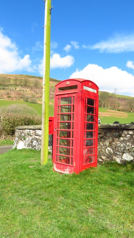
Location: In an attractive upland location beside by road and backing on to rubble churchyard wall (with VR wall-box adjoining to left and telephone pole beside).
County: Powys
Community: Llansilin
Community: Llansilin
Locality: Llangadwaladr
Traditional County: Denbighshire
Tagged with: Red telephone box K6 telephone box
To the standard design of Giles Gilbert Scott, introduced by GPO in 1936; this example dating from the reign of King George VI.
K6-type red telephone kiosk of cast-iron construction. Foundry plate indistinct.
Domed roof with four lunettes containing embossed crowns over red lettered opals and ventilation slits. Raised surrounds to sides and door with marginal bars to horizontal glazing. Blank rear, moulded plinth. Foundry plate indistinct.
Included for exceptionally attractive rural location adjoining churchyard of listed building.
External links are from the relevant listing authority and, where applicable, Wikidata. Wikidata IDs may be related buildings as well as this specific building. If you want to add or update a link, you will need to do so by editing the Wikidata entry.


Other nearby listed buildings
