History in Structure

Telephone Call-box adjacent to W gable end of Hand Inn

A Grade II Listed Building in Ceiriog Ucha, Wrexham

More Photos »
Approximate Location Map
Large Map »

Coordinates

Latitude: 52.8862 / 52°53'10"N

Longitude: -3.2544 / 3°15'15"W

OS Eastings: 315692

OS Northings: 332815

OS Grid: SJ156328

Mapcode National: GBR 6V.Q7YR

Mapcode Global: WH78G.ZQG8

Plus Code: 9C4RVPPW+F6

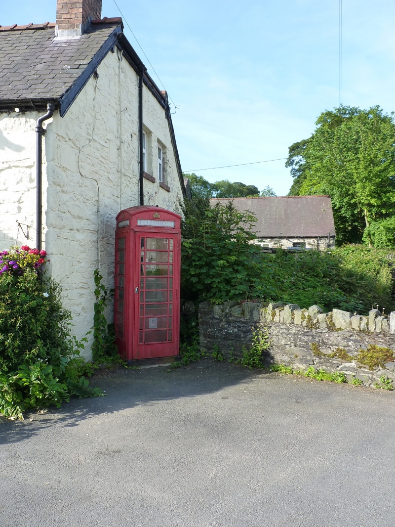
Entry Name: Telephone Call-box adjacent to W gable end of Hand Inn

Listing Date: 11 May 1990

Last Amended: 23 May 2003

Grade: II

Source: Cadw

Source ID: 1332

Building Class: Communications

ID on this website: 300001332

Location: Located in the centre of the village in the SE angle of the crossroads. Set diagonally to the W gable end of the Hand Inn.

County: Wrexham

Community: Ceiriog Ucha

Community: Ceiriog Ucha

Locality: Llanarmon Dyffryn Ceiriog

Traditional County: Denbighshire

Tagged with: Red telephone box K6 telephone box

Find accommodation in
Llanarmon Dyffryn-Ceiriog

History

Built to the standard design of Giles Gilbert Scott, architect of London. Design introduced by GPO in 1936; this example dates from the reign of King George VI.

Exterior

K6-type square, red kiosk of cast-iron construction. Domed roof with 4 lunettes containing embossed crowns over red lettered opals and ventilation slits. Raised surrounds to sides and door with marginal bars to horizontal glazing. Foundry plate not visible. Blank rear, moulded plinth.

Reasons for Listing

Listed for its contribution to the character of this fine conservation area.

External Links

External links are from the relevant listing authority and, where applicable, Wikidata. Wikidata IDs may be related buildings as well as this specific building. If you want to add or update a link, you will need to do so by editing the Wikidata entry.

Recommended Books

Other nearby listed buildings

  • II Old Mill Welsh Shop
    To the SW of the main crossroads in the centre of the village. The building is located between 2 short rows of houses and is approached from the N or S.
  • II The West Arms Hotel
    In the NW angle of the main crossroads in the centre of the village. The hotel fronts the road.
  • II Church of St Garmon
    In a picturesque location in the Ceiriog Valley, on the E edge of the village.
  • II Milestone to NE of Llanarmon Dyffryn Ceiriog
    Located on the N side of the road on a grass bank, close to Pont Fawr which carries the B4500 into the village.
  • II Pen y bryn
    The farm is on a narrow lane which runs N from Llanarmon Dyffryn Ceiriog towards Nantyr. It is located within a sharp bend on the E side of the lane, approx 0.5km from the village centre, and faces S
  • II Secondary Dwelling at Hafod Adams
    Located immediately to the W of Harod Adams Farmhouse. The W elevation overlooks the Nant Caledwynt, whilst the E side faces the farmhouse.
  • II Hafod Adams
    Located on the W side of a lane which runs N from the B4500, between Tregeiriog and Llanarmon Dyffryn Ceiriog. The entrance faces W, away from the road.
  • II Ty'n y rhos
    The farm is reached off the E side of a track which runs N from Llanarmon Dyffryn Ceiriog towards Nantyr. It is approx 1.5km from the village centre. The cottage faces S and is built along the slope

BritishListedBuildings.co.uk is an independent online resource and is not associated with any government department. All government data published here is used under licence. Please do not contact BritishListedBuildings.co.uk for any queries related to any individual listed building, planning permission related to listed buildings or the listing process itself.

British Listed Buildings is a Good Stuff website.