Latitude: 51.6449 / 51°38'41"N
Longitude: -3.1192 / 3°7'8"W
OS Eastings: 322657
OS Northings: 194604
OS Grid: ST226946
Mapcode National: GBR J0.7Q39
Mapcode Global: VH6DG.WXDD
Plus Code: 9C3RJVVJ+X8
Entry Name: Rhyswg Fawr Farmhouse and walled forecourt
Listing Date: 27 January 1982
Last Amended: 17 December 1998
Grade: II
Source: Cadw
Source ID: 1900
Building Class: Domestic
ID on this website: 300001900
Location: High on the mountain reached by a long lane and track rising from the SE end of Abercarn village, on the S side of the Gwyddon valley.
County: Caerphilly
Community: Abercarn
Community: Abercarn
Locality: Rhyswg
Traditional County: Monmouthshire
Tagged with: Farmhouse
Probably early C17, with later alterations. The left unit is the original house; the right unit was formerly a byre and later incorporated into the dwelling, with an inserted floor probably in place of an earlier hayloft. This land before the Reformation was part of Llantarnam Abbey estate and the former house name, Rhyswg Grange, may refer to a medieval outlier of the monastic settlement here. In C16 estate leased by Queen Elizabeth to Earl of Pembroke and in 1570 the second earl inherited his estate, including the land of Llantarnam Abbey, and carried out a survey. Later the estate was owned by owner of Abercarn Ironworks and then by the Crawshay Ironmasters. Subsequently Abercarn Estate was merged with Llanover Estate on the marriage of Sir Benjamin Hall and Augusta Waddington, the later Lord and Lady Llanover.
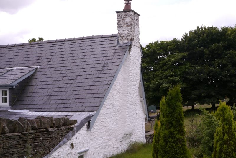
Long farmhouse incorporating former byre. Of limewashed rubble with steep felted roof, formerly stone tiled with end stack right and corbelled chimney to left; centre ridge stack, described as massive in original list description, replaced. 2 unit plan, the older to left, with rear outshut, built into the hillside. Single storey and attic. To left 3 casement windows to ground floor, that to right with timber lintel, the centre probably a former doorway with a stone hood, shallow stone hood and sill to left window; gabled dormer above; small window with stone hood beside the corbelled fireplace to gable end. Wide central flat-roofed porch across the units has large quoins and voussoirs to doorway with boarded door, but earlier small side window with hood. Renewed window to ground floor right, with two 6-pane casements rising through the eaves above, at a different level from left unit. Catslide roof over single storey outshut to rear; casement windows. The shallow walled forecourt has a trigonometrical point on one of the gate piers with mounting block attached.
Interior retains cross passage running outside fireplace gable of original dwelling to left with wide segmental arched doorway to hall. The hall retains heavy chamfered and stopped beams and close-set chamfered and stopped joists all numbered with carpenter's marks. Spiral stone stairs rise to left of open fireplace with bread oven; opposite is a post and panel sceen with two doorways with lost heads to former buttery and pantry. Farmhouse roof consists of an upper-cruck truss with block apex and notched collars; the former byre has an A-frame roof with raised collar. Dairy and kitchen to later outshut.
Listed as a traditional regional upland farmhouse retaining most of its historic fabric. Group value with nearby barn.
External links are from the relevant listing authority and, where applicable, Wikidata. Wikidata IDs may be related buildings as well as this specific building. If you want to add or update a link, you will need to do so by editing the Wikidata entry.


Other nearby listed buildings