History in Structure

Telephone Call-box

A Grade II Listed Building in Raglan, Monmouthshire

More Photos »
Approximate Location Map
Large Map »

Coordinates

Latitude: 51.7306 / 51°43'50"N

Longitude: -2.8491 / 2°50'56"W

OS Eastings: 341452

OS Northings: 203880

OS Grid: SO414038

Mapcode National: GBR JD.2022

Mapcode Global: VH79P.KRMQ

Plus Code: 9C3VP5J2+68

Entry Name: Telephone Call-box

Listing Date: 24 August 1990

Last Amended: 31 January 2001

Grade: II

Source: Cadw

Source ID: 2839

Building Class: Communications

ID on this website: 300002839

Location: Situated in village, on S side of road beside gable end of Orchard House.

County: Monmouthshire

Town: Usk

Community: Raglan (Rhaglan)

Community: Raglan

Locality: Llandenny

Traditional County: Monmouthshire

Tagged with: Red telephone box

Find accommodation in
Llandenny

History

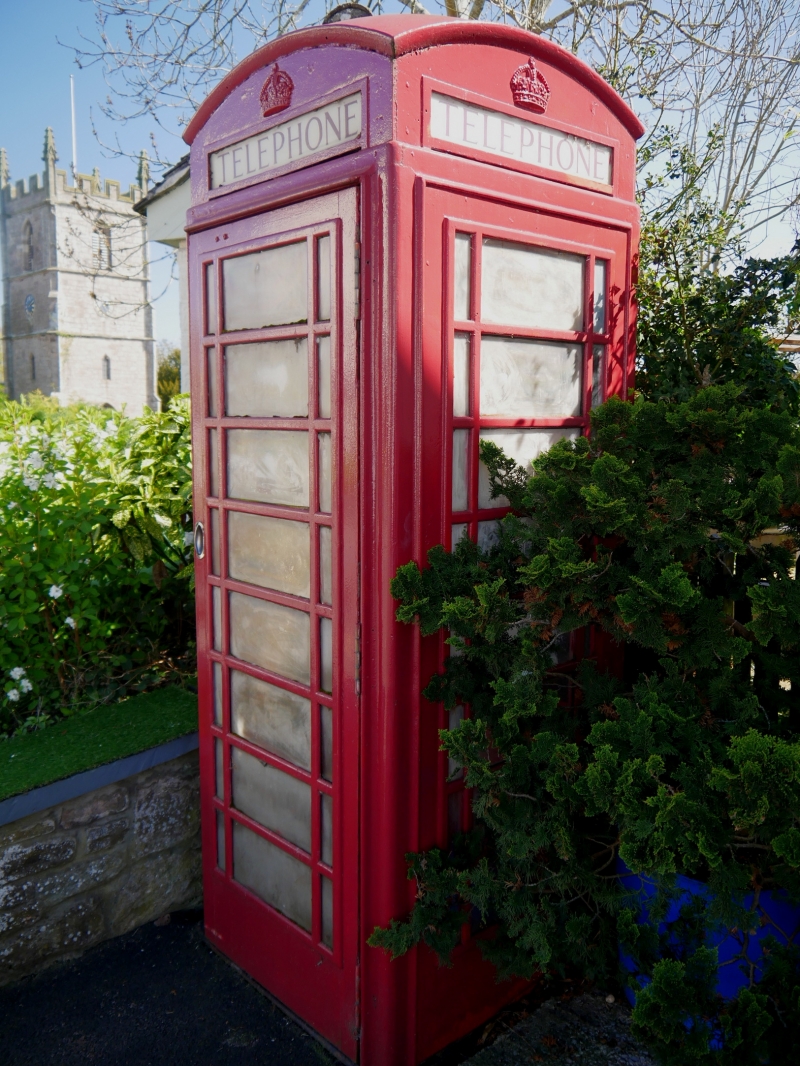
Telephone call-box of K6 type designed by Sir Giles Gilbert Scott for the GPO and introduced in 1936, this example dating from the reign of George VI. Telephone number 01291 690498.

Exterior

Telephone call-box, square, red-painted cast-iron kiosk with wooden door. Domed roof with four lunettes containing embossed crowns over red lettered opals (one missing) and ventilation slits. Raised surrounds to sides and door with marginal bars to horizontal glazing. Blank rear, moulded plinth. Rear foundry plate not visible.

Reasons for Listing

Included as well sited example within the Conservation Area.

External Links

External links are from the relevant listing authority and, where applicable, Wikidata. Wikidata IDs may be related buildings as well as this specific building. If you want to add or update a link, you will need to do so by editing the Wikidata entry.

Recommended Books

Other nearby listed buildings

  • II Lych-gate to the church of St John
    Situated at the entrance to Llandenny churchyard in Llandenny village.
  • II Barn at Village Farm
    Situated in Llandenny village opposite entry to churchyard, at upper W side of farmyard at the former Pentre Farm, now Village Farm.
  • II Cross in St John's churchyard
    The Cross is situated in Llandenny churchyard some 3m SE of the church porch.
  • I Church of St John
    Situated in the centre of the village of Llandenny. The church is in an elevated position within an enclosed churchyard.
  • II Village Farm
    Situated on S side of road through Llandenny, attached to Church Farm of which this was a former outbuilding.
  • II Church Farm
    Situated on S side of the road in Llandenny village, the last property on the E towards Llandenny Bottoms.
  • II Barn and cowshed at The Rock Farm
    Situated across S end and E side of farmyard at The Rock.
  • II The Rock Farmhouse
    Situated down drive some 500 m W of Llandenny church, S of minor road to Llandenny Walks. Front court enclosed by whitewashed rubble walls.

BritishListedBuildings.co.uk is an independent online resource and is not associated with any government department. All government data published here is used under licence. Please do not contact BritishListedBuildings.co.uk for any queries related to any individual listed building, planning permission related to listed buildings or the listing process itself.

British Listed Buildings is a Good Stuff website.