History in Structure

Pont Bethania

A Grade II Listed Building in Beddgelert, Gwynedd

More Photos »
Approximate Location Map
Large Map »

Coordinates

Latitude: 53.0354 / 53°2'7"N

Longitude: -4.0481 / 4°2'53"W

OS Eastings: 262766

OS Northings: 350644

OS Grid: SH627506

Mapcode National: GBR 5T.DTBG

Mapcode Global: WH551.SYJV

Plus Code: 9C5Q2XP2+5Q

Entry Name: Pont Bethania

Listing Date: 29 May 1968

Last Amended: 25 November 1998

Grade: II

Source: Cadw

Source ID: 3746

Building Class: Transport

ID on this website: 300003746

Location: Spanning the Afon Glaslyn approximately 2.5km NE of Beddgelert village and carrying the old turnpike road; immediately SE of the modern road bridge.

County: Gwynedd

Town: Caernarfon

Community: Beddgelert

Community: Beddgelert

Locality: Bethania

Traditional County: Caernarfonshire

Tagged with: Bridge Road bridge

Find accommodation in
Beddgelert

History

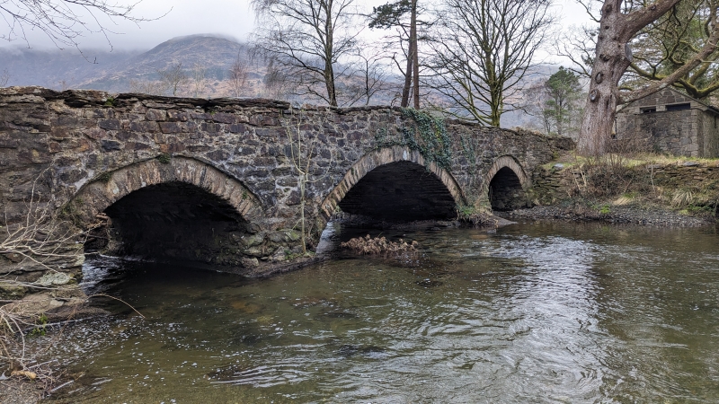
Built c1805 for the new line of the Porthdinllaen-Capel Curig turnpike road.

Exterior

Large triple-span road bridge, approximately 20m long. Of rubble construction with wide segmental central arch and smaller segmental flanking arches; rough-dressed voussoirs recessed below archrings of narrow stones. On the upstream side are 2 low triangular cutwaters. The carriageway is humped to the centre and has slab-coped parapets, splayed at the approaches and terminating, at the southern end, in flat, shallow buttresses. At both ends the parapets adjoin low modern rubble walls.

Reasons for Listing

Listed for its special interest as a good early C19 3-span road bridge.

External Links

External links are from the relevant listing authority and, where applicable, Wikidata. Wikidata IDs may be related buildings as well as this specific building. If you want to add or update a link, you will need to do so by editing the Wikidata entry.

Recommended Books

Other nearby listed buildings

  • II Bethania Chapel
    Located prominently by the side of the main road in Bethania and raised up on a revetted, sloped terrace with simple fleur-de-lis railings surmounting the wall in front of the chapel; adjoining the fo
  • II Field Cowhouse NE of Llyndy Isaf
    Located on the brow of a hill to the NE of Llyndy Isaf farm, approximately 750m S of Bethania; accessed via a track running SW from the road leading from Bethania to the Nanmor valley.
  • II Stable and Cartshed at Hafod y Llan
    At the foot of Cwm y Llan in Nant Gwynant (between Llyn Dinas and Llyn Gwynant). The haybarn is set on the SW side of the yard, beyond the cowhouses.
  • II Haybarn at Hafod y Llan
    Situated at the foot of Cwm y Llan (between Llyn Dinas and Llyn Gwynant). The haybarn is set immediately outside the main farmyard, behind the cowhouses.
  • II Cowhouse at Hafod y Llan
    Situated at the foot of Cwm y Llan between Llyn Dinas and Llyn Gwynant. The cowhouse encloses the yard to the NW.
  • II Hafod-y-Llan
    Located on the NW side of the Afon Glaslyn set back a quarter of a kilometer from the road between Bethania and the Llyn Gwynant; at the end of a lane running parallel with the main road and immediate
  • II Foot Bridge 100m E of Ysgoldy
    Spanning the Afon Glaslyn approximately 100m N of the main road and 100m E of Ysgoldy.

BritishListedBuildings.co.uk is an independent online resource and is not associated with any government department. All government data published here is used under licence. Please do not contact BritishListedBuildings.co.uk for any queries related to any individual listed building, planning permission related to listed buildings or the listing process itself.

British Listed Buildings is a Good Stuff website.