History in Structure

Telephone Call-box

A Grade II Listed Building in Llanllechid, Gwynedd

More Photos »
Approximate Location Map
Large Map »

Coordinates

Latitude: 53.1968 / 53°11'48"N

Longitude: -4.0628 / 4°3'45"W

OS Eastings: 262298

OS Northings: 368620

OS Grid: SH622686

Mapcode National: GBR 5S.2PKQ

Mapcode Global: WH548.KXK4

Plus Code: 9C5Q5WWP+PV

Entry Name: Telephone Call-box

Listing Date: 18 November 1988

Last Amended: 9 March 2000

Grade: II

Source: Cadw

Source ID: 4149

Building Class: Communications

ID on this website: 300004149

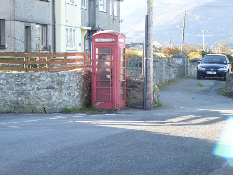
Location: In the centre of the village at the southern end of a Y-road-junction; set into a corner beside a rubblestone boundary wall.

County: Gwynedd

Community: Llanllechid

Community: Llanllechid

Traditional County: Caernarfonshire

Tagged with: K6 telephone box

Find accommodation in
Llanllechid

History

K6 telephone kiosk constructed to Giles Gilbert Scott''s standard design, introduced by the General Post Office in 1936; this example dates from the reign of George VI.

Exterior

Red-painted cast-iron. Domed roof with 4 lunettes containing embossed crowns over black-lettered opals and ventilation slits. Raised surrounds to sides and door with margin lights to horizontal glazing bars; moulded plinth.

Reasons for Listing

Included for its group value in this rural conservation area.

External Links

External links are from the relevant listing authority and, where applicable, Wikidata. Wikidata IDs may be related buildings as well as this specific building. If you want to add or update a link, you will need to do so by editing the Wikidata entry.

Recommended Books

Other nearby listed buildings

  • II Sundial at the Church of St Llechid
    Situated immediately to the south of the south-west corner of the nave of the Church of St Llechid.
  • II Church of St Llechid
    Located in village in long rectangular churchyard boarded by rubblestone wall with stone-on-edge coping; entrance to north-east has circular piers and spiked iron gates, from which a long yew avenue l
  • II Coed-uchaf
    Set on sharp bend on track running off the west side of the minor road between Bethesda and Tal-y-bont approximately 0.5km north-west of Rachub; slate fencing to south and west boundaries, rubblestone
  • II Outbuildings in farm-court at Coetmor Farm
    Situated about 1 km NNW of centre of Bethesda, just N of Coetmor Farmhouse, forming the E, N and W ranges of an enclosed farm-court, of which the barn on S side is listed separately.
  • II Barn at Coetmor Farm
    Situated about 1 km NNW of centre of Bethesda, just N of Coetmor Farmhouse, forming the S range of an enclosed farm-court.
  • II Coetmor Farmhouse
    Situated on NE side of Coetmor Road about 1 km NNW of centre of Bethesda.
  • II Outbuildings at Pandy Newydd
    Situated directly to the east of Pandy Newydd.
  • II Pandy Newydd
    Situated in isolated rural position in wooded grounds reached by a long track running off the east side of the A5 south of Halfway Bridge.

BritishListedBuildings.co.uk is an independent online resource and is not associated with any government department. All government data published here is used under licence. Please do not contact BritishListedBuildings.co.uk for any queries related to any individual listed building, planning permission related to listed buildings or the listing process itself.

British Listed Buildings is a Good Stuff website.