History in Structure

Sundial at the Church of St Llechid

A Grade II Listed Building in Llanllechid, Gwynedd

More Photos »
Approximate Location Map
Large Map »

Coordinates

Latitude: 53.1972 / 53°11'49"N

Longitude: -4.0644 / 4°3'52"W

OS Eastings: 262187

OS Northings: 368667

OS Grid: SH621686

Mapcode National: GBR 5S.2P4D

Mapcode Global: WH548.JWRV

Plus Code: 9C5Q5WWP+V6

Entry Name: Sundial at the Church of St Llechid

Listing Date: 9 March 2000

Last Amended: 9 March 2000

Grade: II

Source: Cadw

Source ID: 22941

Building Class: Religious, Ritual and Funerary

ID on this website: 300022941

Location: Situated immediately to the south of the south-west corner of the nave of the Church of St Llechid.

County: Gwynedd

Community: Llanllechid

Community: Llanllechid

Traditional County: Caernarfonshire

Tagged with: Sundial
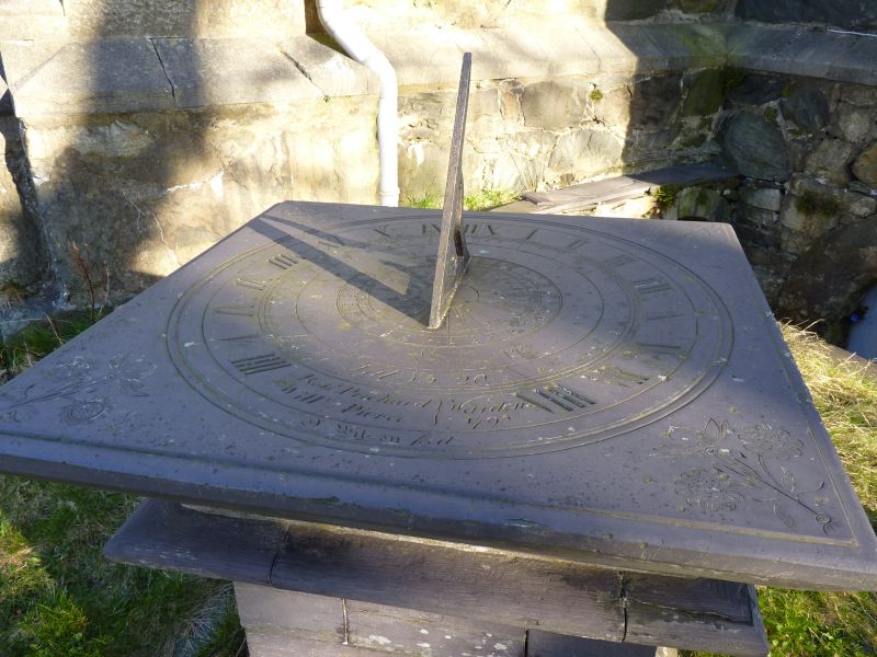
Find accommodation in
Llanllechid

History

Sundial dated 1795.

Exterior

Slate top slab with bevelled edge on square pedestal with moulded and chamfered plinth and moulded capping, the whole constructed of very finely cut and jointed slate slabs. Top slab with painted replacement gnomon has flowers inscribed to corners and inscription "Lat. 53 degrees 20/ Robt. Prichard, Willm. Pierce} Wardens 1795/ N. Wilson fecit".

Reasons for Listing

Included as an unusually well-detailed late C18 sundial; strong group value with the Church of St Llechid.

External Links

External links are from the relevant listing authority and, where applicable, Wikidata. Wikidata IDs may be related buildings as well as this specific building. If you want to add or update a link, you will need to do so by editing the Wikidata entry.

Recommended Books

Other nearby listed buildings

  • II Church of St Llechid
    Located in village in long rectangular churchyard boarded by rubblestone wall with stone-on-edge coping; entrance to north-east has circular piers and spiked iron gates, from which a long yew avenue l
  • II Telephone Call-box
    In the centre of the village at the southern end of a Y-road-junction; set into a corner beside a rubblestone boundary wall.
  • II Coed-uchaf
    Set on sharp bend on track running off the west side of the minor road between Bethesda and Tal-y-bont approximately 0.5km north-west of Rachub; slate fencing to south and west boundaries, rubblestone
  • II Outbuildings at Pandy Newydd
    Situated directly to the east of Pandy Newydd.
  • II Pandy Newydd
    Situated in isolated rural position in wooded grounds reached by a long track running off the east side of the A5 south of Halfway Bridge.
  • II Outbuildings in farm-court at Coetmor Farm
    Situated about 1 km NNW of centre of Bethesda, just N of Coetmor Farmhouse, forming the E, N and W ranges of an enclosed farm-court, of which the barn on S side is listed separately.
  • II Barn at Coetmor Farm
    Situated about 1 km NNW of centre of Bethesda, just N of Coetmor Farmhouse, forming the S range of an enclosed farm-court.
  • II Coetmor Farmhouse
    Situated on NE side of Coetmor Road about 1 km NNW of centre of Bethesda.

BritishListedBuildings.co.uk is an independent online resource and is not associated with any government department. All government data published here is used under licence. Please do not contact BritishListedBuildings.co.uk for any queries related to any individual listed building, planning permission related to listed buildings or the listing process itself.

British Listed Buildings is a Good Stuff website.