Approximate Location Map
Large Map »
Latitude: 52.9458 / 52°56'44"N
Longitude: -4.3422 / 4°20'31"W
OS Eastings: 242723
OS Northings: 341276
OS Grid: SH427412
Mapcode National: GBR 5F.LFP7
Mapcode Global: WH44C.87K1
Plus Code: 9C4QWMW5+84
Entry Name: Ffynnon Cybi and associated works
Listing Date: 19 October 1971
Last Amended: 31 March 1999
Grade: I
Source: Cadw
Source ID: 4343
Building Class: Religious, Ritual and Funerary
Also known as: Saint Cybi's Well
St. Cybi's Well
Ffynnon Gybi
ID on this website: 300004343
Location: The well lies in the narrow valley below the slopes of Garn Bentyrch, and is reached by a footpath from the NE corner of the churchyard, crossing two fields, the second by a causeway.
County: Gwynedd
Town: Pwllheli
Community: Llanystumdwy
Community: Llanystumdwy
Locality: Llangybi
Traditional County: Caernarfonshire
Tagged with: Holy well
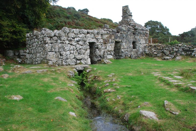
The well of St Cybi is of great antiquity, and has probably been venerated from earliest times particularly for the curative properties of the waters. St Cybi is a saint of Cornish origin who had settled in Ireland when, following a dispute, he moved with his followers to NW Wales where he is associated with holy wells. The cult grew in importance through the medieval period, the water here being considered beneficial particularly for the treatment of eye complaints, skin diseases and rheumatism. The reputation of the well waters survived the reformation and continued in popularity at least until the late C18 when walking aids were still abandoned at the well. The cottage attached to the well house was probably erected c1750 by the landowner William Price of Rhiwlas to rest pilgrims after taking the waters as part of the prescribed treatment; this included taking the water with seawater followed by periods of rest over 7-10 days. The waters were also bottled and sold as medicine. Latterly the well was used on the eve of the gwylmabsant and for the divination of lovers' hopes indicated by observing a feather placed on the water. The main well house was clearly already in existence and may be C17 or earlier.
The site consists of a well house, a secondary well house added at the rear, and a cottage for pilgrims attached on the E side, the site being approached by a wide paved causeway, with a second causeway leading to the ty-bach set over the stream to the west. The well house is roughly 5m square internally, the external corners splayed, and rising approximately 3.3m to the springing of a corbelled dome. A single door opening on the S side. The cottage consisted of a single heated room with attic floor over now removed. It has a door opening against the external wall of the well house, and a single window. The roof was pitched, with a stack on the thick E gable end. The wall offsets at the rear. The secondary well house is attached to the rear, built into the slope and over the actual water source. Its access is placed on the W side against the rear wall of the main structure.
The main well chamber, for which there is evidence of a corbelled vault, contains a sunken tank approximately 2.2m x 1.5m and 1m deep, with a surrounding walkway, narrow at the rear, and having steps down on the E and W. Various niches in the walls, probably for the bathers' clothing. The waters pass from the smaller wellhouse below the N wall directly into the tank, and exit under the front wall to an open culvert leading away to the SW. A later door, now blocked, lead directly into the cottage. The cottage has a small fireplace in the gable wall, and a recess probably for the stair on the rear wall.
A cobbled causeway 1.1m wide leads parallel to the culvert some 17m to the single square latrine, now ruined.
Included at Grade I as one of the most important and best preserved of the holy wells of Wales, and one with which numerous legends are associated.
External links are from the relevant listing authority and, where applicable, Wikidata. Wikidata IDs may be related buildings as well as this specific building. If you want to add or update a link, you will need to do so by editing the Wikidata entry.


Other nearby listed buildings
