History in Structure

The Feathers Inn

A Grade II Listed Building in Llanystumdwy, Gwynedd

More Photos »
Approximate Location Map
Large Map »

Coordinates

Latitude: 52.9212 / 52°55'16"N

Longitude: -4.2692 / 4°16'9"W

OS Eastings: 247538

OS Northings: 338390

OS Grid: SH475383

Mapcode National: GBR 5J.N1D2

Mapcode Global: WH44D.DT8W

Plus Code: 9C4QWPCJ+F8

Entry Name: The Feathers Inn

Listing Date: 19 October 1971

Last Amended: 31 March 1999

Grade: II

Source: Cadw

Source ID: 4356

Building Class: Commercial

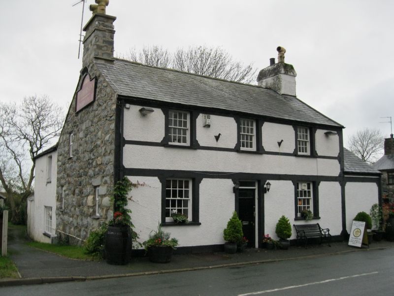
Also known as: Tafarn Y Plu (Feathers Inn)
Tafarn Y Plu (Feathers Inn), Criccieth

ID on this website: 300004356

Location: The inn lies at the E end of the village, on the S side of the village street.

County: Gwynedd

Town: Criccieth

Community: Llanystumdwy

Community: Llanystumdwy

Traditional County: Caernarfonshire

Tagged with: Pub Inn

Find accommodation in
Criccieth

History

Probably built mid C19 with later alterations.

Exterior

Built of rubble stonework and pebbledashed between decorative smooth rendered bands and architraves to doors and windows bracketed to a sill string, lintels, plinth band, and quoins. Two storey, 3 window bays, with an attached wing on the west. Slate roof with gable stacks. Central bead-panelled door with a glazed panel, and overlight. Recessed 16-pane sash windows. The wing to the right is single storey, altered in the C20. A long and conspicuous range of white painted outbuildings run S from the E end.

Interior

The front door opens to a stair hall, with living rooms (bars) to right and left. Open joisted ceiling. Gable fireplace of painted stone.

Reasons for Listing

Included as a good example of an inn retaining its C19 vernacular character, including decorative treatment denoting its function, and forming a significant terminal building of the village, of group value with other listed buildings in the conservation area.

External Links

External links are from the relevant listing authority and, where applicable, Wikidata. Wikidata IDs may be related buildings as well as this specific building. If you want to add or update a link, you will need to do so by editing the Wikidata entry.

Recommended Books

Other nearby listed buildings

  • II Ty Canton
    The house stands at the end of a row of houses on the N side of the main street of the village.
  • II Tabernacl
    The Tabernacl, also called Capel Bach, lies back from the S side of the street past a row of two cottages set end-on to the road.
  • II* Highgate
    The house is in a row on the NE side of the main street, E of the bridge.
  • II Tai Newyddion
    A row of four cottages alongside the village street, attached to Highgate on the right, and to the village shop on the left.
  • II Tai Newyddion
    A row of four cottages alongside the village street, attached to Highgate on the right, and to the village shop on the left.
  • II Tai Newyddion
    A row of four cottages alongside the village street, attached to Highgate on the right, and to the village shop on the left.
  • II Tai Newyddion
    A row of four cottages alongside the village street, attached to Highgate on the right, and to the village shop on the left.
  • II Front Walls and Gates to Moriah Methodist Chapel
    The front walls to the grassed forecourt of Capel Moriah are on the S side of the main road through the village.

BritishListedBuildings.co.uk is an independent online resource and is not associated with any government department. All government data published here is used under licence. Please do not contact BritishListedBuildings.co.uk for any queries related to any individual listed building, planning permission related to listed buildings or the listing process itself.

British Listed Buildings is a Good Stuff website.