Approximate Location Map
Large Map »
Latitude: 52.923 / 52°55'22"N
Longitude: -4.1302 / 4°7'48"W
OS Eastings: 256886
OS Northings: 338300
OS Grid: SH568383
Mapcode National: GBR 5P.MZ1Z
Mapcode Global: WH55L.JSFJ
Plus Code: 9C4QWVF9+5W
Entry Name: Madoc Yacht Club
Listing Date: 1 April 1974
Last Amended: 26 September 2005
Grade: II
Source: Cadw
Source ID: 4422
Building Class: Recreational
ID on this website: 300004422
Location: To the S of Cornhill and overlooking the harbour at Pencei.
County: Gwynedd
Town: Porthmadog
Community: Porthmadog
Community: Porthmadog
Built-Up Area: Porthmadog
Traditional County: Caernarfonshire
Tagged with: Architectural structure
Porthmadog Harbour was developed from the 3rd decade of the C19, at first by landowner and improver William Madocks (1773-1828). Madocks had reclaimed a large tract of land known as Traeth Mawr, that formed the estuary of the Afon Glaslyn, by building a Great Embankment (now known as The Cob) 1808-11. One of the fortuitous consequences of diverting the river was that it swept away sandbanks to leave a deep natural harbour ideal for serving the region's growing slate industry. The Act of Parliament for Porthmadog Harbour was passed in 1821. By 1824 the new port was already ready to receive vessels of up to 70 tons (71.12 tonnes) laden. The engineer was John Williams, and the contractor Griffith Griffith. Cornhill Wharf, on which Madoc Yacht Club is situated, was the original wharf and was built to comply with the provisions of the Act of Parliament. The slate companies who purchased wharfage at Porthmadog were responsible for building their own quays.
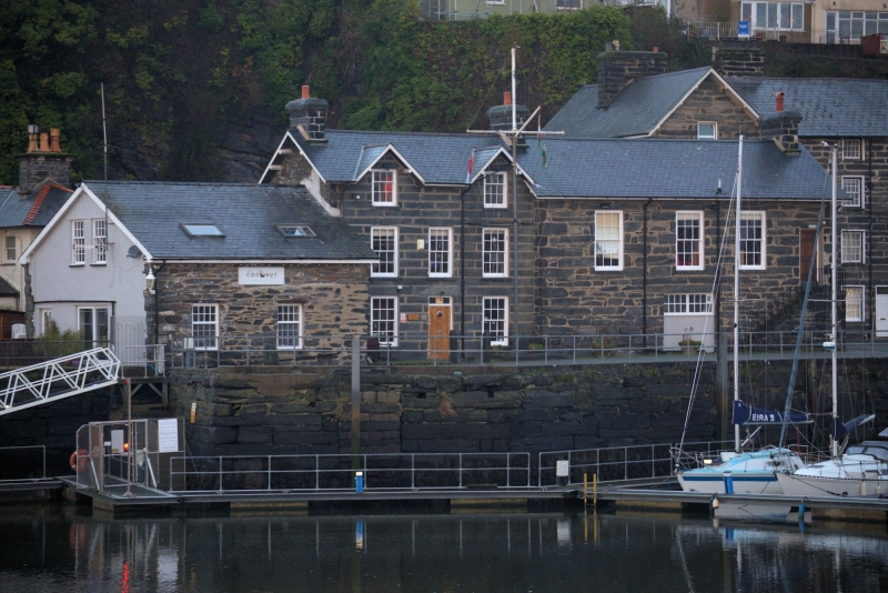
Madoc Yacht Club was built in the mid C19, probably partly as a house and the harbour office. The earliest section is probably the wing on the R-hand side, built in 1852 at the expense of David Williams of Deudraeth Castle, the upper storey of which housed a seamen's newsroom and library. By 1856 it subscribed to several newspapers and journals and had a library of 250 books. The whole building is shown on the 1871 Tremadog estate plan, 1885 harbour survey and 1888 Ordnance Survey.
A 3-storey house with 2-storey former newsroom set forward on its R side and a smaller 1-storey range set forward on the L side. The 3-window house is of coursed local slate-stone in regular squared blocks, with slate roof on overhanging eaves, and end stone stacks. The central replaced boarded door has an overlight. Windows are 12-pane hornless sashes in the lower and middle storey, narrower in the centre. The upper storey has 2 shorter 9-pane sash windows under gables. The 2-window L-hand range is of rubble slate-stone, including large undressed blocks and laid in rough courses, under a slate roof. It has replacement 20-pane sash windows. Its R side wall has a doorway blocked and converted to a window. The 3-window newsroom on the R is of large roughly dressed slate-stone blocks laid in regular courses, has a slate roof and end stack to the R. In the lower storey is a blocked double doorway with pebble-dashed infill and inserted window. The upper storey has 12-pane hornless sash windows. At the R end are external stone steps, with iron railings and renewed cement treads, to a fielded-panel door.
The R gable end has a blocked double doorway with pebble-dashed infill and 2 inserted windows, below a pointed newsroom window with thin glazing bars forming Y-tracery. The rear of the has another double doorway, blocked similar to the end and front doorways, and inserted boarded door to the R. The house has a single replacement door and window to the rear.
Not inspected.
Listed for its special social historical interest as a seamen's library, for its architectural interest as a prominent harbour-side building notable for its distinctive use of local stone and retaining definite C19 character and detail, and for its contribution to the historical integrity of Porthmadog harbour.
External links are from the relevant listing authority and, where applicable, Wikidata. Wikidata IDs may be related buildings as well as this specific building. If you want to add or update a link, you will need to do so by editing the Wikidata entry.


Other nearby listed buildings
