Approximate Location Map
Large Map »
Latitude: 52.8146 / 52°48'52"N
Longitude: -4.7394 / 4°44'21"W
OS Eastings: 215482
OS Northings: 327637
OS Grid: SH154276
Mapcode National: GBR GPN8.5TV
Mapcode Global: WH33M.5JD3
Plus Code: 9C4QR776+R6
Entry Name: Tanyfron
Listing Date: 26 June 1989
Last Amended: 26 June 1998
Grade: II
Source: Cadw
Source ID: 4619
Building Class: Domestic
ID on this website: 300004619
Location: Situated at Anelog on E side of road some 600m N of Ty'n Anelog farm.
County: Gwynedd
Town: Pwllheli
Community: Aberdaron
Community: Aberdaron
Locality: Anelog
Traditional County: Caernarfonshire
Tagged with: Farmhouse
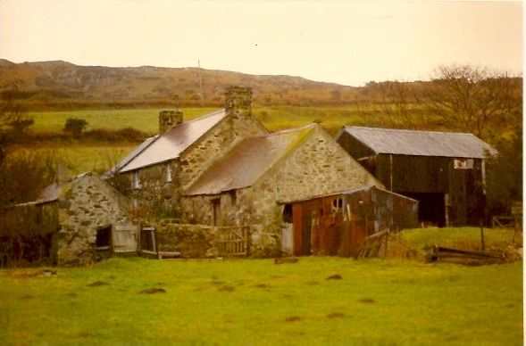
Small farmhouse, possibly later C18 in origin altered in C19 and gutted internally since 1989. The offset of the facade and big fireplace beam suggest a late C18 date, but it is probable that the house was raised as well as re-roofed in the C19. Owned by the National Trust. Not obviously marked on Tithe Map of 1844, though a house named as Ty'nyffynnon may be on the site.
Farmhouse, rubble stone with purple slate roof, coped gables and stone C19 end stacks. Two-storey, double front much offset to right, indicating that left chimney was probably formerly a larger kitchen stack. Two first floor 4-pane sashes under eaves, ground floor 4-pane sash left, smaller 2-pane sash right and half-glazed door. Slab lintels to ground floor. Rear is outshut to right with side entry and one window under eaves. 4-pane sash under eaves to left.
To left of main front, former stable with grouted slate roof and 8-pane fixed-light window under eaves to right. Door to rear left. To right of main front, former cow-house, with slate roof (old grouted slates rear). Stable door to centre with slab lintel, window to right under eaves. Rear door and window part-blocked.
Interior entirely gutted at time of inspection. Cambered timber lintel to fireplace left and beam over entry to rear outshut. 2 C19 roof trusses. Cow-house has C19 truss, half-loft over E end with tongue-and-groove boarding, possibly once in domestic use.
Included as a smaller vernacular farmhouse of C18 origins, with outbuildings in line.
External links are from the relevant listing authority and, where applicable, Wikidata. Wikidata IDs may be related buildings as well as this specific building. If you want to add or update a link, you will need to do so by editing the Wikidata entry.


Other nearby listed buildings
